Aloha-
Moon hoax conspiracy idiots are a spectacularly unoriginal bunch, which means the same easily discredited garbage gets regurgitated every so often and gullible idiots fall for it.
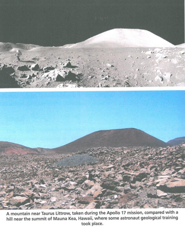
One such piece of garbage is the meme on the right.

Let’s deal with one thing straight away. Neither of the two images are Buzz Aldrin. That’s how accurate and concerned about facts these idiots are.
The bottom image is of John Young, who orbited the moon in Apollo 10 and walked on the surface in Apollo 16.
We know it’s John Young because we can trace the source to this page. It details his attendance at this conference.
On the left is the original photo. Just in case there’s any doubt about identity can just about make out his name on his badge. It’s even clearer in another image -


So where is the image taken? The conference itinerary lists the activities from a field trip on 19/11/03:
HAWAII SPACE TOURS – “From Hawai‘i to the Moon”
06:55 – Leave Marriott Outrigger Waikoloa
08:00 – Arrive Mauna Kea State Park / lava fields
08:15 – 25-
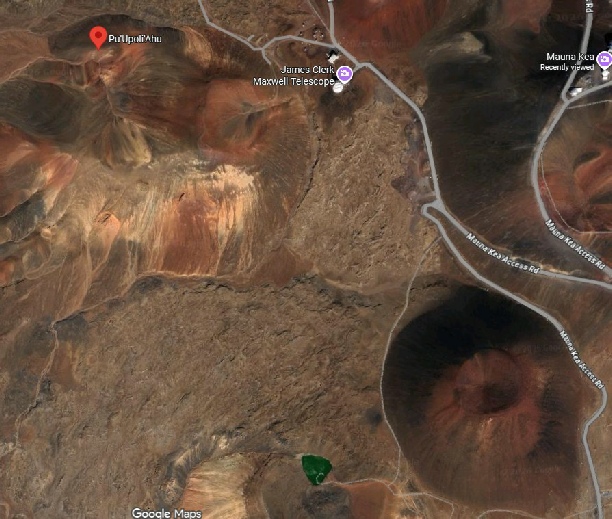
We have a location, but that lava field is big, can we be more specific?
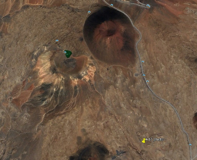
Yes. To cut a long story short, it was taken here:


It’s the Pu'u Huluhulu hiking area, at roughly 19.689906° North, -
So far so good. What bout the other image? It’s actually a composite of several images taken during Apollo 17, and that’s actually important. Here’s the panorama, which is made from photographs AS17-

It shows Harrison Schmitt (the other astronaut attendee at the conference. The view is of the south massif of Taurus-
The view behind John Young, conversely, covers a mere 2.5 to 3 km, of hills 1.5km away. I say “hills”, because while the feature on the moon is one large hill, the large hill behind Young is actually two, as you can see on the right.
The south Massif rises over 2000m about the valley floor, whereas the cinder cones in Hawaii manage only around 50 metres. They are, in short, mountains compared with molehills.
Something else that appears in the Hawaii photograph that doesn’t appear in the Apollo images: vegetation. You can see bushes and small trees in the image on the right, and in the one below. There’s even grass on the slopes.


Do feel free, hoaxter idiots, to point out where the trees and grass are in the Apollo photographs.
What you do get in the Apollo photographs are details on the South Massif that you can see in any number of orbital images taken after Apollo, but not before. These details aren’t on the cinder cones. The image below left shows China’s Chang’e-


I’ve adjusted the contrast to make the details stand out more. Sue me. Here’s the best pre-

Where’s the detail? Short answer: it’s not there. There are no pre-
So no, the photo of John Young is not of some sort of mock up of the Apollo 17 landing site. It isn’t anything like big enough, has too much vegetation, and is also very very public -
In a similar vein, there’s a video doing the rounds on Instagram and TikTok making similar allegations, and turning into the inevitable meme. Here’s the claim as reported in the Instagram post:
“A viral conspiracy claim has re-
He posted a short clip online detailing the location and claimed it matched set designs used in the Apollo program’s televised broadcasts. Within days, his social media accounts were deleted, and friends reported him missing. Authorities have not confirmed any foul play, but the incident has fueled speculation among conspiracy theorists who have long questioned the authenticity of the moon landing.”

Even the live TV footage (like this taken after the LM returned to orbit) shows the detail visible in the photographs and Chinese probe imagery.
Here’s one variation of the memes, clearly implying that were looking at Hadley Rille, the site of Apollo 15’s landing.

We can see what the entire mountain in the video looks like by taking stills from it.


Looks very volcanic again, and highly likely to be Hawaii. Let’s take a leaf out of the conspiracy playbook, seeing as it’s OK to say that if it looks like something then that’s what it is.
My belief is that this is from an area near Mauna Kea called Lake Waiau -

While there are many cinder cones that could fit the bill, this one has many features that coincide with the view in the meme, like the one seen in this one, from here.
I am, as always, happy to be proven wrong. Feel free to find an alternative location.

Many of the areas where these cinder cones can be found are criss-
This site has the same issues as the Apollo 17 claim: the area concerned is just too small to be the same location as the Apollo 15 site, and does not show the level of detail seen in the Apollo photographs.
A new variation on the theme appears with this claim:

The grid reference is just Mauna Kea, again, but apart from superficial similarity the two really aren’t identical -

Oh. Even the superficial similarity evaporates into the insubstantial -

No such plain. Just the uneven slopes of the volcano’s foothills, slopes discoloured by mineral deposits and dotted with vegetation -
It’s a dishonest claim made using a dishonest meme. Again.
Someone else who makes that dishonest claim looking at the dishonest meme is straydog02, to whom I have a page specially dedicated. He also simultaneously argues that Hawaii is both Apollo 15 and 17, so let’s take a look.
It doesn’t get off to a good start by continuously referring to the south massif he’s trying to liken to Mauna Kea as the north massif, but hey, geography isn’t for everyone.
Just so we’re on the same page, here’s the variation on a meme he’s discussing.
That claim seems to come from one David Bryant, see here, from a book where he also claims that extra-
Right.
Oddly, his book (and it’s garbage) makes absolutely no reference to that image other than including it at the end, complete with an image taken from 2001, A Space Odyssey that has a similar backdrop. The images are reversed.!
Let’s be absolutely clear: Apollo astronauts trained in Hawaii. The reason they trained in Hawaii is for exactly the reason straydog states, and that NASA and anyone connected with the Apollo missions states: if you want to train in how to deal with a rocky, dusty, volcanic environment, maybe take yourself to a rocky, dusty, volcanic environment.
This page is one of many containing photos of the training, and stray cites this document. The area next to Mauna Kea was evem labelled “Apollo valley” because of its use, but Kileuau as also part of the training process.
Stray (or rather the whatever AI package he was using that day -
While there’s no doubt as to his photo being in Hawaii, the actual cone is more, well, coney.
The image below left. shows the location of Pu’ u Poliahu. The image below right shows where I believe it the location from which the photo was taken.
The dropped pin shows where I think the photo was roughly taken from, and the resulting view in Google Earth is below.
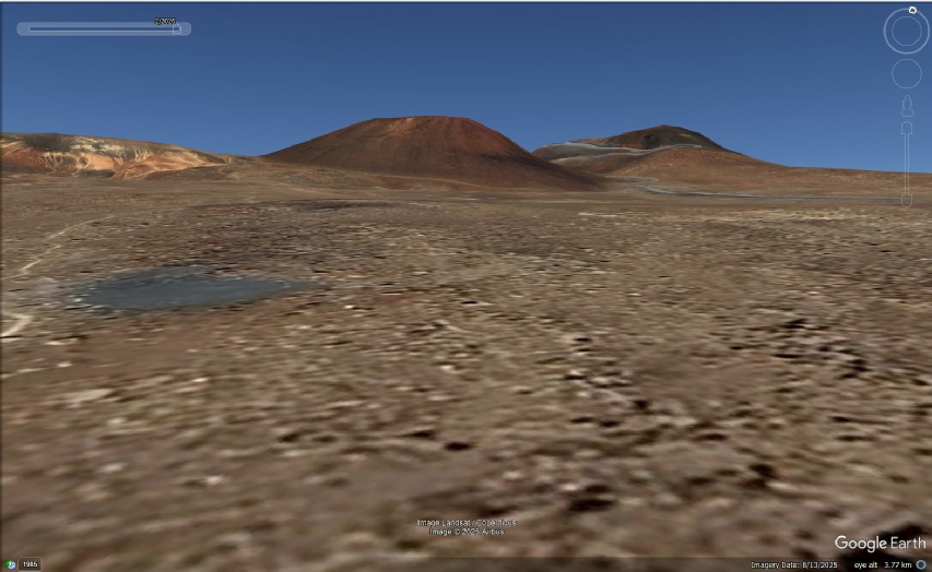
Note the grey patch, the light spot on the cinder cone, and the patterns on the ground of the landscape left of the cone, they’re all a match.
That cinder cone peak, from this spot, is roughly 1.6km away, and the cone itself is roughly 250 m across at the summit, 650-
This compares with the south massif’s 8.8km along the summit crest, and over 16km wide base, viewed from over 7km away at Apollo 17’s LM, or Mons Hadley’s 5km wide summit viewed from over 14 km away.
The cinder cone is right next to the main access road to Mauna Kea summit (where the other location stray mentions can be found), and approached from the south by the Humu’ula trail -
Straydog’s main contention is that this cone, and maybe others nearby, who knows, are specifically and simultaneously used for both Apollo 15 and Apollo 17 photos. He contends that it is exactly the same in every respect, and that details on it are present in Apollo iamges.
Bullshit.
Anyone who cares to can look at Apollo images and compare them with photographs taken by orbital probes from the USA, India, China and South Korea. Just like I did. Those probes confirm the details present in Apollo photographs as being visible in the orbital images. You can even get 3D data from those probes and reconstruct the views shown in Apollo photographs exactly. Just like I did.
Far from stray’s claim that Dave Scott, commander of Apollo 15, was able to identify features in Apollo 15’s landing site because he’d already seen them in Hawaii, he recognised them because he’d trained on models built from maps based on orbital images. Those orbital images didn’t contain precise details like rocks and small craters, but the later probes did, and they confirm the accuracy of Apollo.
He also makes claims about the science undertaken. He reports on Ground Penetrating Radar studies undertaken in Apollo Valley. GPR studies have indeed been done, but not before Apollo 15 -
“The Script: They then mapped these specific "fingering" layers of cinders and gravels. When the astronauts later "found" identical layering in the walls of Hadley Rille on the Moon, they were following a geological model that had been fully mapped in Hawaii first.“
He’s suggesting some sort of time travel. Layering was indeed observed on the wall of Mons Hadley, but when they built a cement model of it based on the photographs taken during the mission, they found it was purely an artefact of lighting. His claim is false, and relies on modern studies and data being applied to something that happened decades earlier!
Statements like:
“The Apollo 15 Flight Data Logs and Landmark Maps show that the astronauts didn't just guess what the Moon would look like. They were briefed using a 1:1 visual script created at Mauna Kea.”
are just projection. These are the actual landmark maps. Anyone who is able to visualise what a landscape looks like form a contour map will be able to do some from these, particularly when aided by orbital imagery. His detailed description of the view during his stand up EVA reference points from those maps.
All in all, yes, they trained. They practiced processes and procedures in a similar environment. That training was applied on the moon, where volcanic mountains and landscapes look like other volcanic mountains and landscapes.
All these people have is “this mountain looks like that one”. Yes. They do. “Looks like” is not the same as “is”. The conder cones of Mauna Kea may have similar profiles as the landscape of Mons Hadley and Taurus-