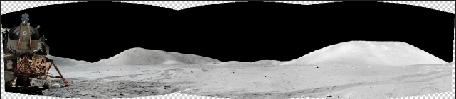
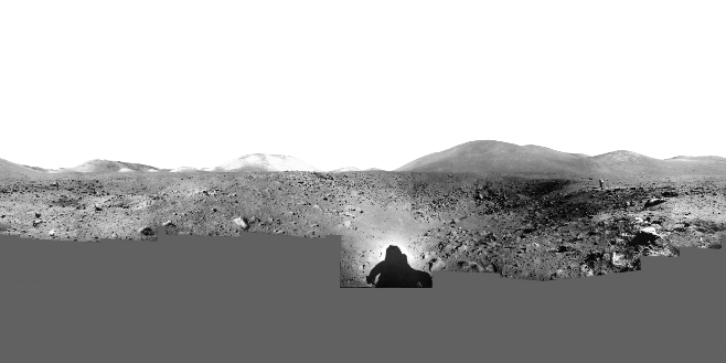
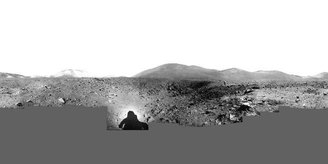
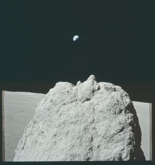
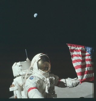
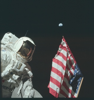
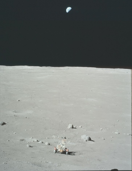
There’s very obviously some filling in of missing sky. Still sceptical? Let’s take one of the photos taken at the flag showing Earth and superimpose it on the south massif, using the same points on the landscape to get the alignment correct.
Fancy software wasn’t around when the Apollo missions were, so these panoramas were hand assembled. Here it is on the ALSJ site:
This version is from the Geology report, a physical copy of which I own.
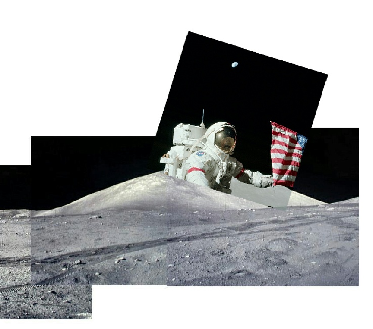
The Earth is very obviously not in the field of view of the camera.
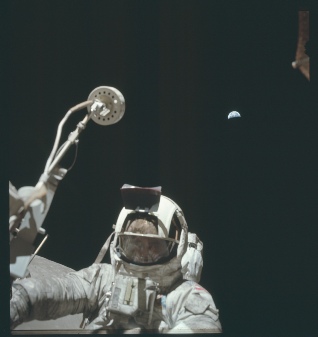
Stray tries to make a big deal about the that field of view, claiming that the Hasselblad 60mm lens used only has a 47 degree view, but seems to forget that a substantial amount of that field here is made up of the ground. Even he says it’s not reliable:
“You also can’t derive altitude angles reliably from a wide-
He also says that
“the photographer had to either bend down, or get on his knees”
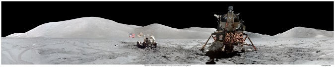
to get the photos. Which is exactly what they did (see below).
It’s worth reminding everyone here that initially he was happy that Earth was correctly placed!
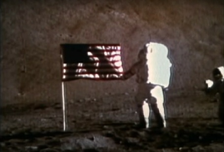
Earth is exactly where it should be. 45 degrees above the actual horizon.
Now that he’s edited all his previous comments, it’s started to become increasingly difficult to edit this document without it getting overly complicated. With that in mind I’ll add new things at the end.
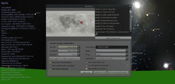
One of those new things he’s added is that his critics are configuring the Virtual Moon Atlas software incorrectly when deriving values of libration. He’s insisting that people are configuring for the lunar centre rather than surface (topocentric) values. Yet again, he’s displaying that he’s never been anywhere near the software. The VMA does not place itself on the moon. It is specific to views of the moon from Earth. Yes it does have a topocentric option, and this will affect the libration values, but he hasn’t demonstrated that people are doing it incorrectly.
It does not show the position of the Earth above the South Massif, nor does it ever “confirm the high elevation”. Prove me wrong.
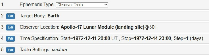
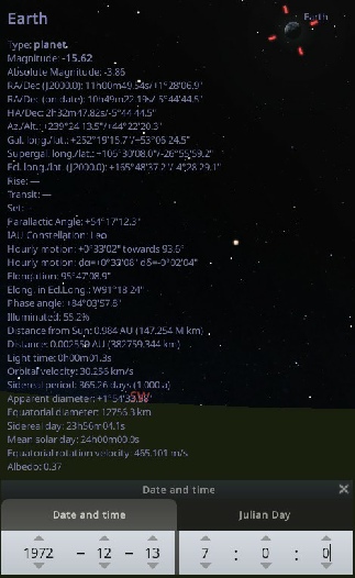
The column we need is the ‘Elev’ column, which reads from a minimum of 44.02 degrees to a maximum of 45.28 degrees. The gold standard fundamentally contradicts straydog’s claims.
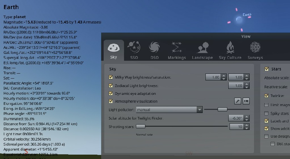
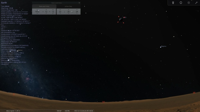
Now for Stellarium. Stray insists that Stellarium shows his 70 degrees figure, and that the reason nobody else gets that value is because we’re all doing it wrong. Here’s how we all, apparently, have been doing it wrong:
“This [45 degrees] is impossible, because Stellarium itself uses the JPL DE ephemerides, the Moon’s rotation matrix, and topocentric geometry. When set correctly, it ALWAYS reproduces the same result as SPICE within <0.3°.
Stellarium has two Moon observers:
Center of Moon (wrong!)
Topocentric surface point (correct)
Your troll’s friend 100% used the center of the Moon, which drops Earth altitude by ~25°.”
Apparently, we should also turn libration off.
Well, for a start I have yet to find anywhere in Stellarium’s set up that allows libration to be turned off. He gets confused a lot about libration (or at least, his AI is inconsistent. In one post he’ll say it’s insignificant (usually when using a strawman argument to claim that this is why his opponents claim a 15 degree change in elevation over the mission -
“Earth’s apparent position shifts by several degrees due to lunar libration”
In his world it’s simultaneously hugely important and not important at all as an explanation as to why Earth is higher than his opponents are claiming.
He also seems to be claiming that adding libration “double counts” Earth’s movement in the sky, because lunar longitude apparently relates to the sub-
“The 45° result is wrong because it double-
It’s not difficult to get confused here. While some scientists are arguing to fix the meridian on a physical feature, the current accepted consensus is to use the ‘mean sub-
As you can see, there’s no real variation at all, certainly not the 25 degrees stray thinks should be happening because we’re all so incompetent at using it, and it’s nothing to do with him having never used it at all and relying on force-
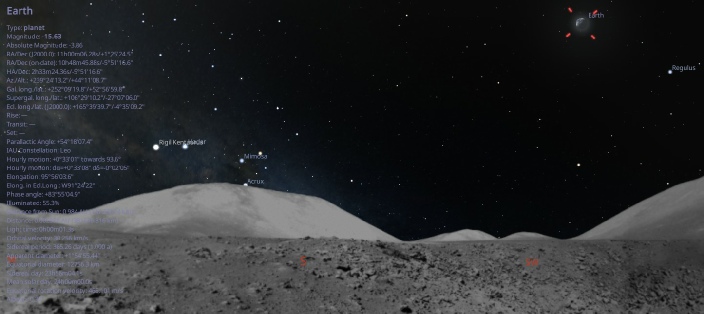
The other thing you’ll notice there is that there isn’t a lunar surface visible. You can change Stellarium’s landscape to match where it say you’re viewing, and stray has become convinced that this landscape is what the software is somehow measuring. He’s at least moved on from claiming that the 45 degree figure is because it was measuring from orbit.
It is not the landscape.
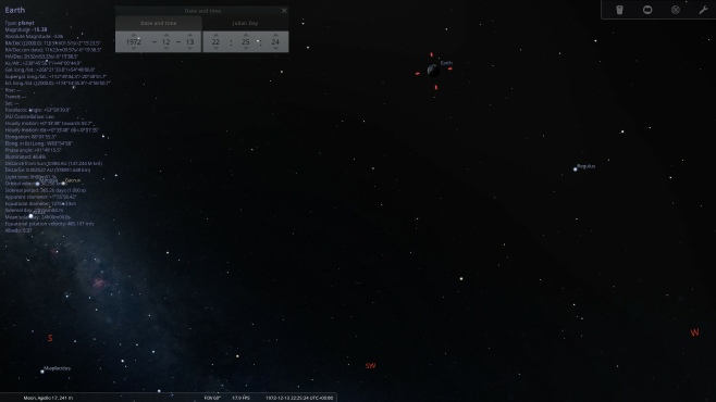
The landscape files for Stellarium use a simple ‘.png’ file, referenced in 3D space by other software and imported into the program. The software absolutely does not reference that imagery when calculating the various coordinates available to you as a user. Here’s the same scene presented with and without the landscape.
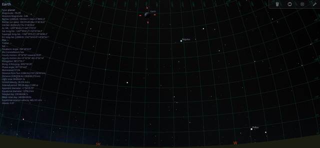
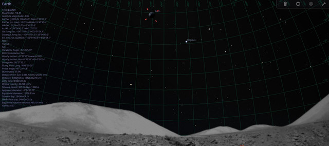
Absolutely no difference whatsoever to the figures it generates. Zero. Because it’s looking at a set zero datum that has nothing to do with whichever arbitrary choice of landscape you want. You might notice the grid superimposed on the view.
You might also notice which lines intersect Earth. It’s not 70 degrees, or even 50. If you’re really observant you’ll spot that the first visible line on the Apollo landscape isn’t zero -
Here they are superimposed.
Later on in the discussion her returns to Stellarium, and claims to have solved the problem. Again. Yet again it takes no time at all to demonstrate that he’s done no such thing. He specifically references this image on a metabunk forum post about the same topic. It’s actually my post! After agreeing that it says 44 degrees or so for the elevation of Earth, he has this to say:
“The ground / terrain is ON
You are measuring altitude relative to a local landscape horizon
That landscape is not the true lunar horizon
At Taurus–Littrow, the South Massif rises ~2 km above the landing site, and from that distance it subtends ~8–12° of vertical angle.
That means:
Stellarium’s “Alt” here is measured above the visible terrain, not the geometric lunar horizon.”
And
“Why Metabunk (and others) land on ~45°
Because they are effectively measuring:
Earth altitude above the local skyline
not
Earth altitude above the Moon’s true horizon”
Sigh.
He then gives instructions as to how to cure this egregious error:
“How to prove this to yourself in 10 seconds
In Stellarium, with everything else unchanged:
Press G → turn Ground OFF
Press Ctrl+G → turn Landscape OFF
Now click Earth again.
You will see: Altitude jump from ~45° → ~53–54°”
Let’s see that in action:
Here’s something else the document he’s using contains (despite later claiming no documents at the ALSJ do this, and his pet AI package was similarly unable to find) -
He now insists that the ALSJ says it’s 54 degrees. It does not.
He later claims that these elevations show Earth elevation
“In the LM reference frame”
And not above the true lunar horizon. That’s a) meaningless, and b) simply not true -
Stray makes a big deal about my modifying the landscape. Apparently that’s a “red flag”, and I have “admitted” changing it. Conspiracy nuts love to say you’ve “admitted” something. It makes it sound like they forced it out of you at gunpoint and it’s a victory for them. What he means by “admitted” here is that I found a problem with Stellarium’s landscape, fixed it, told everyone I’d fixed it, and gave them the files so they could use it themselves. My making of that change made not one iota of difference to the elevation figures, it just made the view look more correct, as you can see below. The top line is the two png files used by Stellarium, with the original configuration on the left. The latitude/longitude figures are give from the landscape.ini file.
And here’s how that translates into the view using exactly the same date and time (13/12/72, 07:00).
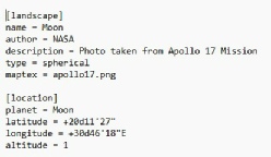
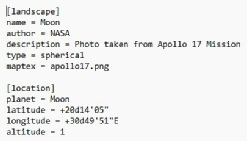
Earth is now more correctly positioned, but the values displayed on the left are unchanged. Stray’s claim that Stellarium is somehow mistakenly reading the top of the south massif isn’t helped by the original positioning of Earth being nowhere near it!
There’s a lot of discussion about Stellarium, and how everyone else is using it wrong and if only you use it properly there you’ll get the figures he wants. Not once has he ever done that. Nowhere does he do what I’ve done above: provide an illustration of the numbers. It’s “trust me bro” -
He claims that users aren’t turning off atmospheric refraction for the moon, and that his has a result. There’s no such setting. There is this, but hey guess what, it has no impact on the result.
Turn the atmosphere on for the moon, and the sky turns blue, but the Earth elevation stays the same.
He demands people post screenshots of the settings used and the figures for Earth -
As for using the topocentric surface, it’s enabled by default in my version. What it does is ensure that you’re getting azimuths and altitudes relative to your position, rather than the point measured from the moon’s gravitational centre. In reality, turning off that figure does very little to the Earth’s altitude -
No sooner has he made that final post on the matter than he makes another one. He says:
“1. Backgrounds: I never said the background image changes elevation.. It doesn’t.. The issue is the horizon reference.. Terrain vs geometric, not the picture.”
Except he has said that, several times. Stellarium always works from a horizon reference. Then:
“2. Stellarium: Turning Ground off only hides the drawn ground.. If a landscape/terrain is still active, Stellarium is still using the raised skyline as 0°.. That’s how you end up with ~45° instead of the ~53–54° geometric altitude.”
Turning off the ground is EXACTLY WHAT YOU JUST TOLD US TO DO. There is no landscape reference involved.
3. Horizons: There absolutely is a Moon-
Do feel free to show us where it is. It isn’t where you claim it is. And topocentric frames are exactly what you told us we should be used. Which is it?
4. Distance: Saying EVA-
Strawman. No-
He should check that his AI isn’t full of shit before he posts, because all that’s happening here is he’s making himself look even more stupid and lazy than he is.
Quite the feat.
He continues to tie himself in knots over on Jenny’s channel. He claims that:
“Turning on the azimuthal grid doesn’t give you the true lunar horizon if terrain is enabled.. The grid is drawn relative to the terrain horizon, not the geometric horizon.. That’s why Earth sits on the 45° circle — it’s 45° above the raised skyline inside Taurus–Littrow. Turn Ground OFF and Landscape OFF and the altitude jumps to ~53–54°, which is the true horizon altitude.”
And
“Turning Ground off hides the drawn ground ..It does not remove the terrain horizon.
If a landscape is still loaded, Stellarium continues using the raised skyline as 0°, which is why you keep getting ~45°.
When both Ground and Landscape are disabled, the altitude jumps to ~53–54°, which is the true geometric horizon altitude.”
As you can see above, none of that is not true. The grid starts at ground level at 0 degrees, regardless of landscape.
He even says:
“Switching to a flat landscape (Ocean, Zero Horizon, None) immediately gives the correct ~53–54°.”
Which is exactly what’s been done above, and it does not do what he says it does..
He’s not even readnig his own AI output properly, if he did he would see it’s telling him he’s wrong. IN answer to a point made by Cleric_58 he says gives this:
“The Alt/Az grid in Stellarium is not tied to the visible terrain.. It is drawn relative to the mathematical horizon of the active landscape, which can sit below or above the rendered terrain.”
Yep. That’s what we’ve been telling you, and not what you’ve been telling us!
Speaking of the view, his next big “a-
The image on the left is my recreation of the one at Metabunk. There’s a real clue here that straydog hasn’t done thing he’s claiming will answer this puzzle once and for all.
IT’S FUCKING MARS.
The landscape being used in Stellarium is Mars, not the hilly landscape of Taurus-
Statements like this:
“That Stellarium screenshot is showing Earth at ~45° because terrain is turned ON.. That means the altitude is measured above the local valley walls, not the Moon’s true geometric horizon. Taurus–Littrow is surrounded by 1.5–2 km massifs that raise the visible skyline by about 8–12°...
When you turn terrain OFF (G and Ctrl+G), Stellarium immediately shows the correct geometric altitude of ~53–54°, which matches NASA’s mission geometry and JPL Horizons”
just prove he’s never been anywhere the software and really hasn’t thought his claims through.
Need more? Well, if you read through his instructions you’ll see that I’ve turned off the ground (‘G’) in his instructions, but not done his second one. Why?
Because Ctrl+G just resets your viewing observation as Earth, that’s why. The only other landscape options relate to labels and illumination, and which l landscape you want to use. Not one of these options changes the elevation of Earth above the landscape.
He expands on the “LM reference frame” arguments where he concedes that, despite arguing until he was blue in the face that it absolutely had to be 70 degrees, it should actually only be 54 degrees. Or at least he gets Grok to admit it on his behalf.
Groks mistake, apparently, was to
“ LM tilt antenna mounting offsets and body-
This is just word salad, with a dressing of bullshit. It’s meaningless. The initial figures in the press release quoted above were pre-
He even says this in relation to those values:
“Earth is rising slightly each EVA. .. That matches: LM attitude changes and libration trend, NOT a fixed surface horizon.”
Again, wtf? Yes, Earth is rising slightly over the course of Apollo 17’s stay exactly because of libration trend, but attitude changes? The LM is moving? Maybe read your AI output to see if it makes any kind of sense before posting. He suggests that it’s actually the lunar modules “6-
He returns to the subject of the antenna in what he believes proves his point some time later (it’s one of those occasions where the subject is closed, apparently, but he does keep returning to it). His first points in his comment are substantially correct, he talks about the need to re-
3. The "45° Marking" Misconception
There were indeed graduated scales on the antenna assembly to help the astronauts find the Earth quickly. However, these scales measured the angle relative to the Rover's chassis, not the lunar horizon.
If the Rover is parked on a 10-
Trolls often see a "44" or "45" mentioned in a transcript or on a dial and assume it is a fixed astronomical constant, rather than a local adjustment for that specific parking spot.
Again, there was no graduated scale on the HGA, and again, he is making a claim that the rover is pointing uphill on a 10 degree slope. To be fair, there is aoms discussion about the steepness of the Station 6 site at Tracy’s rock, see here. The crew make several references as to how steep it is, and there’s this note on the ALSJ page:
"Upper slopes of the massif, 20 to 30 degrees; lower slopes, including Station, 6 to 11 degrees. In and around the largest Station 6 boulder, slopes vary all over the place, from 11¡ over a broad area, to 20¡ where the regolith is pushed up around the boulder.”
We can’t be certain as to the exact incline, but we do know what angle it was parked at:
“164:51:24 Cernan: Okay. We're parked on a heading of 107”
That very much agrees with photographs of the rover at station 6, with the rover pretty much sideways on to the South Massif.
More importantly, his referring to the graduated scale shows he still doesn’t understand the subject, and hasn’t checked which instrument it’s on. Fact checking isn’t a thing for him. Yes, the scale is on the rover, so if the rover is on a slope it will affect the result, but for the 10 degrees to be valid the rover needs to be on a 10 degree slope in the direction the angle to Earth is being measured. If it’s side on to that, it’s completely different! It’s also completely different if the rover is on a slope going in a different direction, which (as we can see above) is the case at Station 6 on the North Massif.
Early exchanges relate to his insistence that popular astronomy software Stellarium, NASA’s own website where lunar ephemeris can be calculated, and even the Lunar Reconnaissance Orbiter website vindicate his stance.
Let’s deal with that one first. Here’s what he has to say:
“LROC QuickMap (Arizona State University): This tool, based on Lunar Reconnaissance Orbiter data, shows Earth high in the sky (~70°) when viewed from the Apollo 17 site at EVA times.”
And
“LROC Quick Map: This tool uses actual Lunar Reconnaissance Orbiter topographic data. If you use the "Sun/Earth" tool on Quick Map at the Apollo 17 site, it confirms the high elevation.”
OK then. This is the only possible thing he can mean at the quickmap.
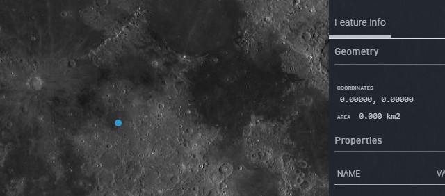
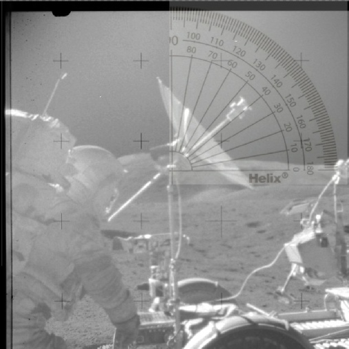
He also conveniently ignores all the positions in the valley where they were very much level, like this one taken at station 4 on the ‘Tortilla flats, on which I’ve superimposed a protractor.
What angle is being bisected there stray?
So while this point is always the 0/0 seen here on the right, It is not always the exact centre of the moon’s face relative to Earth.
The coordinates of Taurus-
Oh no! You can’t see Earth, it must be fake!
It doesn’t seem to occur to him that the black sky might have been filled in by the Moonpans website in creating the panorama. In this part of the Moonpans site, the construction is explained:
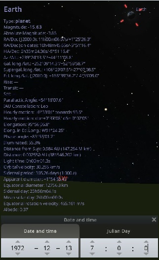
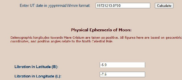
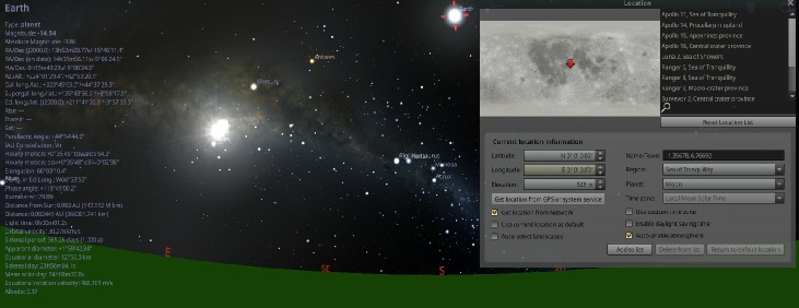
Setting the VMA to show how the moon appeared on any of the dates during the Apollo 17 EVAs gives you libration values of -
Again, that’s the moon’s movement as viewed from Earth, but it does generate values that you can use to calculate where the Earth will appear, as demonstrated very well here using VMA figures.
He’ll claim in one post that this calculator uses MEAN_ME and dismisses the results, but there is nothing on that page to justify that claim.
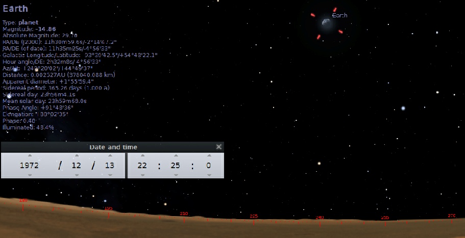
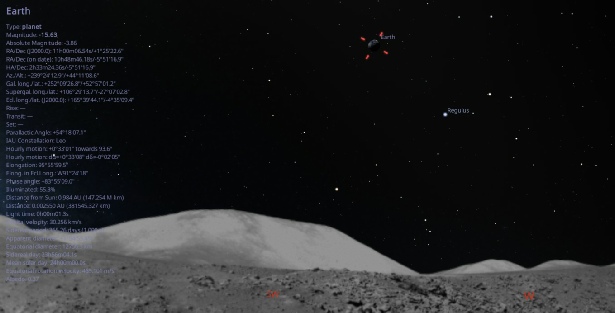
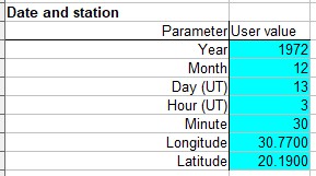
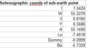
Now for NASA/JPL ephemeris figures, which he calls “the gold standard”. You need to go to this website and type in the relevant values.
Which gives you: the figures below:
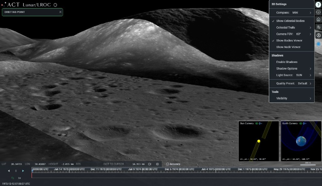
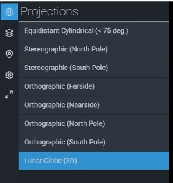
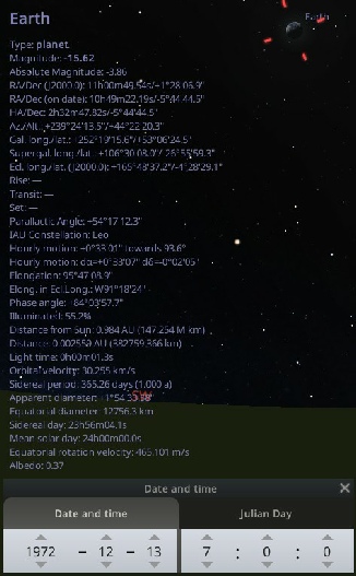
By changing the projection to ‘Lunar Globe’, it’s possible to set your location to a specific spot and rotate around it. You also have the option of entering a start date, and displaying the Earth. Here I’ve set the start date to coincide with Apollo 17, and I’m rotating around a point in the Taurus-
The green hills of Earth part 1
NB: Many of the comments quoted here have since been deleted by straydog, ostensibly to tidy up his channel comments section, and to remove things that aren’t actually correct. It does have the added bonus, for him, of hiding all the fuck-
This topic that has created a lot of comment as he backs and forths with the occasional person who isn’t actually him in his comments section.
It’s based on a throwaway comment made by Gene Cernan in this video:
“[Earth] was very close to the horizon on Apollo 17 and that was unique for us we didn't have to look up like most of the other flights from most of the other Landing sites were to look at the Earth I mean I just glance over my shoulder and there's the Earth.”
Now, anyone who knows anything about Gene Cernan is he loves a good yarn, and his tales have been told so often they can take on a life of their own. Stray takes issue with that “close to the horizon” quote, partly because his own subjective interpretation of “close” doesn’t match with what he understands to be available in the Apollo photographic record.
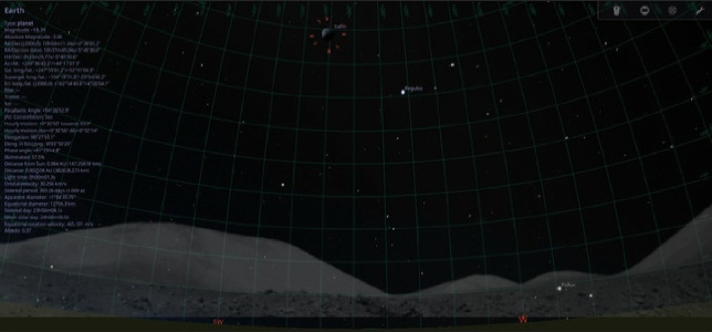
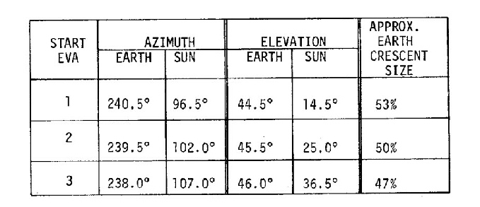
Initially he seems content with the figure recorded in Apollo documentation, like this table.
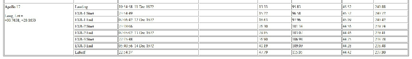

Hilariously, he mistakes the sun’s altitude for the Earth, claiming a huge change in altitude over the course of the EVA. His main objection comes from the fact that his idea of close to the horizon differs. In fact at one point he states quite specifically that the Earth is exactly where it should be in the Apollo photos.
Here are some typical views from magazine 134 and 137.
Things take a turn when he tries to do maths. Or at least get a range of AI packages to do the maths for him. As far as he is concerned, his new figure for where Earth should be is around 70 degrees above the horizon, based on the simple premise that the Taurus-
Add to that the natural wobble of the moon in relation to Earth (libration) and there’s a little more variation. He knows that exists, but all he manages to do is subtract libration values from his false 70 degrees figure to produce answers that are still incorrect.
At one point he claims the Apollo lunar Surface Journal makes references to a figure of 60-
Another claim he had to backtrack from (or pretend that it was a trap!) was that the elevation of Earth wasn’t ever mentioned, and certainly not 45 degrees. The obvious response to that is to quote this from the transcript:
“142:44:42 Parker: You might check the low-
…
142:45:00 Cernan: Okay. Yeah, we are at 45 degrees (low-
Stray’s response to that is to go into a long discussion about how the earth elevation is actually just antenna elevations, nothing to do with Earth. Except he seems to think it relates to the High Gain Antenna (HGA), not the Low Gain Antenna (LGA) referenced by Cernan:
“The HGA elevation angle is a mechanical angle internal to the antenna mount, referenced to the rover/antenna assembly, not to the lunar horizon.”
“As we discussed before, the LRV high-
He also references a specific document that deals with radiation management, quoting text that does not appear any within it. He does at least mention this document as a source, which does have relevant information in it. When combined with this document we can get a proper picture. Dealing with the antenna he thinks we’re talking about, the HGA is the large umbrella like piece of equipment that needs to be pointed pretty precisely at Earth in order to work. The LGA is not used for TV signals, just for maintaining voice communication when the HGA isn’t available,
The HGA is aligned by first getting a rough alignment by eye, then using a combination of a boresight and a meter indicating S-
As far as the LGA (with its much broader 30 degree tolerance) is concerned, that does have markings on it, but the documentation says this:
“The antenna elevation (lunar surface to earth) is set by unlocking the elevation adjustment lock, tilting the antenna at pivot point to desired elevation angle, and re-
The bold emphasis is mine, but the reference is specific. What stray is trying to imply is that the rover is on a slope, and the 45 degree angle is what’s needed to compensate for that slope.
There’s also this, alongside an instruction for initial set up process “set LGA to a [To Be Determined] degrees”:
“LGA elevation setting is a onetime adjustment since the RF beamwidth adequately covers pitch and roll movements during LRV traverse. “
So while the HGA needed adjusting all the time, the broader beam of the LGA meant (in theory) that it only needed doing once. Then:
“Point LGA at earth by using the staff lower handhold for azimuth adjustment.” and “Verify that LGA is pointing toward earth.” And “Keep LGA manually pointed within ±30 degrees to earth. “
No boresight involved there, just point it roughly at Earth.
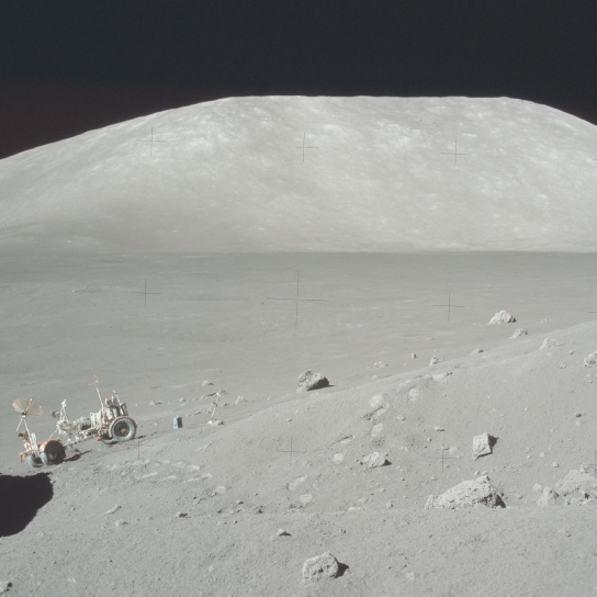
Luckily we have a couple of good photos of the LRV in place at Station 2, so can have a look at the set up.
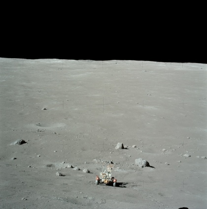
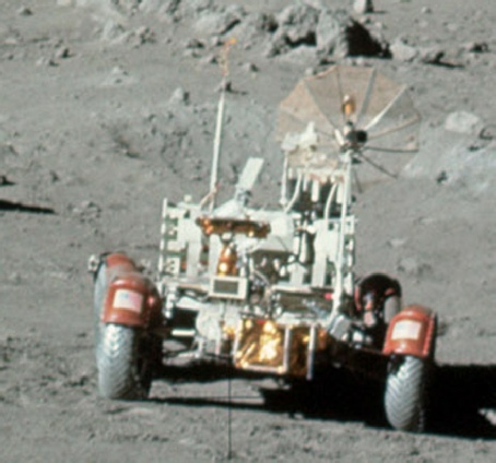

The HGA antenna here is pointing at Earth, which is out of shot, but by lining up features on the horizon (in AS17-
It’s ballpark, but it’s what the antennae are pointing at. Prove me wrong.
In order for an Earth 70 degrees above horizontal to be reading as 45 degrees, the rover should be on a a 25 degree slope. That’s steeper than the actual South Massif.
We also have a direct reference to the LGA in the cuff checklists as part of setting up the LRV -
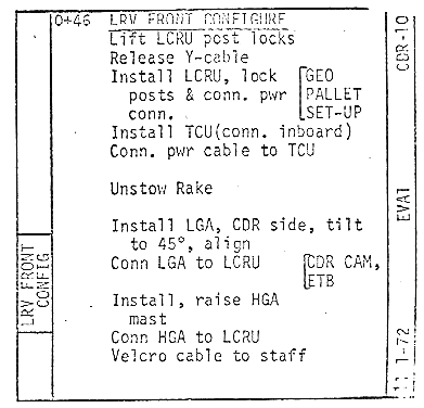
Oh look. 45 degrees.
Here endeth the first part of the lesson
We can also use the spreadsheet linked to on this page to work out the sub-
Which give longitude (“Lo”) and Latitude (“Bo”) figures that very much match the values above.
 Part 2
Part 3
Part 2
Part 3