The green hills of Earth part 1a: How not to use Stellarium
NB: Many of the comments quoted here have since been deleted by straydog, ostensibly to tidy up his channel comments section, and to remove things that aren’t actually correct. It does have the added bonus, for him, of hiding all the fuck-
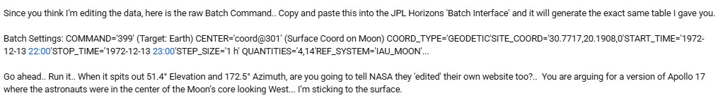
For a start, he’s missing out the start of the command which is the link to the API: https://ssd.jpl.nasa.gov/api/horizons.api?format=text&
Though to be fair youtube can be funny about web links. He’s also missed out all the ‘&’ ampersands to separate each instruction (to be fair, some are needed, some aren’t), and you need to edit out his ‘hints’ (eg ‘Target: Earth’).

Here’s what we get:
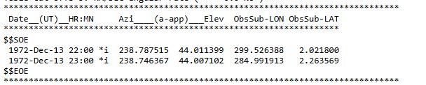
Want to run that by us again stray, because my values, using your code (when properly formatted) and the IAU_MOON reference frame you’re so keen on show the azimuth and elevation exactly where it should be, and not where you said it would show us. Copy & paste my code in to a web browser, prove it yourself.

Oh look, it made no difference whatsoever. Again.
And for even more fun, let’s put the coordinates at the Apollo site preset
Same values again.
It does, however, understand ‘REF_FRAME’ when using IAU_MOON, so let’s try that:
Very important to note that the only thing I’ve done is correct his formatting and his reference frame error. The dates and location underpinning the ephemeris are exactly as he’s typed it.
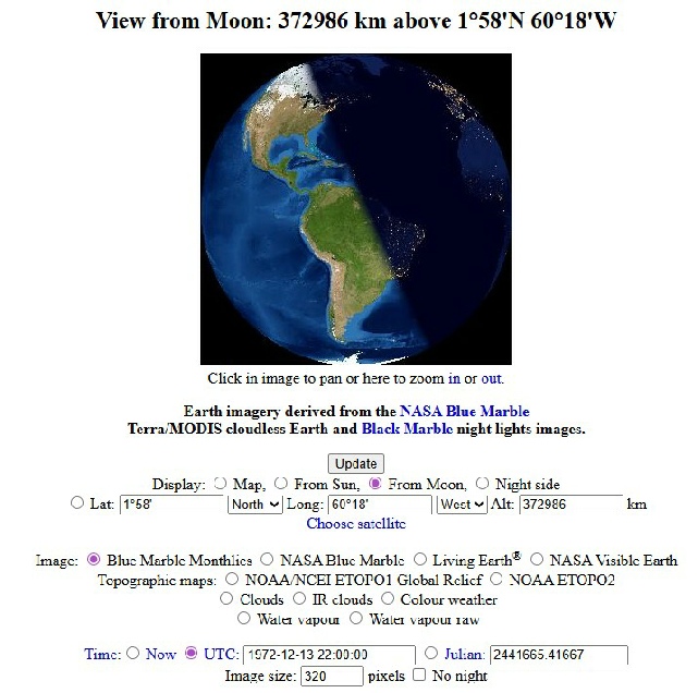
What happens if we make it so that we are actually looking from the lunar centre? The moon’s radius is given as 1737.4 km, so if we set the observer -
The azimuth is now slightly away from north, and the elevation is just shy of 6 degrees. This seems counter-
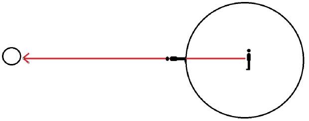
It’s exaggerated for effect and you need to get your brain working in 3 dimensions, but you get the idea. More importantly, in terms of stray’s misunderstanding of those dimensions, you can’t place the observer at the lunar core in a geodetic coordinate system and generate results. It just doesn’t like it.
The end result is: it doesn’t matter how you mess with the values you put in to Horizons, it is pretty much impossible to get the values stray does without doing it deliberately.
And so it continues. Stray has seen Cleric & Jenny’s reposting of my comments and their own use of the Horizons API. Stray thinks he’s spotted something:
Look at your own data header.. It says 'Target radii : 6378.137 km'. That is the radius of EARTH, not the Moon!.. You have the observer settings wrong.. Because you didn't define the surface correctly, Horizons is giving you the Geocentric (Core) value.
It’s difficult to describe how stupid this is. Yes, the target radius is of the Earth. BECAUSE THAT’S THE FUCKING TARGET!
The observer settings are set as the ‘center’ settings.
He then insists we’ve all been doing it wrong again, and sets out why on his own channel. It doesn’t help that he completely misunderstands the data. Again.
Here’s what he thinks is a rebuttal:
“1. The "Far Side" Longitude Blunder...
Look at your own data line... ObsSub-
As usual he’s confusing what he’s looking with where he’s looking from.
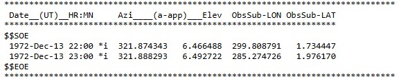
The ‘ObsSubLon’ figure is the longitude of the centre of the object you’re looking at. Here’s what it says in the readout:
“ObsSub-
So when you look at the Earth from the moon, it’s the coordinates of the centre of it, as this will vary with axial tilt and so on.
He’s also got very very confused about what a longitude of 299 degrees is. It’s not the backside of the anything -
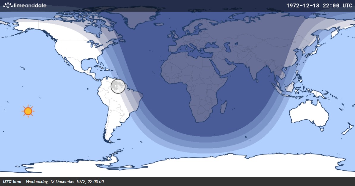
If you try and use the surface coordinates of Apollo 17 but still shift the observer point 1737.4 km underground,
Because you’re looking at Earth like this:
Exactly where it should be.
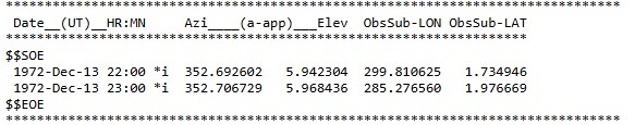
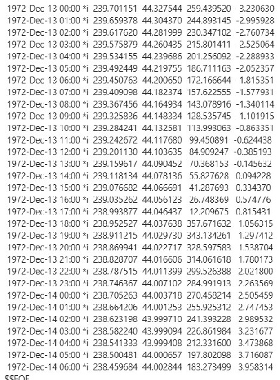
If you look closely at the values above there’s a second ObSubLon an hour later -
He then takes issue with the reference frame:
“2. The Reference Frame Fail (MEAN_ME vs. IAU_MOON)...
Your output explicitly states.. Center pole/equ : MEAN_ME (high precision). MEAN_ME is an Inertial frame (Mean Earth/Mean Equator).. It is used for orbiting satellites.. It does not rotate with the Moon’s crust and mountains.
IAU_MOON is a Body-
And also
“Your API ignored your REF_FRAME command and defaulted to MEAN_ME.. That is why you are 300 degrees off in longitude and 60 degrees off in azimuth.”
Except we’ve already demonstrated that you can’t add IAU_MOON in the way he claims to. As he hasn’t posted any of his actual output we have no way of verifying what his output is, only that he’s wrong. It does indeed quote MEAN_ME in the output. Wonder if his does? I’m betting we’ll never know. He also still doesn’t understand what MEAN_ME is -
“It is not suitable for high accuracy applications (eg precise lunar landing) due to truncated data, with errors in the range of ~70-
So by all means use a lower accuracy coordinate system, it’ll just put your observer a little way off the genuine location, but it won’t change the fact that the azimuth and elevation produced by Horizons are correct when I use it and wrong when he does.
He claims that we’re using a December 12th date to produce data for the 13th, when in reality we’re using exactly the dates he specified in his string. Anyone with eyes in their head can see both dates and times used there are December 13th.
It’s hilarious that he says this:
“Stop hiding behind API strings you don't understand.. Go to the JPL Horizons Web Interface, manually select IAU_MOON, and watch it spit out 51.4° Elevation and 172° Azimuth.”
When his API strings don’t actually generate the values he’s claiming but he didn’t even add the instruction to produce the ephemeris, and he completely misinterprets the results we’ve produced. We did everything right, and got the right numbers. He never has. Apparently we need to go the web version instead because we’re so bad it this, and then we can choose IAU_MOON from there. Except you can’t. There’s nowhere to choose it.
The only thing he gets right in his rebuttal is this:
“The Physical Reality:
The Earth is directly above the South Massif”
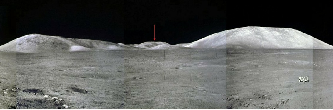
Absolutely right. The South Massif, in the southern half of the Taurus-
Apparently by agreeing that Earth is above the South Massif we have debunked the photos -
Exciting times people, exciting times -
1. The "Far Side" Longitude Blunder
You claim you configured the software correctly?. Then explain your Longitude.. Your own data (and Jenny's) shows ObsSub-
Already done. You don’t understand what the value means.
2. The Reference Frame Fail (MEAN_ME vs. IAU_MOON)
Your data header confirms you are using the MEAN_ME frame.
MEAN_ME is an inertial frame used for satellites.. It treats the Moon as a non-
IAU_MOON is the body-
On Dec 13, 1972, the Moon’s libration tilted the Taurus-
Citations required. I’ve already given you mine. You’re just wrong. Show the class how to choose the less accurate IAU_MOON in Horizons.
Here’s what I got back (right).
Once again it doesn’t understand what to do with ‘IAU_MOON’ as a ‘REF_SYSTEM’. Nor does it generate any ephemeris data.
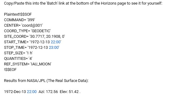
Let’s try this instead:
!$$SOF
COMMAND= '399'
CENTER= 'coord@301'
COORD_TYPE= 'GEODETIC'
SITE_COORD= '30.7717, 20.1908, 0'
START_TIME= '1972-
STOP_TIME= '1972-
STEP_SIZE= '1 h'
QUANTITIES= '4'
REF_FRAME= 'IAU_MOON'
!$$EOF
Here’s what I got back:

Looks like it doesn’t understand IAU_MOON there either.
And oh, what’s this?
Want to run that by us again?

He keeps doubling down on his assertions on Jenny’s channel.
“I know exactly what ObsSub-
There are two main ways to map the Moon.. MEAN_ME (an 'average' orientation) and IAU_MOON (the 'physical' orientation that includes the 7-
In the MEAN_ME frame (the one OBM uses), the Earth's sub-
The Earth's position shifts significantly away from the 'Mean' center because it accounts for the physical tilt and rotation”
Again he’s showing he doesn’t understand the coordinate systems and how they work. Both systems aim to provide a fixed, permanent set of coordinates. 0,0 is always the same in both. The debate is how accurate those systems are. It is universally acknowledged, including by JPL Horizons, that IAU_MOON is less accurate. And it’s not me using it, it’s Horizons -
“When your script says the Earth is at 0^ longitude, it’s using a theoretical Moon that isn't wobbling.. When my script says 299.5^, it’s using the real Moon that the astronauts were allegedly standing on.”
It’s not my script doggy, it’s yours. It doesn’t say the Earth is at 0 longitude -
“If you use a frame where the Earth is at 0^ longitude (360^), you get an elevation of 44°.. If you use the frame where the Earth is at 299.5^ longitude (the physical reality), you get the correct elevation of 51.4°.”
Except you don’t.
“Answer this.. If the Earth was at 0 longitude like your 'average' math says, why do the Apollo 17 photos show the Moon tilted so far that the Earth is 7 degrees higher than the average?”
It isn’t at 0 longitude, and the Apollo photos don’t show that.
Just for fun I sent this command to Horizons:
!$$SOF
COMMAND= '399'
MAKE_EPHEM = 'YES'
EPHEM_TYPE = 'OBS'
CENTER= 'coord@301'
COORD_TYPE= 'GEODETIC'
SITE_COORD= '30.7717, 20.1908, 0'
START_TIME= '1972-
STOP_TIME= '1972-
STEP_SIZE= '1 h'
QUANTITIES = '4,14'
REF_FRAME= 'IAU_MOON'
!$$EOF
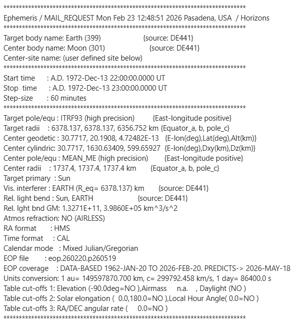
The QUANTITIES element specifies the output you want, 4 being the azimuth and elevation, 14 being the Observer longitude and latitude. This time the values cover hourly figures for the entire duration of their stay. Here’s the output. Stray disputed jenny’s ouput showing something similar because she didn’t show the header, so here it is included.
Here’s another thing in the email output:
Remember this quote from him? “Topocentric surface point (correct)”.
Take a step back stray. Take a breath. There’s no shame in admitting you got it hopelessly and catastrophically wrong and that you’re way out of your depth. We might just stop thinking you’re a clueless dickhead.
Well, he didn’t take a step back. He posted instructions, so let’s have a go.
Here is exactly how to find it...
Go here first: https://ssd.jpl.nasa.gov/horizons/ (This is the homepage, NOT the app).
Scroll to the very bottom.. Below the 'Announcements' and the gray line, you will see the links in small text.
Erm..ok…Here’s the bottom of the page
And there’s no announcements when you search for them. How about we do the next bit -
Click 'API/Batch'.. It leads here... https://ssd.jpl.nasa.gov/horizons/batch.cgi
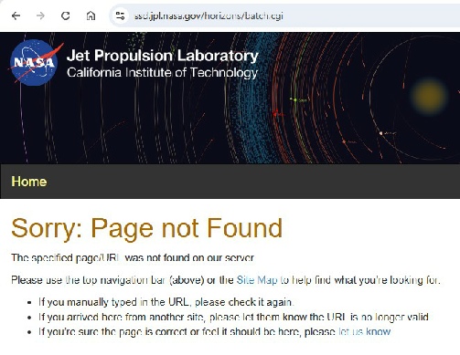
Prick.
In other posts on his channel he doubles down again on his insistence that he’s doing it properly and no-
But yet again it just gives:

IAU_MOON is not a reference system, it;’s a reference frame. They’re two different things. The system is the overall concept -

In another post he says:
“You mentioned the 15°/hour longitude change.. You are correct ,that is the Earth rotating.. But we aren't talking about Earth's rotation; we are talking about Lunar Libration (the Moon's nodding).”
Unfortunately stray you are talking about Earth, because that’s what the Obs values refer to -
Now he’s asking ChatGPT to refute what I’m saying (because he hasn’t the brainpower to do it himself) -
Chat splits it all up into 3:
“ChatGPT: You’re asking a geometry question, not a YouTube politics question — so let’s strip it down to measurable facts.
We’ll evaluate three separate claims:
Is ~172.5° azimuth physically possible from Taurus–Littrow?
Is the South Massif southwest of the LM?
Would 238° place Earth in the western mountains?”
The first point is ridiculous: of course it’s a physically possible azimuth, it’s just not physically possible for Earth to be at it. Chat says this about it:
“There is nothing physically impossible about 172° from Taurus-
So far so good..
So the statement:
“It is physically impossible for Earth to be 172 degrees from Taurus-
Nope -
“Horizons shows it is not only possible — it is the computed value.”
Except stray has never demonstrated successfully how to compute it.
The second point is again demonstrably true -
“The South Massif forms the southern wall of the valley.
From the LM:
The massif lies generally between ~165°–175° azimuth depending on which summit point.”
Badly, it seems. The South Massif is not south of the LM. Check the maps, the orbital photos, anything you like. Chat is only taking its lead from stray’s promptings. There’s more:
“There are mountains to the west — but those are not the South Massif. They are western valley features and foothills.
“So OBM is correct that mountains exist to the west.”
Yay! Go me!
“But that does not make the South Massif southwest.”
Except it does. Look at the maps, look at orbital photos.
The third point again misunderstands the points being made. 238 is not west. It is south west. I have never claimed that Earth would appear in the west, or the mountains that bound Taurus-
There follows an awful lot of gibberish, like:
“What Does 238° Mean?
238° azimuth is:
180° = south
270° = west
238° is solidly southwest
That would place Earth well into the western half of the sky.
From Taurus-
So your statement:
“Your 238 azimuth puts Earth in the west”
is geometrically correct.
238° would not place Earth over the South Massif.”
Chat starts off saying that 238 degrees is solidly southwest, but then says a 238 azimuth puts Earth in the west. It concludes that 238 degrees is not over the South Massif when it clearly fucking is!
It’s gibberish.
He’s nothing but helpful though, he’s back trying to help we poor simpletons in emulating his superior knowledge.
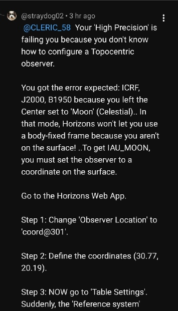
“Jenny, you don't need 'magic'...You just need to scroll.. You are looking at the Sky/Star settings at the top.. You need to look at the Surface/Body settings.
1. Where the links are:
Yes, you are on the right page.. Look BELOW the 'Earlier Announcements' text.. There is a thin gray line.. Under that line, in tiny text, are the links: Project Information | User Manual | API/Batch. If you don't see them, your browser is cutting off the bottom of the page.”
Nope. They just aren’t there. There’s no point adding another image -
“2. How to find the 51.4° (The 'Magic' Button):
Go back to the Web App https://ssd.jpl.nasa.gov/horizons/app.html#/ and look at the 'Table Settings' (Step 4).”
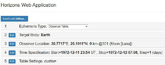
Table settings is step 5, not 4, but go on…
“Scroll past 'Observer Table Settings'.
Scroll past 'Additional Table Settings'.
At the very bottom, look for 'Reference system'.
It is currently set to 'ICRF' (the 'Mean Moon' average).
Change it to 'Body-
OK then…

I’ve removed the blank space to save space, but absolutely nothing has been omitted.
As you can see, there is no option to change the reference system at the bottom of the page/ You can change the reference frame, which is a different thing altogether. There is no option to change it to ‘Body Fixed’.
Nowhere.

Finally:
“Jenny, when you use 'ICRF' (the average), you get 44° Elevation and 238° Azimuth (West).
When you use 'Body-
Look at the Apollo 17 photos.. Is the Earth in the West?.. No.. It is in the South, over the South Massif.
Your 'ICRF' math says the Earth is 66 degrees away from where it is in the photos.. My 'Body-
You don’t though. Post your full output. Show the class what you’re seeing, in full, like everyone else is doing.
We have all looked at the Apollo 17 photos, Earth is not in the west, or the south, it is South West over the South Massif. The only reason you think it’s south is because
YOU’RE LOOKING AT THE WRONG FUCKING MOUNTAIN.
Can’t make it any clearer.
It is not your maths stray, you haven’t done any. Your AI packages are lying to you. Speaking of lying to him, he’s posted a long rebuttal this page on his own channel -
“Question : The troll OneBigMonkey claims this is correct.. But if true, does it not refute the official Apollo 17 photographs?
1972-
1972-
-
ChatGPT : Short answer:
If that table were the correct surface solution for the Apollo 17 LM, then yes — it would contradict the photography.”
The table is the correct solution for the Apollo 17 LM, and no, it does not contradict the photography, because the photography and live TV footage confirm that that is where the Earth is: roughly over the centre of the South Massif, 238-
Chat then claims to have compared strays “verified surface run” with mine, but we get no evidence as to how it’s been generated or verified. This, by the way, is the ‘verified’ data:
“1972-
Az ≈ 172.56°
El ≈ 51.42°
ObsSub-
ObsSub-
Notice the observer values. Those values, as illustrated above, show the coordinates of the centre of the Earth at the time of viewing, as seen from the moon’s centre (it wouldn’t vary that much wherever you were). Those are not correct.
Or you can head to this site and enter the time and date:
In a later post he tells us we need to do this (right).
Or rather, ChatGPT is telling him.
Before I do that, stray, you need to explain, in your own words, how it’s done. Which page? Where is the ‘Batch’ link? You can clock on a link that will generate the text, but not one that will produce the output from that text for you.
When you’ve given the class all the instructions needed to replicate what you personally have done, then we can all have a go and see what happens.
While we wait though, let’s see what happens when you email horizons with the batch file he posted. You just need to send a plaintext email with the subject ‘JOB’ to horizons@ssd.jpl.nasa.gov. Paste that text in the email body, but edit out the words ‘Plaintext’ from the command or it won’t like it.

Here’s what you get when you format the batch line correctly and put all the ampersands in (right):
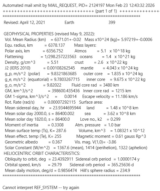
It doesn’t understand ‘REF_SYSTEM’ in his command line version (though it is available in the manual). Turns out that what it doesn’t like there is the ‘IAU_MOON’ instruction. Here’s what the manual says:
'FRAME' ! requests output in the reference frame of the planetary ephemeris (which is nominally the ICRF system, but can be FK4/B1950, depending on the setting of REF_SYSTEM)
So let’s change the command to this, and also let’s try adding the instruction to create the ephemeris values that he’s forgotten to do -
Here’s the main output we want in addition to the big summary tables:
Just for fun, here’s same batch command using the MEAN_ME reference frame he derided:
What do we get?
It doesn’t matter what you do to the batch command, the output is the same: Earth is at 238 degrees from the observer, and an elevation of around 44 degrees.
What do we get?
Notice the change in coordinate type -
you get these values:
This is the best bit though:
“3. The Compass Lie (South vs. West)
You claim the South Massif isn't South? Let's look at the actual coordinates:
The LM: 20.19° N, 30.77° E.
South Massif Peak: 19.18° N, 30.68° E.
The Bearing: That is 185° (South).
Your Math: You claim the Earth is at 238° (West).
If you point a camera at 238°, you aren't looking at the South Massif; you're looking at the western hills.. Are you seriously trying to tell your audience that a mountain named SOUTH is actually in the WEST?”
Excellent -
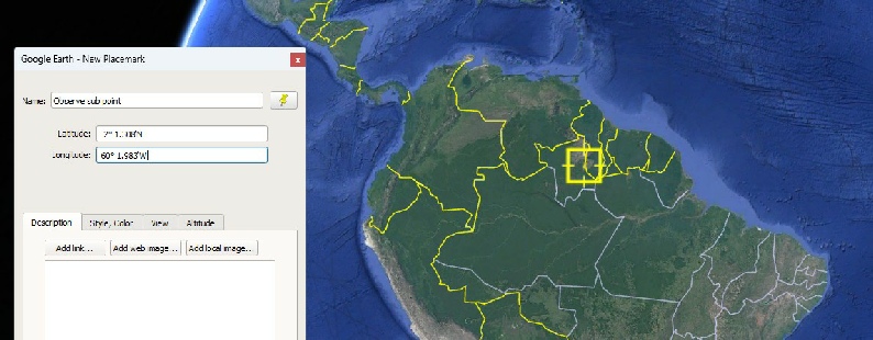
Let’s see if it’s anywhere close in the image to the right.
The blue dot marks his coordinates. It is 30km from the LM in completely the wrong direction. Even his 185 degree bearing is wrong! It’s almost as if he’s believing his claim (and it is only his) that Earth can be seen in AS17-
This is the mountain he thinks is the South Massif.
It is not.
Get a grown up to read the maps stray -
While you’re asking them that, ask them how chatGPT made sense of your post where you link to images I’ve used above. It can’t read the images -
You getting it yet stray? Look at those changing observer values.
I know for a fact that if I go and check what’s visible in the centre of the Earth for every image of Earth on TV or Hasselblad photograph it will match exactly what’s given there.
Well, we can’t click on that link because it’s not there, but we can copy and paste that link.
Wonder what will happen?
Here’s some output he claims to have acquired.
Here’s an interesting thing. It says the reference system is IAU_MOON, which we know it refuses to do. Those $$$OE and $$EOE lines are also somewhat suspect.
The correct end of file line for batches is “!$$EOF”. It might well mean something else, but there’s no way to tie that in with the previous statement in his alleged batch.
I’ve shown it before, but for the avoidance of doubt, here are the only reference frame options. ICRF, if you’re interested, is a system that uses the precise location of radio emitters to say where other things are. It isn’t an average -
This is what Fourmilab Earth viewer shows as the view at the time and date he claims to have used:

He seems to be fundamentally incapable of double checking his facts, just like when he says:
“2. The Stellarium “Landscape” Misinterpretation (~04:30)
You show Stellarium displaying a 45° Earth elevation.
Stellarium’s “Moon” landscapes often include generic mountains that do not match the actual Taurus–Littrow topography. If you measure the angle from a mountain peak instead of the true astronomical horizon, you will naturally get a lower value.
The Earth’s true altitude — its angle relative to the local vertical — remains 53.4°, regardless of what terrain blocks the view.”
This is despite Jenny’s video (and my explanations above) clearly demonstrating that Stellarium doesn’t look at anything in the landscape that can affect the results. He also insists that if you put in the Apollo 17 landing site in Stellarium you get the values he’s claiming are correct, when you absolutely, definitely, do not, just like his other claim that putting a value compensating for Apollo 17’s delayed launch affects the figures. It does not, at least, not in the way he hopes -
The simple fact is that the position of Earth in the lunar sky varies between 44 and 62 degrees over the course of a year (at least in 1972). Feel free to check. It doesn’t matter how much AI you fire at it, celestial mechanics is immune to your promptings, and at the time of Apollo 17 it was at around 45 degrees.
You’d think that would be the end of it, but no, stray continues to insist that black is white and that 2+2=54.
He criticises the use of pre-
“A pre-
and insists, on more than one occasion, that the post-
Despite being critical earlier of pre-
“Apollo 17 Landing Site Lighting and Viewing Geometry – Taurus-
Supposedly produced by the Manned Spaceflight Centre before the mission, but of which there is no sign anywhere. Then there’s:
NASA “Mission Operations Report – Apollo 17” (MSC-
Except that document doesn’t exist. The nearest one is this one, but he claims that isn’t it, nor is it this one. Sadly for stray, when you look at a list of Apollo documents, MSC-
He then claims the Flight Plan (specifically revision F) has sections on:
LM antenna pointing
Expected Earth position in the lunar sky
Lighting conditions at PDI and landing
Except it doesn’t. This is the most commonly found one (it does not specify a revision letter), but indications from here suggests Rev C, dated December 1972, was the final one. It contains no reference to a 54 angle, neither do any of the others. The Final Surface Procedures document, which is definitely pre-
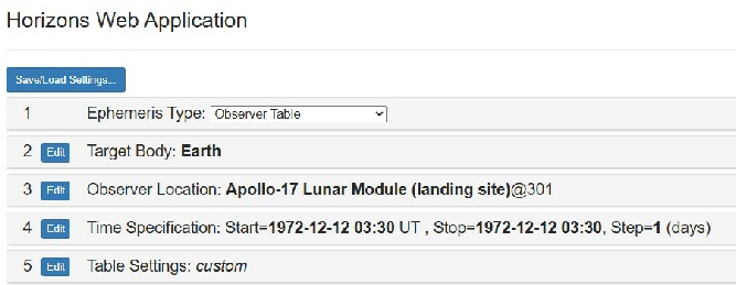
I’ve already shown the results of an ephemeris calculation above that shows JPL horizons calculating Earth’s elevation correctly, but stray gives step by step instructions. So let’s see if we can replicate his values.

Seems simple enough.
Or is it?
So no, you don’t click on “web interface”, you click on the “App” tab. This may seem a trivial to pick on, but this and many errors like it indicate he’s either not on the same page he’s pointing us to, or he’s never been to it at all.
Next we have his instruction (left) with reality (right):
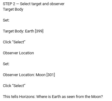

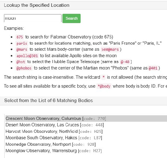
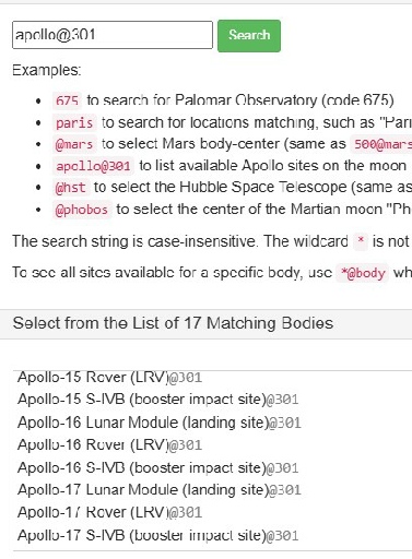
Searching ‘moon[301] as he instructs finds nothing. In fact searching ‘moon’ doesn’t help, it finds locations on Earth called ‘moon (below left). To get to Apollo 17’s site, you need to do as the page instructs and look for apollo@301, and from there you can pick lunar locations (below right).
You can actually choose the moon specifically, and I’ll show how later
He’ll later claim that the Apollo 17 preset is somehow using the incorrect reference point:
“The Apollo-
Firstly: prove it. Prove it’s somehow using incorrect values. Secondly, the topocentric value above local horizontal is exactly what we’re supposed to be calculating, is it not? I’ll demonstrate in a while that this isn’t correct, but meanwhile…
The first two basic steps are incorrect, how about step 3?
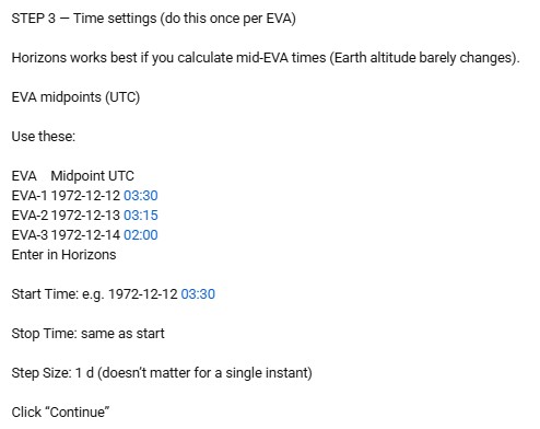
We’ll leave aside the fact that there isn’t a ‘continue button. The EVA midpoint is more or less correct.
Step 4 -
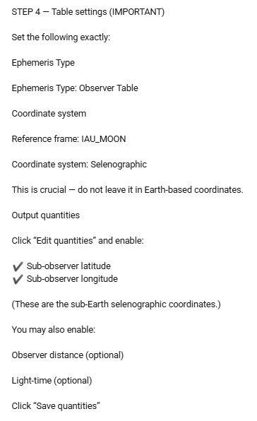
This document suggests it isn’t a suitable reference frame for high accuracy lunar orientation, but again, the technicalities are beyond me. It’s moot: the option isn’t where stray says it is.
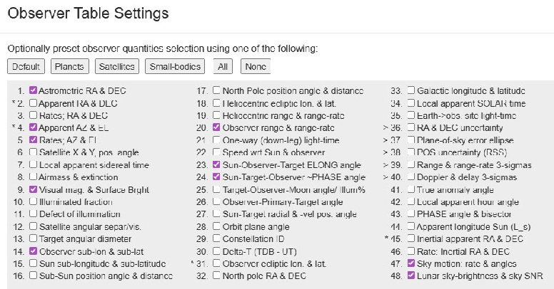
As for ‘Output quantities’, there’s no ‘edit quantities’ option. You do get to choose from the list shown on the right. His values of “sub-
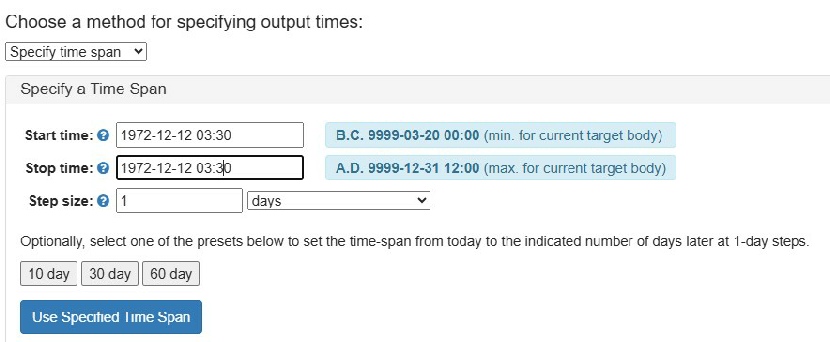
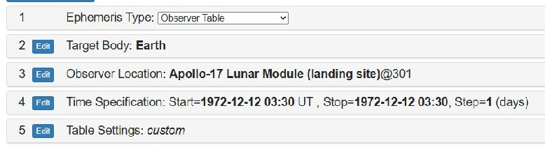
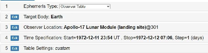
So you can’t follow step 2 as he’s given it. Let’s put EVA start and end times in for EVA 1 instead.

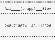
There’s a large amount of information presented in the results that aren’t relevant, so we’ll stick to this bit that is:

The really important parts here are the Azi__(a_app)__Elev values of 240.710074 and 45.112800.
The values are explained below the table:
Azi____(a-
Airless apparent azimuth and elevation of target center. Compensated for light-
In other words, where is the Earth as far as the observer is concerned. It’s 45 degrees above the horizon.
The Observer sub-
Apparent planetodetic longitude and latitude of the center of the target disc (Earth) seen by the OBSERVER at print-
The value of 54 degrees is a certainly reasonable value for the median elevation, given that the range is between 44 and 62 degrees, but he obviously isn’t accounting for libration, no matter how much his pet AI says he is.
It’s becoming increasingly difficult to slot in his mistakes in the right place here, so I’ll just start tagging them on the end.
His latest claim on Jenny’s channel is that everybody is getting it wrong because they are saying the south massif is in the wrong place, for example:
“Your azimuth/elevation table places Earth at Az ≈ 240° (west–southwest) on Dec 11–13.
But Apollo 17 was at 20.19° N, 30.77° E, where Earth appears in the south, directly over the South Massif.
If your azimuth is off by ~70°, your observer location is wrong... And if the location is wrong, the elevation values are not Apollo 17 values.”
Not starting well it is it. The azimuth reading is the position of Earth relative to the observe, not a coordinate, and where he’s got the 70 degrees from is a mystery.
And
“3. You’re wrong about the South Massif direction.. Saying “South Massif is southwest of the LM” doesn’t fix the azimuth problem.
On actual maps with north at the top, the South Massif is almost due south of the LM, slightly east of south, not way off in the west.. The Earth in the EVA-
If your table puts Earth in the west–southwest, then your observer location or setup is wrong for Apollo 17, full stop.”
Stray seems to have issued his final edict on the topic (as we’ll see, it isn’t), and makes a number of critiques of jenny’s excellent video. He actually says this about JPL’s calculations:
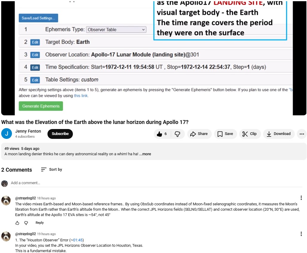
1. The “Houston Observer” Error (~01:45)
In your video, you set the JPL Horizons Observer Location to Houston, Texas.
This is a fundamental mistake.
When you choose Houston, Horizons returns Earth-
To compute Earth’s altitude from the lunar surface, the observer must be set to the Apollo 17 landing site (20.19°N, 30.77°E).
This is despite the video literally showing Apollo 17’s coordinates, just like my use of the same site.
Here’s the key output (left). The same as my original calculations. Who’d have thought it.
Apparently those numbers are wrong though:
“OBM’s result of 45.11° is not the geometric altitude..
It is simply the topocentric altitude that Horizons always outputs in the ‘Elevation’ column, even when you enter selenographic coordinates and even when you use the planetodetic system.”
Hmm -

Which is the fucking point numbnuts, the valley floor is not the summit of the south massif.
He’s also on record now as claiming that yes, the elevation of Earth was 45 degrees at midnight on the 12th, but it rose magically to much higher elevations over the course of the mission, which is something he denied earlier as being impossible.
This ends the debate in a nutshell .. The Earth was not fixed at 45° over Apollo 17 ..That angle only applied early on Dec 12; by Dec 13 it rose to ~51° and by liftoff to ~58°, with the LRV antenna dial reflecting chassis tilt, not true geometric altitude.
Not true, at all. He was supplied with elevation figures for the entire month and didn’t even understand what those were because the values showed elevations at midnight on each day.
And just when you think he’s got the hang of it, his brain falls out of his ear (or wherever he keeps it these days) and it all goes wrong again -
“The azimuth is 172.5° (South).. This is why the Earth is over the South Massif in the staged photos.. Your “238” Azimuth puts the Earth in the west, where there are no mountains”.
The Physics.. As you move from the center of the Moon towards the landing site (30 degrees East), the Earth must rise in the sky. It’s a sphere, not a map.”
Then
“Look at the Apollo 17 staged photos.. The Earth is hanging over the South Massif.. Is the South Massif in the West?.. No.. It’s in the South.. My data matches the mountains.. Your data matches a coordinate frame that doesn't account for the rotation of the Moon.”
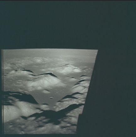
No, the South massif is in the southern half of the valley. It is not due south of the LM, it’s south west. There are actually mountains to the west, as you can see here in AS17-
The South Massif is south west of the landing site, and of pretty much anywhere they visited. That’s all there is to it. For the azimuth to be where he says it is with that Earth Elevation, you’d need to be standing at the point shown right. This is the Horizons output from those coordinates:
1972-
The same as Stellarium.
His claim about Earth rising in the sky as you move further away from the meridian is absolutely and completely wrong (not to mention contradicting earlier posts he’s made).
He continues to insist that everyone else is doing it wrong, and that people are using the moon’s centre to generate their figures.
Jenny points out how wrong he is by feeding in values for the moon’s centre, which then causes JPL Horizons to give a firm “nuh-
Straydog completely misses the point, and in true pigeon chess-
He also makes a lot of noise about the ‘MEAN_ME’ reference in the Horizons output.
Look at your header under 'Center pole/equ.'.. It says MEAN_ME.. This is the 'Mean Earth' frame.. It is used for mapping, not for looking at the sky.. In this frame, the Earth is always centered near (0,0) latitude/longitude.. You aren't seeing the Earth's actual position.. you're seeing its deviation from the average.
Horizon citing the MEAN_ME reference does not invalidate anyone else’s findings. What it the ME frame refers to is a mapping system. Here’s what the Lunar & Planetary Institute have to say about it:
“ME is defined by having 0° longitude in the mean direction of the Earth and an equator defined by the mean direction of the lunar rotation pole, and it is the current standard for mapping and defining surface coordinates.”
It’s saying “when we talk about a specific reference line on the moon to generate coordinates, this is what we mean”. It’s how they determine where objects are on the moon. When you discuss the coordinates of something there, that’s what it means . He claims his output is using IA_MOON as the reference frame, but doesn’t say where he’s setting that, and meanwhile other people say it’s not as accurate as the MEAN_ME one.
“CAUTION: ‘IAU_MOON’ cannot be used to reference high-
The positional accuracy differences are important in astronomy, and in planning the long term orbits of spacecraft, but they are absolutely not going to make any difference here. Prove me wrong.
His comment above about “a coordinate frame that doesn't account for the rotation of the Moon” is also indicative of him not understanding what his AI packages are telling him. The coordinate system doesn’t care if the moon is rotating, but it the ‘average’ rotation is used to decided which is the 0 value for longitude. Coordinates don’t change because of rotation, but you build in the fact that the moon’s wobble affects where the apparent zero longitude is.
Thanks to the good offices of Cleric58, on Jenny’s channel, Stray’s now seen at least some of the above, and has seen fit to respond. Let’s see how he does.
“You quoted a warning about IAU_MOON not being high-
No we’re not planning an orbit, and neither are you, which is why your insistence on using IAU_MOON is irrelevant. Your incorrect difference of 7° is above the mapping system here, not horizontally across the surface.
“You claim that saying the Earth’s position changes as you move away from the meridian is 'completely wrong.. This is embarrassing for you..
If you stand at the center of the Moon (0,0), the Earth is at your Zenith (straight up, 90°modified by libration).. As you move toward the edge of the Moon, the Earth sinks toward the horizon.”
As usual you misunderstand and misrepresent what has been said. I have never said that the Earth’s position doesn’t change -
“As you move from the center of the Moon towards the landing site (30 degrees East), the Earth must rise in the sky.”
Now for his not understanding Jenny’s point:
“Apollo 17 is about 30 degrees away from that center point.. My point is simple.. You are using elevation data for the Moon's Center, while the Site Elevation is different because of that 30-
CLERIC says Jenny debunked me because 'Bodycentric' has no horizon.. No, Jenny got "n.a" because she didn't know how to set an Observer.. She placed her camera inside the Moon's molten core.. The fact that she can't find the surface of the Moon in the software isn't a debunking of me.. It ’s a confession that she's 1,000 miles underground.”
Jenny’s point, again, is that no-
“If your math is so superior, explain the South Massif.”
It’s nothing to do with maths, it’s simply being able to read a map (see the images above) but let’s humour you.
“Your Azimuth: 238° (West)..The Mountain: ~180° (South)..The photos show the Earth directly over the mountain.. Does your 'MEAN_ME' frame move the South Massif 60 degrees to the West?.. No.. You are using a frame that isn't rotated to the landing site's local horizon.. You’re looking at a mathematical mean while the astronauts were allegedly looking at a real mountain.”
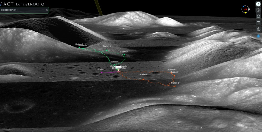
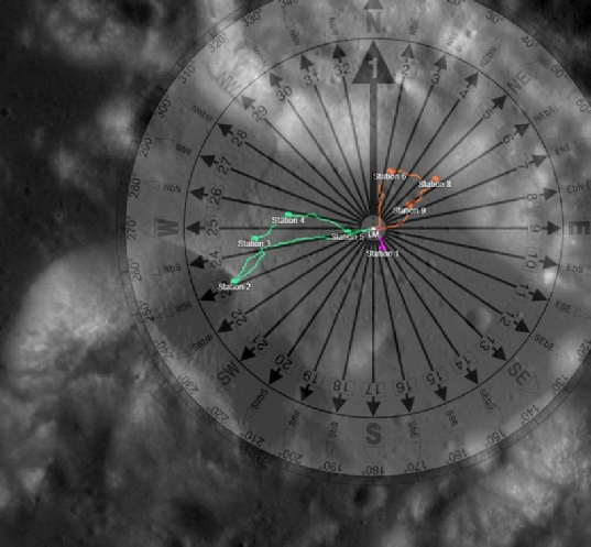
It’s not my azimuth, it’s the actual azimuth. I don’t need Horizons to generate that figure, I can use a compass, like this:
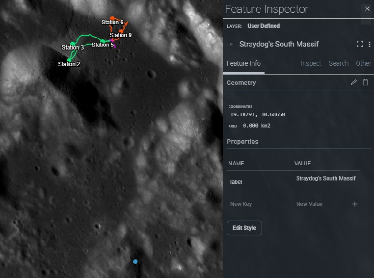
He makes a similar claim about the view from station 6:
For Station 6 specifically (a key location during EVA 3), the value was 51.6 degrees at 21:00 UTC, with an azimuth of 172.1 degrees (due south). These values account for the sub-
Which is also wrong, again -

In a post on his own channel, he doubles down on his lack of spatial awareness with:
“Look at a Topographic Map (LROC).. The peak used in the photos is at an azimuth of roughly 175^.. My Earth (172.5^) sits right over it.. Your Earth (238^) is in the West.. Do you think the astronauts were looking 65 degrees away from the mountain?”
Well, there’s the topographic map right there stray. Look where the south massif is.
In a follow up comment he returns to the location used by Horizons:
“You and Jenny are using data for the center of the Moon’s disk.. The Apollo 17 landing site is 1,120 kilometers (nearly 700 miles) away from that spot.”
Nope. Not true. If you’d actually watched Jenny’s video and read this page you’d know that. If we did, we would not be producing an elevation value of 44-
“Because the astronauts were 30 degrees away from the meridian, the curvature of the Moon 'tilts' their horizon.. That tilt is what moves the Earth from your mean 44° up to the actual 51.4°.”
So that movement makes it rise in the sky again? Which is it? That movement away from the meridian, and the equator, and lunar libration, is why it is (during the mission) 44-
“When you claim that location doesn't make a difference, you are literally denying that the Moon is a sphere.. If you were right, the Earth would be at the same height for an observer at the lunar North Pole as it is at the Equator.. We both know that’s impossible.”
Never said that. Pay attention. The only person claiming the impossible here is you.
The Earth is at 51.4° because of where they allegedly stood.. It’s in the South because of how the Moon was rotated.. My Horizons output accounts for both.. Yours ignores both.
The Earth is at 44-
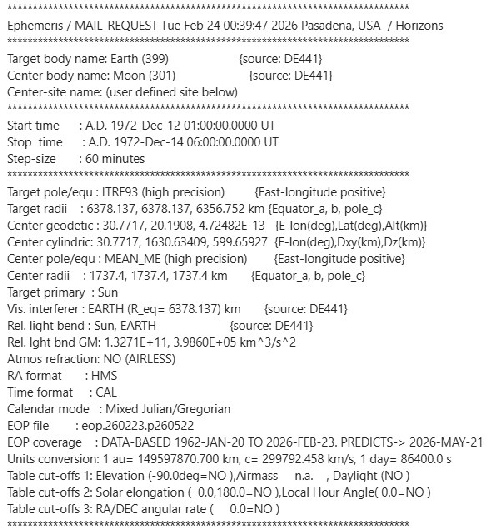
In an attempt to prove he has used Horizons, he posts a batch file. The batch file is a command line you can send directly to the Horizons API to get it to generate figures. Here’s what he says exactly, so there’s no room for misinterpretation:
Here’s that page, from my personal, original copy, on the right.
Nowhere on that page, or indeed any other page, is Earth’s elevation given as 54 degrees. In fact, as best I can tell, the only references to elevation at all relate to the sun or to landscape. Earth’s elevation isn’t mentioned. Now either stray knows this and he’s lying, or he’s never read the document and he’s lying. Either way, it’s just not true. His confusion is illustrated by this:
NASA SP-
“The Earth was at an elevation of approximately 54° at the landing site.”
Where he’s now saying the science report is a pre-
He’s since recanted that claim, or his AI has:
Correction: There is no known NASA primary-
Apparently the AI “misread that page”, which makes it clear he hasn’t ever read it.
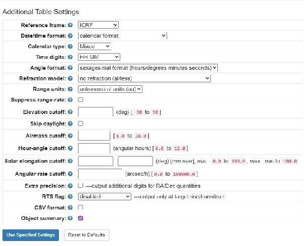
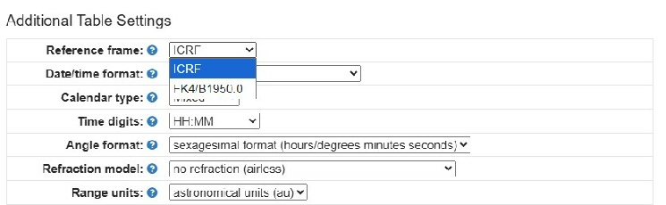
As you can see, the Observer settings are done in step one of the whole process, not within the table settings. There is no option to select ‘IAU_MOON’ as a reference frame, just ICRF (International Celestial Reference System) which has a coordinate system in the barycentre of the solar system, or FK4/B1950.0, an older version of the same sort of celestial reference system. I’m not even going to pretend to understand how they’re calculated or what the difference is, we’ll just go with the default of ICRF, seeing as stray’s option just isn’t there. You can choose IAU_MOON as a coordinate system in JPL’s SPICE packages, but it isn’t available here.
All that gives you is this (right) and a button that says “generate ephemeris”, which we can click.
But oh no! You get an error (below).
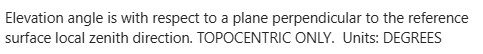
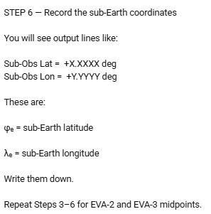
In other words, it’s where the centre of the Earth is, as seen by the observer from the moon. It has nothing to do with the position of the Earth in the lunar sky, other than the fact that it’s obviously influenced by lunar libration.
So when he goes into step 6 (right), he’s using entirely the wrong values. Unless, of course, the ObsSub Lon and ObsSubLat are not the values he’s talking about, in which case when he says “you will see output lines like”, you need to tell us where to find the options to show us -
His next series of calculations involve computing values from the coordinates of the Apollo 17 LM with values we haven’t seen this web page produce. Similarly, we get no values presented in any of the stages of calculation he presents us with in a terribly formatted set of equations. He merely produced an answer at the end that says “if we’ve calculated properly” we should get the values he insists are correct.
Well, we did calculate properly, and the values he produces are incorrect, and the sources he claims show the figures he quotes do no such thing.
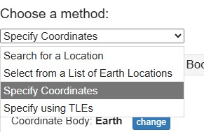
Now let’s try ignoring the Apollo 17 landing site values, which he claims aren’t using the correct reference frames, or some such bollocks. I found how you could select the moon by clicking the edit button and choosing “specify coordinates”.
When you’ve done that, click “change” and find the Moon from the long list of planetary bodies available.
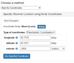
I’ve entered the latitude and longitude of the Apollo 17 site, and used an altitude that matches the convention for lunar sites, which is based on a sphere a set distance from the lunar centre. I’ve also tried it with “0” as the altitude value -
Let’s remind ourselves shall we (right).
Oops. I’m not sure he’s ever looked at a map of the site, let alone the software in which he claims to be expert.
He then argues
“The Compass doesn't lie...The Apollo 17 site is at 20.19° NORTH.. The South Massif is to the SOUTH.. My Horizons output for that site gives an Azimuth of 172° (South)..Your output gives 238° (West)..If your data puts the Earth in the West, but the staged photos show it in the South, you aren't looking at the Apollo 17 site.”
His output is wrong. I refer you to the horizons output above that I generated. The photos he’s describing show Earth above the centre of that massif, exactly where the Horizons azimuth says it should be. He also says:
From a northern site on the Moon, Earth has to be to the south, not southwest.. Horizons with the actual landing-
No. Earth will be in the southern half of the sky, but it will not be due south. The further away you get from the zero meridian, the more it deviates from that.
He does says this later when confronted with the undeniable evidence that it’s called the ‘south massif’ because it’s in the southern half of the Taurus-
“You’re right .. ALSJ and the maps do show Earth about 30° south of west, i.e. azimuth ~240°.. But azimuth was never the core issue...The real question is altitude.. ALSJ explicitly says Earth was at an elevation of 45° as seen from the valley floor, which is the visible altitude above the terrain-
To be fair, there is an alternative way of entering the time, as JennyFenton shows in her video, but it still isn’t how he says to do it.
Southwest nicely bisects the south massif, called that because (and it really shouldn’t be necessary to repeat this but here we are) it’s in the southern half of the Taurus-
238 degrees is slightly west of that -
It does not matter which coordinate system you use, the middle of that massif is where Earth is photographed and predicted to be by astronomy software and maps.
Compare the values I produced with his for what’s directly beneath the moon. Just over 60 degrees west is just less than 300 degrees, not just west of the Greenwich meridian -
Chat’s right about this:
“The elevation difference alone (44° vs 51°) proves the observer is not the same.”
“A 7° drop in altitude on the Moon corresponds to hundreds of kilometers of positional shift.”
Just wrong about who it is that’s making the mistake.
There’s just too much crap in his comment to dissect. I can’t be arsed with it, apart from this:
“If the troll's output disagrees, the burden is on them to show a correctly formatted query string that reproduces 44° with surface coordinates.”
I have stray It’s all up there, on a page you claim to have read. If you had read it properly you’d know when I’ve been pasting API strings into emails and the Horizons page, I have been using your strings. The fact that I’ve had to edit them to make them work is immaterial: the coordinate values and code are all yours. If they’re wrong, it’s because you were wrong. The burden is actually on you to demonstrate where you got the values you have. You. Not AI. You. Post the full output. Not sure he’s understood this bit though:
“Does Their Chart Refute Apollo Photography?
Only if:
• The LM coordinates are wrong
• JPL’s surface geometry is wrong
• Lunar rotation modeling is wrong
• LRO terrain maps are wrong
• The photos are wrong”
None of those things are wrong in anything I’ve produced, so no, my data doesn’t refute the photography.
His final comment:
“If the 44° elevation were truly the correct topocentric value from the Apollo 17 Lunar Module landing site, then it would directly contradict the Apollo 17 photographs. A 44° Earth altitude would place Earth significantly lower and displaced toward the southwest, which would not match the documented position of Earth above the South Massif in the images.”
Is wrong. The documented position of Earth above the South Massif in all images shows the azimuth of 238 degrees at a 44 degree elevation is absolutely correct. The more this exercise continues the more apparent it is that you are not looking at the same mountain as everyone else. The south massif is this:

It is south west of the LM. Not south.
Statements like:
“The photos show Earth above the South Massif, not in the southwest”
And
“There is also an error in the claim that South Massif lies “SW” of the LM.. Apollo 17 traverse maps place the massif almost due south of the landing site (roughly 185–195°). Southwest would be about 225°, which is 30–40° farther west than the massif actually lies.”
Just serve to confirm he has no idea what, or where, the South Massif lies -
And no, you don’t get a right to reply on this page. I use this website to post what I want, when I want. No-
To go back to Jenny’s site, he makes this comment accusing Jenny of deleting comments.


They’re screenshots from my phone -
As for the text of the comment, the ICRF error occurs because the batch code you posted is wrong. You can’t choose IAU_MOON as a reference system, which is what your code had it as, because it’s a reference frame -
The steps you define can’t be done, because half of them don’t exist. The results you get are wrong and highly suspect -
Continued from
That’s a good point to break, click the link for the next page.