2.4 Other Satellites
A number of additional sources of satellite images can be found in largely isolated examples across the internet. ITOS, or 'Improved TIROS Operational System', was an advancement on the previous ESSA satellites. A series of these new generation TIROS satellites were launched from 1970 onwards, and had various names attached to them as new administrative bodies were formed. The aim was to double the observing power of the satellites in operation by adding more satellites to existing polar orbital patterns.
ITOS-1 was launched in January 1970 and carried 4 improved versions of the camera technology employed by its predecessors capable of both visible and infra-red spectrum data. The satellite was deactivated in June 1971 after technical problems halted some of the on-board experiments in the preceding November, and caused problems with attitude control systems in March 1971. More information can be found here, here, and here.
The next launches in the ITOS series were christened NOAA, after the National Oceanic and Atmospheric Administration responsible for them. NOAA-1 (NOAA) was relatively short lived, launching in December 1970 but shutting down in June the following year. The only data catalogue found does not cover any of the Apollo missions.
The next satellite in the ITOS series was NOAA-2, and for the first time a satellite did not rely on TV imaging for its cloud cover data. NOAA-2 used radiometric imaging, using a combination of thermal and visible radiation measurement to produce an image of the cloud patterns below it. Despite this advancement in measurement technique, the data were still recorded on magnetic tape and transmitted on demand. More information on NOAA-2 can be found here, and links to the scanning equipment here.
There do not appear to be any comprehensive data catalogues for NOAA-2, but occasional examples do show up in journals and other reports.
Perhaps the most interesting satellites available are those specifically operated by the military. The US armed forces were quick to realise the possibilities of using satellites and rocketry to observe their communist enemies - especially as their spy planes became more well known. While early efforts used straightforward 'up and down' rockets, eg those in the 'Corona' and the subsequent KH7 and KH8 GAMBIT programmes to pass cameras over the target territory and return to Earth with films for processing (there was little point in transmitting sensitive images to Earth as they could easily have been intercepted). Interestingly, the secretly developed emulsion used in the film for CORONA images was declassified so that it could be used by NASA for Apollo photography.
It soon became apparent, however, that predicting weather in Vietnam (and the USSR) would be useful, for a number of reasons. Primarily, it made sense, if you were sending a spy plane or a camera up into communist air space, to know whether or not it was cloudy there, and it also made sense to not have to ask someone if the weather over, ooh let's say Hanoi, would be cloudy tomorrow at about 09:00 just in case anyone happened to be flying overhead. It also helped to plan attacks or troop movements in those conflict arenas that were active in SE Asia, and to determine where Corona satellites should be targeted and recovered - Corona and GAMBIT were useless in cloudy weather. One report estimated that the military programme of satellite deployment paid for itself many times over by preventing unnecessary airborne reconnaissance missions and unsighted bombing runs.
At the more extreme end of usefulness, information on likely dispersal patterns for radionucleides, and the availability of long range targets was also likely to be useful. The Cold War is often dismissed as irrelevant in the world of the conspirator, and this is usually a good indicator that they didn't live through the nervy nuclear tensions that were a part of everyday life in the era before the fall of the Berlin wall.
In order to acquire this meteorological information without having to ask anyone, and according to some commentators in order to speed up development where civilian programmes didn't satisfy military needs, the military had a programme of launches of their own, for example the SAMOS satellite. It has been suggested that many of the innovations developed for this programme were later adopted in civilian designs, such as magnetic spin stabilisation. Another example is the cameras used in SAMOS, which went on to be used in the Lunar Orbiter series that mapped the Apollo landing sites (Source).
The program went under a variety of names, including the innocuous ‘Program 417’ (aimed at supporting the Corona program) and 'Data Acquisition and Processing Program' (DAPP), and then later on Defense System Applications Program (DSAP) and Defense Meteorological Satellites Program (DMSP). Some sources also argue that the DAPP programme was a result of frustration with the slow and overly bureaucratic process of satellite design and development within NASA. Examination of the literature suggests a co-dependence between the two, often sharing key personnel and transferring new developments between the two branches.
Another problem helping delay civilian satellites was the need to cram them with a large number of measuring devices - they had to be multi-purpose pieces of equipment, whereas the military satellites had a much narrower focus, and this specialism was what helped them develop better equipment more quickly. One area in which military satellites excelled was the development of night-time photography and targeting a camera view horizontally so that cloud heights could be determined more accurately. This article claims superior image processing and optics, and also claims double the resolution of civilian cameras thanks to being half the altitude, but its 450 mile altitude claimed is not half that of eg ESSA or NIMBUS! This document (which gives an excellent summary of the development of the military use of satellites) suggests that TIROS had a better resolution than DMSP.
That said, orbital trajectories and targeting of the cameras could be designed specifically with conflict arenas in mind, with pairs of satellites arranged to pass over their targets in the morning and evening. Of equal importance: the data could be encrypted instead of the open transmission types of their civilian counterparts.
While the early Corona images were not fully declassified until the 1990s, the DAPP/DMSP satellite data were declassified in March 1973, and images began cropping up in journals soon after. It is probably no coincidence that this declassification comes shortly after the end of the Vietnam war, which did make use of DAPP weather data. This publication describes the satellites and their operation in detail. Prior to declassification their data, and even their existence, were closely guarded secrets, with even different branches of the military denied access. The air force (to whom arguably they were of more use) jealously guarded their satellites from the other services, and very few personnel were given access to them. The army, meanwhile, continued to have to rely on field observations of notoriously changeable tropical weather in stressful and sometimes fatal battlefield conditions.
This early release means the satellite programme is well documented, but the full catalogues do not appear to be readily available online. The satellites themselves were similar in operation to their civilian counterparts, operating a sun-synchronous near polar orbit that took around 101 minutes to complete, at altitudes of around 450 nautical miles and above. The satellites had a series of developmental stages, and of particular interest to the Apollo missions are the Block 4 & 5 types with resolutions of up to 0.8 nautical miles. At least one Block 4 type was in orbit for Apollos 8-14, and least one Block 5 version was also in orbit for Apollo 12 onwards.
Meteorological data were recorded using thermal imaging and visible spectrum cameras, and they are widely reported as having better image resolutions than, for example, ESSA or NIMBUS, thanks to much better scanning equipment (giving a resolution of up to 0.3 nautical miles per scan line). Block 5 versions replaced vidicon cameras with radiometric systems in the same way that NOAA-1 evolved into NOAA-2. Whether this is true or not is a matter of debate - certainly the published records are comparable between the two. The difference is more likely to matter in the infra-red and horizontal imagery they needed for working on night-time bombing runs and reconnaissance.
The main receiving stations were restricted to a couple of bases, but the data could also be transmitted to field stations, as shown in figure 2.4.1.
This NOAA page gives brief details of one of the DAPP satellites, and this excellent history, Cargill Hall, describes the development of the satellites and the military programmes to which they contributed.
A couple of useful journals from ESSA and NOAA give more detail on how the processes worked, as well as give hints about the quality of the images. ESSA World January 1970 and ‘NOAA’ January 1972 ' have articles on the modern [sic] weather forecasting service and the role of the satellite in it. These two magazines have the look and tone of 'in-house' magazines intended for members of the services concerned, and possibly other government and educational agencies. There are adverts and so on for educational material that can be bought from them, so it looks as though they had a wider distribution.
The 'Space Command' article describes how a series of commands are sent to a satellite so that it will turn on a transmitter, transmit its data, and then turn the transmitter back off. It also helps explain the administrative structure. The ATS satellites, for example, are owned by NASA, but the data acquisition process is not carried out by them. Instead it is collected by a data acquisition station and relayed to an operations centre run by NOAA (this would have been managed by ESSA prior to NOAA's creation).
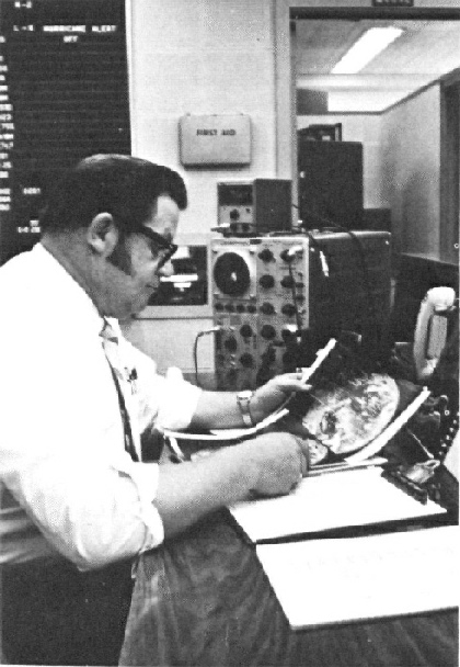
Figure 2.4.2 shows a member of 'Space Command' checking the quality of a satellite image.
Figure 2.4.2: Checking satellite image quality on receipt. Source: NOAA
The ESSA World article describes how the satellite images then end up with weather forecasters starting from about 06:00 local time. The strips and mosaics of photographs from the LEO satellites are “less than two hours old” by the time they get to the forecasters, although the ATS images are much newer. The interesting feature about the article is how many people are involved in the process of producing a weather forecast, and how satellite imagery was a relatively small part of that process.
Figure 2.4.3 shows someone from ESSA looking at a satellite image, and gives a good indication of the size of some of the printouts, and their quality.
Another ESSA world edition provides useful information about the role of meteorological forecasters within NASA. The article, published in April 1967 and available here, describes the work of the Spaceflight Meteorology Group (still in operation today: NOAA), which supported any NASA or DoD work involving orbital launches (and with missiles, sub-orbital), including the preparatory work of getting a launch vehicle to its launch platform. The link with DoD operations would prove useful during Apollo 11, as will be detailed in that section. One interesting observation in the article confirms that the crew do have up to date information with them, at least at launch:
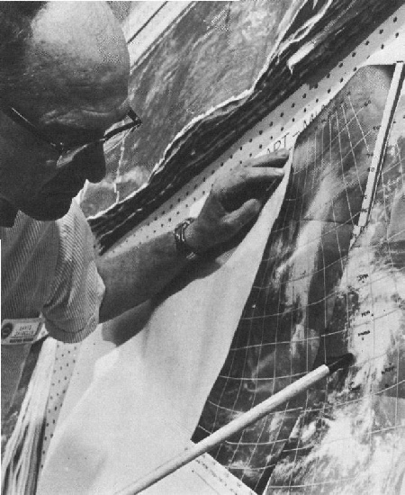
Figure 2.4.3: ESSA staff examine a satellite photograph as part of preparing a weather forecast. Source: ESSA World
"One specialised service just before each launch is the preparation of a weather map for the flight crew to take with them. On the map are shown the meteorological features over which the crew will pass, as well as areas expected to be unfavourable for landing and recovery operations"
This would obviously be more useful in the much shorter Mercury and Gemini missions than the longer Apollo ones. The article also describes the development of orbital photography as an important contribution to ground forecasting, helping to compare measurements taken by conventional forecasting equipment with visual observations. This was particularly true for the Gemini missions, but as will be shown in the section on orbital missions this work continued with Apollo. The article makes one forecast that did come true:
"One expectation for the future is that Weather Bureau men will help select a smooth landing site for the first astronauts returning from a successful voyage to the moon"
This obviously happened, and the involvement of these satellites in weather forecasting for Apollo splashdowns is proudly commemorated in these first day covers for Apollo 8 and 9 (figure 2.4.4).
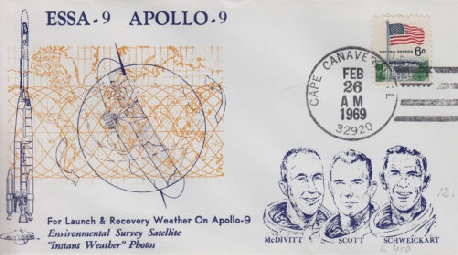
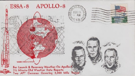
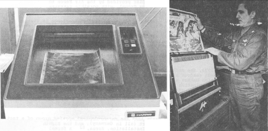
Figure 2.4.1: DMSP fax receivers in the field. Source.
Readers might also want to look at the two USAF seminars given to trainee meteorologists covering cloud types (part 1, part 2) and cyclonic weather patterns (part 1, part 2). The presentations make extensive use of civilian satellites, and give an insight into the contemporary understanding of how satellite data could be used in conjunction with other data. I cover these in more detail in the discussion section.
Figure 2.4.4: First day covers commemorating the role of ESSA satellites in the recovery programme for Apollo 8 and 9.
Summary
Satellites orbiting the Earth in the 1960s were engaged in data collection for meteorological agencies not just in the USA but worldwide. They operated slightly differently, but in essence they all used cameras that scanned the surface and recorded the image on magnetic tape. Data from these tapes were transmitted, either automatically or on demand), to ground stations using VHF signals. Receiver stations recorded these signals and converted them to TV images, which were photographed using kinescopes. The images could be sent over fax networks, and participating countries could record images directly.
It is also recorded that NASA used satellite imagery to work out forecasts for launch dates, and for the landing areas after re-entry. They also used them to help work out what the astronauts described from their view in space. Satellite imagery and other forecasts were supplied by ESSA, who also worked closely with other government agencies – including the DoD. Richard Underwood, one of the key personnel behind Apollo’s photographic procedures says in his oral history used in desk in the weather console, as it was only needed at launch and re-entry:
“So I had access to all that equipment and all the weather satellites. I could even tell where weather was all over the world. These were rather rudimentary satellites compared to today's satellites, but you had the general idea. No point in saying, "Hey, we want you to get a picture of a certain area" when you know it's cloudy. There's no point in them either orienting the spacecraft and using fuel or staying awake or even looking out the window. And also we knew where the storms were and fronts and other weather things to tell them, "Hey, you're going to come up on a hurricane three hours from now," or something. "Try to get a series of pictures."
So the ground had access to weather details and could direct attention of astronauts towards it, particularly for the Earth Orbit missions, but nothing like the detail recorded by the missions’ cameras.
The satellite images used in this research all originate from the USA, but other countries were also launching weather satellites, including the UK, China & the then USSR. At the time of writing, images from other space and meteorological agencies are unavailable. It is hoped at some point to incorporate these other sources as further corroboration of Apollo images, as the political situation at the time means that co-operation between the US & USSR in particular was unlikely. Soviet confirmation of US data would be particularly useful.
It has also become evident that many technical journals and academic libraries contain much more information than has been gathered here. The only thing preventing access to these sources is money and proximity. If anyone is well placed in either of those respects they are encouraged to take up the mantle and expand the record further.
A new addition to the site is the inclusion of modern digitally recovered images from the NIMBUS and ESSA programs. The next page describes those files and shows you how to process them yourself.
Back to Index
Nimbus Satellites
2.4 - Modern imagery