4.7.0 - Apollo 15 Introduction
Having re-established the Apollo missions with 14, Apollo 15 took them to new levels of scientific exploration of the Moon, rather than just a technical demonstration that it was possible. It was launched at 13:34 on 26/07/71. It arrived in lunar orbit on the 29th, and landed on the 30th. After 3 EVAs, the surface crew headed back to re-unite with the CSM on the 2nd of August. TEI occurred on the 4th of August, splashing down on the 7th.
Previous missions had been focussed on the need to get back once the surface had been successfully reached, and had resisted suggestions to extend the orbital stay for further study. Apollo 15 changed that by spending additional time in orbit before and after the landing. It featured a number of instruments in the SM's Scientific Instrumentation Module (SIM) to measure the x-ray and gamma ray characteristics of the lunar surface, and deployed a small sub-satellite with its own experimental equipment to measure and map the magnetic and gravitational features of the lunar environment, and to monitor charged particles. Data from the SIM were retrieved by a spacewalk in TEC.
This mission employed an ultra-violet camera, used at set points during the mission, in order to capture images of the Moon and Earth for comparison with similar images of our neighbouring planets. It was not judged a success, and future missions carried additional UV filters.
The crew also had the availability of the LRV (lunar roving vehicle), which greatly extended the exploratory capabilities of the astronauts. The presence of the LRV dominates the photographic record of the mission. 19 magazines were exposed consisting of 2640 photographs, the majority of which seem to consist of images taken from the LRV, with many photographs showing the small TV camera mounted on the front. The other dominant theme of the photographs is the lunar surface, and most of the orbital magazines are downward photographs of the moon.
While the mission took off with the Earth at ¾ full, the length of their stay in space meant that by the time they left for the return journey the Earth was again a thin crescent, and as a result the best photographs of Earth are from the early phases of the flight. Some good Earthrise images were taken, but unfortunately many are either overexposed or there is so little of the Earth's surface visible that little useful information can be gleaned from them. They’ll be examined as best they can.
Many of the images available on line at the ALSJ and AIA are of also poor quality low resolution ones, and the bulk of the images used here were requested through the March to the Moon or Gateway to Astronaut Photography.
The satellite record is also diminished for this mission. ESSA 9 has good coverage: Source. One day of the mission is missing (July 31st), and many days clearly have technical issues, with missing or misplaced images in the overall mosaic. NIMBUS 4 was not routinely sending visual data from its orbits at that time (none, at least, are recorded in the final data catalogue), and the ATS-3 satellite, while still functioning, does not have a data catalogue of images from this period. Contemporary journals feature images from it, but none has yet been found from during the mission. Likewise ESSA 8 is operational but has no available data catalogue, only images from contemporary journals - some of which do coincide with the mission.
Of the journal sources available, the Mariner's Weather Log volume 15 (1971) and the Pacific Hurricane Season report for July 1971 (Source) have again proved useful. The MWR shows images of Hurricane Hilary from ESSA 8 on two separate days within the timespan for the mission (July 26th and 31st), as well as Hurricane Ilsa on the 2nd of August. This article on weather modification has an image from the NOAA-1 (also known as ITOS-A) satellite, launched in December 1970 showing part of the USA on July 27th.
The MWL shows Hilary on the 1st and an unnamed Atlantic storm on the 5th (Source). Having identified the available sources for the mission, it is now time to analyse those images of Earth provided by the Apollo 15 astronauts.
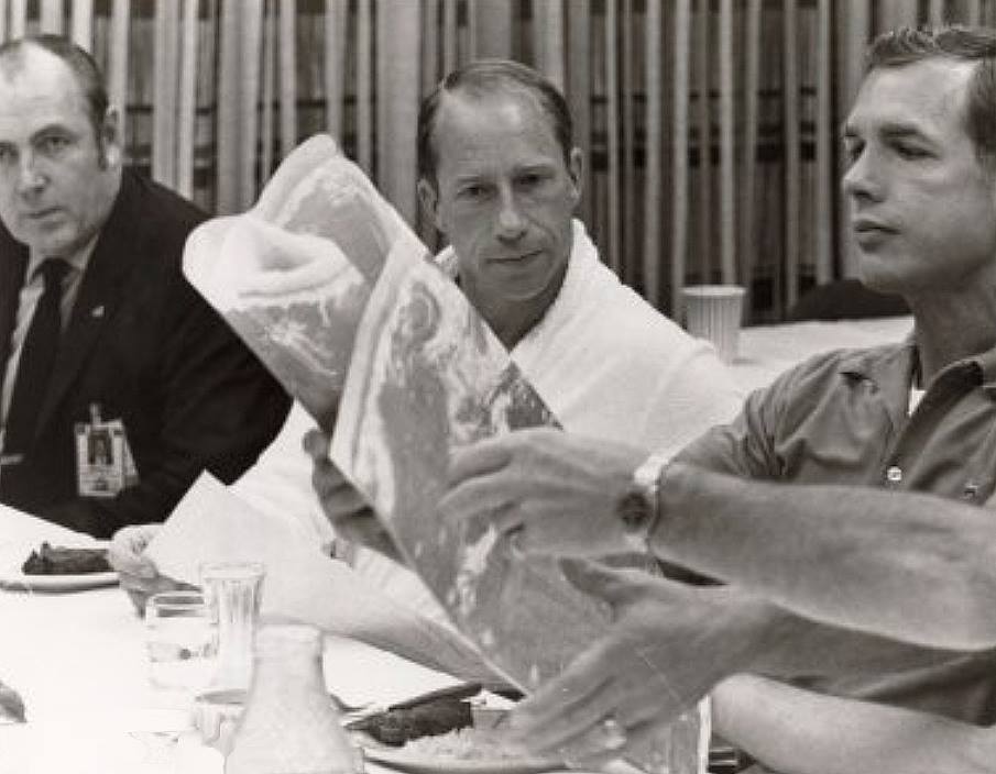
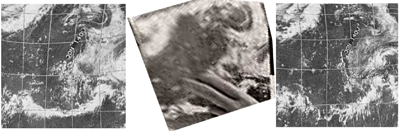
Like Apollo 11, there is a breakfast photograph of the crew showing them looking at a weather satellite print-out. It is shown below in figure 4.7.0.1
Figure 4.7.0.1: ESSA satellite images from 25/07/71 (left), 26/07/70 (right), and map from the Apollo 15 breakfast (centre). All images have been stretched and rotated to fit a square image view.
It should be fairly obvious, but the closest match for the image being held by Commander Dave Scott is from the image on the left, the one taken the day before launch, rather than one taken on the day. The same view taken on launch day wouldn’t have been available for a minimum of 3 hours after they launched.
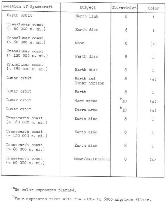
The mission also saw the use of Ultra Violet photography. This was carried out at set times, as shown in figure 4.7.0.3 – a reproduction of table 5.1 from the Apollo 15 Mission Report (ALSJ). Their aim, as detailed here, was to allow comparison with Earth images that would then allow interpretation of UV images of Mars and Venus.