4.8.0 - Apollo 16 Introduction

Apollo 16 saw another lunar rover head for the moon, this time in an exploration of the lunar highlands. It again involved several EVAs and the use of a CSM SIM bay to record experimental data in orbit while the LM carried its duties on the surface. UV photography was again employed to take images of Earth on the way to the Moon, and also from the lunar surface.

Even before this mission had begun, news reports were full of the next phase of NASA's space programme: the shuttle, and discussions on what to do with redundant launch towers were already under way. The economic cost of Apollo was freely discussed in these news programmes, and the perceived benefits of LEO satellite programmes became much more prominent in the discussions compared with the less immediately useful scientific data.

The flight was intended to launch in March, but technical problems with an explosive separation bolt between the LM and CSM forced a delay. The crew finally lifted off on April 16th 1972 and entered lunar orbit on the 19th. Landing did not occur until the 21st after more technical problems with the CSM engines caused a day's delay. After eventually landing and carrying out 3 EVAs, the surface crew were re-united with the orbiting CSM on the 24th. TEI occurred the next day, and the astronauts finally splashed down on the 27th. On the way back a televised EVA was carried out to retrieve data from the SIM bay, and an unmanned TV broadcast was also made from the lunar surface.

The mission timeline can be found here: NASA source.

As with Apollo 11, the existence of images from the lunar surface means we can generate ephemeris values from a batch file submitted to JPL Horizons to generate data showing where Earth should have been in the lunar sky, and what should have been on view.

Here’s the batch file submitted:

!$$SOF

COMMAND= '399'

MAKE_EPHEM = 'YES'

EPHEM_TYPE = 'OBS'

CENTER= 'coord@301'

COORD_TYPE= 'GEODETIC'

SITE_COORD= '15.50099, -8.97738, 0'

START_TIME= '1972-04-21 02:00'

STOP_TIME= '1972-04-24 02:00'

STEP_SIZE= '1 h'

QUANTITIES = '4,14'

REF_FRAME= 'IAU_MOON'

!$$EO


And here’s the output for their time on the surface:

*******************************************************************************

 Date__(UT)__HR:MN     Azi____(a-app)___Elev  ObsSub-LON ObsSub-LAT

*******************************************************************

$$SOE

 1972-Apr-21 02:00 *i  319.640044  77.146426  250.665854  17.830630

 1972-Apr-21 03:00 *i  319.769350  77.090333  236.156449  17.646273

 1972-Apr-21 04:00 *i  319.895095  77.033913  221.645357  17.460699

 1972-Apr-21 05:00 *i  320.017323  76.977175  207.132594  17.273932

 1972-Apr-21 06:00 *i  320.136077  76.920132  192.618173  17.085992

 1972-Apr-21 07:00 *i  320.251402  76.862794  178.102111  16.896903

 1972-Apr-21 08:00 *i  320.363340  76.805173  163.584420  16.706684

 1972-Apr-21 09:00 *i  320.471936  76.747280  149.065118  16.515358

 1972-Apr-21 10:00 *i  320.577234  76.689124  134.544218  16.322946

 1972-Apr-21 11:00 *i  320.679277  76.630717  120.021737  16.129468

 1972-Apr-21 12:00 *i  320.778111  76.572068  105.497691  15.934946

 1972-Apr-21 13:00 *i  320.873778  76.513189   90.972095  15.739400

 1972-Apr-21 14:00 *i  320.966324  76.454088   76.444966  15.542851

 1972-Apr-21 15:00 *i  321.055790  76.394776   61.916320  15.345318

 1972-Apr-21 16:00 *i  321.142222  76.335263   47.386174  15.146823

 1972-Apr-21 17:00 *i  321.225662  76.275557   32.854545  14.947384

 1972-Apr-21 18:00 *i  321.306154  76.215669   18.321449  14.747022

 1972-Apr-21 19:00 *i  321.383740  76.155607    3.786903  14.545756

 1972-Apr-21 20:00 *i  321.458464  76.095381  349.250925  14.343606

 1972-Apr-21 21:00 *i  321.530367  76.034999  334.713532  14.140591

 1972-Apr-21 22:00 *i  321.599491  75.974471  320.174741  13.936729

 1972-Apr-21 23:00 *i  321.665878  75.913804  305.634570  13.732041

 1972-Apr-22 00:00 *i  321.729570  75.853008  291.093037  13.526543

 1972-Apr-22 01:00 *i  321.790607  75.792091  276.550159  13.320256

 1972-Apr-22 02:00 *i  321.849030  75.731061  262.005955  13.113197

 1972-Apr-22 03:00 *i  321.904879  75.669925  247.460441  12.905385

 1972-Apr-22 04:00 *i  321.958193  75.608693  232.913637  12.696838

 1972-Apr-22 05:00 *i  322.009013  75.547372  218.365561  12.487573

 1972-Apr-22 06:00 *i  322.057376  75.485969  203.816229  12.277608

 1972-Apr-22 07:00 *i  322.103321  75.424493  189.265662  12.066961

 1972-Apr-22 08:00 *i  322.146886  75.362950  174.713877  11.855650

 1972-Apr-22 09:00 *i  322.188109  75.301348  160.160892  11.643691

 1972-Apr-22 10:00 *i  322.227026  75.239694  145.606727  11.431102

 1972-Apr-22 11:00 *i  322.263673  75.177996  131.051398  11.217900

 1972-Apr-22 12:00 *i  322.298087  75.116260  116.494926  11.004101

 1972-Apr-22 13:00 *i  322.330303  75.054494  101.937328  10.789722

 1972-Apr-22 14:00 *i  322.360357  74.992703   87.378624  10.574780

 1972-Apr-22 15:00 *i  322.388281  74.930895   72.818831  10.359292

 1972-Apr-22 16:00 *i  322.414111  74.869076   58.257969  10.143272

 1972-Apr-22 17:00 *i  322.437880  74.807253   43.696055   9.926739

 1972-Apr-22 18:00 *i  322.459620  74.745432   29.133110   9.709707

 1972-Apr-22 19:00 *i  322.479365  74.683619   14.569150   9.492192

 1972-Apr-22 20:00 *i  322.497145  74.621821    0.004196   9.274210

 1972-Apr-22 21:00 *i  322.512992  74.560043  345.438266   9.055777

 1972-Apr-22 22:00 *i  322.526937  74.498292  330.871378   8.836909

 1972-Apr-22 23:00 *i  322.539011  74.436573  316.303551   8.617620

 1972-Apr-23 00:00 *i  322.549243  74.374892  301.734804   8.397926

 1972-Apr-23 01:00 *i  322.557662  74.313254  287.165156   8.177842

 1972-Apr-23 02:00 *i  322.564297  74.251667  272.594625   7.957382

 1972-Apr-23 03:00 *i  322.569176  74.190133  258.023230   7.736563

 1972-Apr-23 04:00 *i  322.572328  74.128660  243.450990   7.515399

 1972-Apr-23 05:00 *i  322.573779  74.067253  228.877923   7.293903

 1972-Apr-23 06:00 *i  322.573555  74.005916  214.304048   7.072092

 1972-Apr-23 07:00 *i  322.571685  73.944656  199.729383   6.849979

 1972-Apr-23 08:00 *i  322.568192  73.883476  185.153947   6.627579

 1972-Apr-23 09:00 *i  322.563103  73.822382  170.577758   6.404906

 1972-Apr-23 10:00 *i  322.556441  73.761380  156.000836   6.181974

 1972-Apr-23 11:00 *i  322.548233  73.700473  141.423199   5.958798

 1972-Apr-23 12:00 *i  322.538500  73.639666  126.844864   5.735391

 1972-Apr-23 13:00 *i  322.527267  73.578964  112.265851   5.511767

 1972-Apr-23 14:00 *i  322.514556  73.518373   97.686177   5.287940

 1972-Apr-23 15:00 *i  322.500391  73.457895   83.105861   5.063924

 1972-Apr-23 16:00 *i  322.484792  73.397536   68.524922   4.839732

 1972-Apr-23 17:00 *i  322.467781  73.337300   53.943378   4.615379

 1972-Apr-23 18:00 *i  322.449380  73.277192   39.361246   4.390877

 1972-Apr-23 19:00 *i  322.429609  73.217215   24.778545   4.166240

 1972-Apr-23 20:00 *i  322.408488  73.157374   10.195293   3.941481

 1972-Apr-23 21:00 *i  322.386038  73.097673  355.611509   3.716614

 1972-Apr-23 22:00 *i  322.362276  73.038115  341.027210   3.491652

 1972-Apr-23 23:00 *i  322.337223  72.978706  326.442414   3.266607

 1972-Apr-24 00:00 *i  322.310896  72.919448  311.857139   3.041494

 1972-Apr-24 01:00 *i  322.283314  72.860345  297.271403   2.816325

 1972-Apr-24 02:00 *i  322.254495  72.801402  282.685224   2.591113

$$EOE

*******************************************************************************

After the date, the columns represent the azimuth and elevation of Earth from the lunar module’s location, and the Observer sub-longitude and latitude, ie the centre point of the Earth as viewed from the observer’s point on the moon at the time of the observation.

As far as mission photographs go, the AIA records that the Hasselblads took 22 magazines if film, with a total of 2808 photographs exposed. An additional magazine comprises the far right UV spectrum long exposure images taken from the surface.

A mixture of sources will be used, choosing the best resolution image available

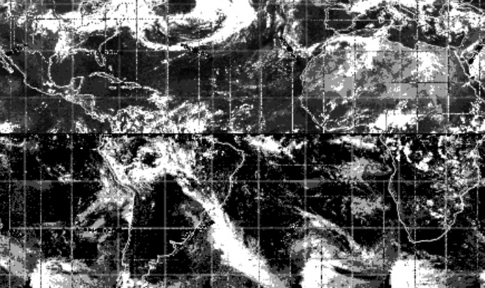
In terms of availability of satellite images, only ESSA 9 photographs have a full catalogue online, available here. ATS-3 images were still being transmitted, and one can be found here in the MWL for April 18th. An ESSA 8 image for launch day can be found here, in an interesting article about the ARIA (Apollo Range Instrumented Aircraft) that collected meteorological data in support of Apollo missions. ARIA is mentioned several times in the early part of the mission in Earth orbit (see the Mission Transcript here), acting as a relay between receiving stations on the ground. NIMBUS exposure data are recorded here, but no images are given.

The ESSA image in the article was taken on launch day, but unfortunately the area of the south Pacific shown is not covered by any of the photographs from that day. Understandably, the crew will have been a little busy at TEI and would not have had the time to photograph it.

We also have this pair of contemporary ESSA images (figure 4.8.0.1) published by the UK’s The Guardian, published on this site (and reproduced with the kind permission of the owner). Hopefully they’ll be of use, but they are again an indication of how freely available these images were. The Guardian obtained their photographs from Ambassador College, an offshoot of an American religious University that set up in the UK, not from ESSA or NASA.

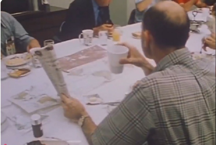
It’s not ideal, given how much of the still image is covered by breakfast paraphernalia, but it would seem to be a reasonable guess. The view from the video footage seems more conclusive, with one section showing north America, and the other covering Africa and the Atlantic.

Now for the main meal. Click the links below or at the top of this page to see the analyses.

CATM Home OBM Home
Intro Day 1 - 16/04/72 Day 2 - 17/04/72 Day 3 - 18/04/72 Day 4 - 19/04/72 Day 5 - 20/04/72 Day 6 - 21/04/72 Day 7 - 22/04/72 Day 9 - 24/04/72 Day 10 - 25/04/72 Day 12 - 27/04/72 Synoptic

Figure 4.8.0.1: ESSA satellite images printed in The Guardian, with comparisons to pdf versions of the compiled weather data. Source.

Intro Day 1 - 16/04/72 Day 2 - 17/04/72 Day 3 - 18/04/72 Day 4 - 19/04/72 Day 5 - 20/04/72 Day 6 - 21/04/72 Day 7 - 22/04/72 Day 9 - 24/04/72 Day 10 - 25/04/72 Day 12 - 27/04/72 Synoptic

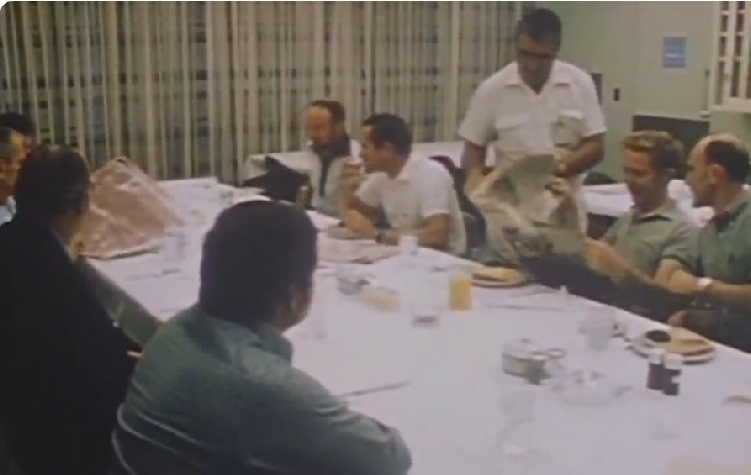
As with other missions, the pre-launch breakfast features a satellite image on the table as the crew are briefed before suiting up. Figure 4.8.0.2 shows a photograph of the breakfast scene, as well as stills from video footage of it.


Figure 4.8.0.2: Pre-launch breakfast and close-up of the satellite photo. Source.

It’s difficult to be certain, but compared with other breakfast photos it appears that it is laid lengthways along the table, at right angles to the photographer. We also can be certain that it isn’t from the launch day itself, given the schedule for ESSA’s image collection. The odds are that it is from the previous day, April 15th.

Assuming they are, as usual, interested in the weather over launch, the best estimate for what the various photos are showing is given in figure 4.8.0.3.

Figure 4.8.0.3: Estimate of satellite photo coverage from the breakfast photograph

CATM Home OBM Home