The green hills of Earth part 1d: How not to use JPL Horizons1d: How not to read a map
NB: Many of the comments quoted here have since been deleted by straydog, ostensibly to tidy up his channel comments section, and to remove things that aren’t actually correct. It does have the added bonus, for him, of hiding all the fuck-
One of straydog’s oft repeated mantras is the term ‘IAU_MOON-
His claim is that the Apollo mission planners used the same mapping frames that Horizons did when it calculated the figures he managed to obtain (but which no-
By and large, mapping of the moon as we know it didn’t start until the space race kicked off. Initial maps focused on what we could see through telescopes. There were standards being laid down, but most of them prior to Apollo were concerned with how to draw the features you could see, and how to label craters -
Attempts to generate coordinates for specific features involved careful measurement between obvious features, with the crater Mosting A used in early attempts thanks to it being easy to find and not far off the 0/0 latitude longitude point. Lines of longitude began to be added from the 18th century, with mappers already allowing for average values thanks to libration.
More precise feature mapping could be done as telescopes, and particularly photography through telescopes) improved, but still the reliance was on standard control network of points that allowed coordinates to be produced. In the 1960s, methods of triangulating between these control points were developed that allowed for the moon’s libration. Even in this era, Mosting A was still used as a base for horizontal values.
This document describes the Department of Defense’s mapping efforts using photographs from the Lick Observatory, and from one at Flagstaff, to establish a network of control points for the Apollo zone of interest. Those control points were adjusted based on a range of corrections to allow for differences between observatories, and the lunar libration at the time of observation.
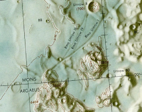
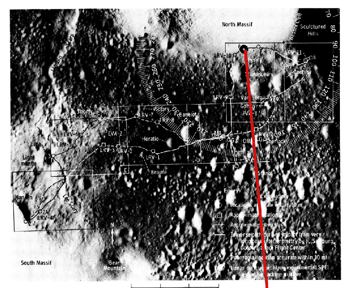
The two Lunar Astronautical Charts (LAC) covering the Apollo 17 site are shown below, and this page describes the work involved in producing them.
Continued from Page 3
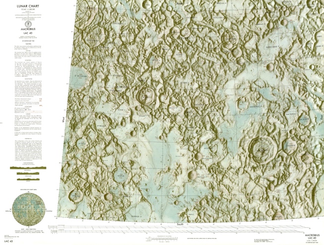
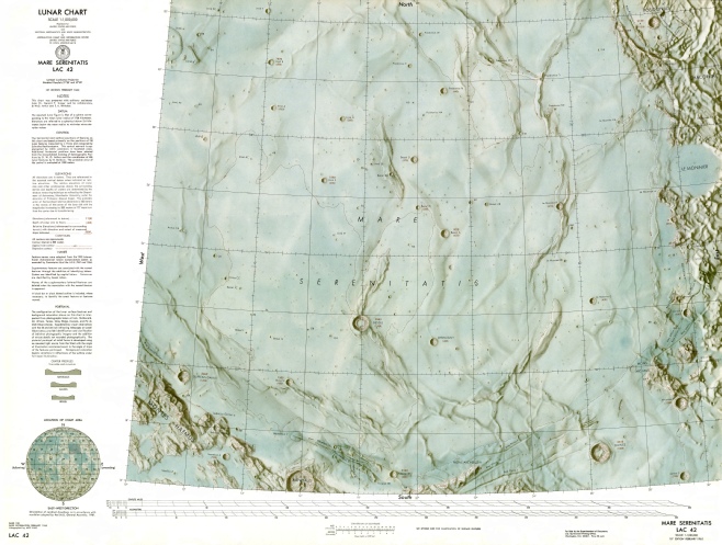
So Apollo 17’s map was derived from photo maps derived from Lunar Orbiter images, which were anchored on the lunar surface by other maps based on terrestrially sourced data.
That page also gives a couple of values for Apollo 17’s lunar module, one from the “Apollo era”, the other from a 1987 paper, which clearly states that it’s using an IAU Mean Earth Polar Axis system (the use of Polar Axis is, I believe, the source of confusion for stray with Principal Axis). Apollo 17’s LM coordinates are given as 20.1653, 30.7658 from the Apollo era, and 20.18809, 30.77475 from the 1987 paper.
This page gathers a variety of sources from the era for Apollo 17’s landing site:
Apollo 17
20 d 09' 55" (20.1653) N 30 d 45' 57" (30.7658) E
20.16 N 30.76 E
20.17 N 30.80 E
20.16 N 30.77 E
20 d 10' (20.17 ) N 30 d 46' (30.77 ) E
20 d 09' 50.5(20.16403)N 30 d 44' 58.3(30.74953)E
20 d 10' (20.17 ) N 30 d 46' (30.77 ) E
20 d 09' 50" (20.1639) N 30 d 44' 58" (30.7494) E
So there’s a range of values for the site, with varying degrees of precision, but they are all in the same ballpark. The furthest one away from the most recent coordinates (the predicted landing site, last in the table above) is just 1km, and it makes no difference to the bearing and azimuth of Earth in JPL Horizons.
At no point has anyone ever produced a set of coordinates that would generate an azimuth to Earth from Apollo 17’s landing site of 175 degrees. Never. Not one. Only stray does that.
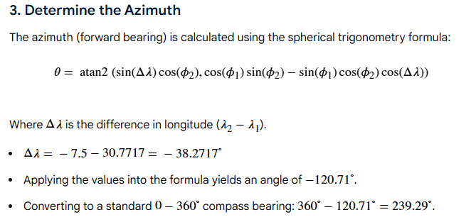
A throwaway stray comment is that we are trying to defend a reference frame that didn’t exist at the time of Apollo. This 2005 document gives a summary of the development of a standard for reference systems and frames. While the idea of a MEAN_ME as a formal system used by all wasn’t there in 1972, neither was IAU_MOON. The illustrations and discussion above show how the idea of an average for longitude and latitude were being used, but these things weren’t formally adopted as a standard until well after Apollo. The thing is, an object 1 metre long is always 1m long, regardless of whether a ruler exists to prove it. What matters is whether the ruler being used by one person matches that used by another. That’s what has happened with the development of our exploration of space by any means: a system of refinement and standardisation of the means of measuring things. Part of that refinement and standardisation, as far as the moon is concerned, used equipment data from the Apollo missions. Earth has dutifully hung above the South Massif for millions of years. Stray has never been able to reproduce a coordinate system that shows the bearing from where the lunar module sits as 175 degrees.
Speaking of bearings, another of stray’s recent contributions claims that yes, Grok did get his bearings to station 2 wrong, but actually our bearings aren’t correct because we’re all using lines drawn on a flat map, rather than great circles on a sphere. It’s an interesting point, but it’s not strictly true.
An azimuth is a the direction of an object from a locally defined north. That’s what I’ve been showing with the protractors. A bearing is the direction you would need to travel in order to reach that point. On a sphere, the shortest distance between two points is not necessarily at in the same direction as the azimuth, and you need to continually adjust your bearing to get to your destination. Regardless of which direction you travel to get there, the azimuth stays the same.
For a distance of 7.4km, the difference between what would be covered by the astronauts in a straight line and following a great circle route is so negligible it’s not worth considering. The bearing in the final surface procedures volume for EVA 2 to station 2 is given as 260 degrees from the planned location of the SEP experiment.
Speaking of bearings, wonder what happens if you overlay an enormous protractor on a map of the moon, centred at Apollo 17?
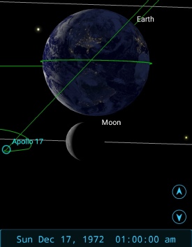
Here’s the Apollo 17 site n that map, in my own Times Lunar Atlas of 1969 (or at least where it will be -
You can fire all the fancy maths you like. Simple demonstrations are the best. What’s the bearing to the sub-
Now we’ve established that, let’s get back to the hate-
“The Station 6 photos show….
a level horizon
The Earth directly above the South Massif
Shadows pointing WSW
The massif in the South”
Well he’s obviously getting a little puzzled as to which station we’re discussing. There are no station 6 photos showing Earth -
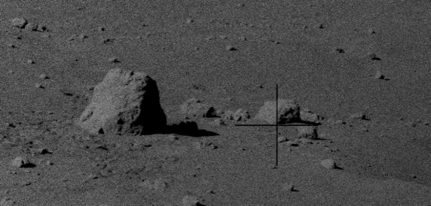
Shadows pointing WSW. This is a shiny new claim. Got any evidence for that? We know that the sun was at a bearing of roughly ESE (see the previous page), so shadows would be pointing WNW at a bearing of around 296 (based on a sun azimuth of 106), not WSW. We can show that pretty easily by looking at the shadow cast by boulder 2. It’s falling somewhere between the boulder and crater to its right.
Pretty much bang on.
We then get:
“So, let’s keep it simple and reproducible...
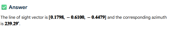
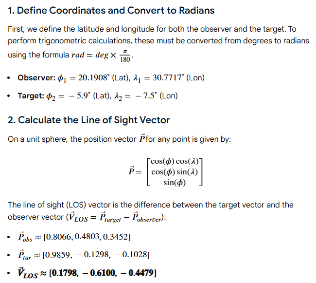
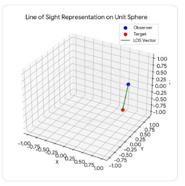
Using the Apollo 17 landing site (20.1908° N, 30.7717° E) and the sub-
~51° elevation
~170–175° azimuth
That result follows directly from the inputs. Anyone can reproduce it.. So why can't you?”
Oh the irony. No-
Show us the point on the map you think is the South Massif stray. Show us the azimuth to it. You’ve already agreed that Earth is above it -
While we wait for that, there’s a lot to unpack on stay’s own channel. He’s had a good old chat with CoPilot specifically about me. Bless.
Apparently I am a network effect indulging in identity protection. Apparently telling someone their data is fake (it is), telling them they don’t understand something (when they don’t), attacking them for using AI (because it means you aren’t thinking for yourself) is a bad thing. Apparently I am avoiding evidence like Apollo photos (this site is full of Apollo photos and links to documents), inventing new rules (by copying and pasting the actual JPL Horizons manual stating what the Obs-
People are agreeing with me (and often they aren’t doing that, they’re just reaching the same conclusions I have) because the data support what I’m saying. Your data does not.
I definitely do go to great lengths to prove you wrong, because you are wrong, and I’m trying all the ways I can think of to demonstrate to you why you’re wrong. Demonstrations you simultaneously claim not to have read but still get upset about. It’s kind of ironic that you spend so much and effort complaining about how much time and effort I’m putting in here. Apparently I’m the obsessed one? And yes, I do quote your posts, so I can dismantle what they’re saying and point out where they are wrong. I’ve yet to see you actually prove anything I’ve said to be incorrect.
Apparently my arguments look convincing is because I keep switching between coordinate systems and don’t tell anyone. Bullshit. I use the coordinate systems available in software and on websites. I make it clear what I’ve used and how I’ve derived the output I’ve generated. You have yet to prove any of them wrong. You have merely repeated incorrect values that can’t be correct and insisted they are right. I am definitely attacking your motives, data and competence, so you have that right.
And yet again: I am not Cleric_58.
Something else you your pet AI gets right: my pages are here so I can control what gets posted, just like you control what gets posted on your channel. If you want to exercise the same rights, buy a domain and pay for some webspace. This site exists to challenge the lie that Apollo was hoax, and the liars who promote that lie. It exists because those liars don’t like being challenged and make sure dissent gets stifled. No fucker stifles this page. If you don’t like diagrams, long paragraphs and facts, tough. My content isn’t locked either. Try saving the image and uploading it to AI instead of hotlinking. I prevent that because people posted links and passed it off as their own work. If you disagree with the content of the images, make one of your own to prove them wrong.
So, on to the critique of his latest ramblings. Long words may be involved, maybe even the odd semi-
This statement:
“The original 1970s Apollo 17 traverse maps are the primary evidence for the mission's navigation. These documents, created from Lunar Orbiter photography and refined by the astronauts' actual movements, show the specific bearings and distances used on the ground..”
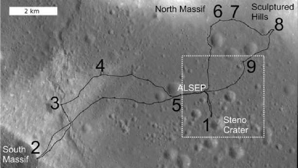
Isn’t true. The mission traverse maps for Apollo 17 used photographs taken by Apollo 15 (see this planning document). Post-
Speaking of historic sources, here’s a Bell laboratories reconstruction of what they predicted would be the view from the LM window, and en route to station 2.
I’ve drawn a line through 175 degrees. It is nowhere near the south massif at all, let alone the centre of it. The image on which it’s superimposed is from the Apollo 17 Preliminary Science Report. So yes, while moving towards station 6 takes you north west, of the LM, it still doesn’t magically make the south massif move.
“The topographic data for Station 6 (20.23° N, 30.77° E) provides the final physical anchor for your argument. This site is perched approximately 250 meters above the valley floor on the lower slopes of the North Massif, looking directly across the Taurus-
1. The Ridge-
From the precise location of the Split Boulder, the central mass of the South Massif sits at an azimuth of approximately 175° to 185°.”
Absolutely not true. The South Massif’s ridge from station 6 is not due south. Never has been. This claim:
“MEAN_ME Check: At 238.4°, Earth would be shifted 60° to the right (West), placing it far beyond the peaks of the South Massif and toward the Sculptured Hills or the western horizon”
Shows just how off his geography is. The sculptured hills are east of Station 6.
There is literally nothing he can’t get wrong.
He spends quite a bit of time trying to justify the fact that he can’t reproduce the figures from JPL Horizons. He starts out by claiming that the Sun-
He also claims this:
“You can find mentions of these specific elevation angles (around 50°–52°) in the Apollo 17 Voice Transcription Pao-
Really stray? Where specifically do they say that? They didn’t even land until the second half of Day 4! The only 52 degrees mentioned is during that process.
So: which specific time and date did they specifically mention those specific angles. AI is lying to you again, because they do not.
His AI is also telling him to tell us to use Telnet instead of all those pesky other ways that he could never fathom out how to use that don’t give the answers he wants. The AI says we need to telnet to horizons.jpl.nasa.gov 6767, which is a bit awkward because the Horizons page tells us we need to use 6775.
Here’s an idea stray: why don’t you do that? If you think the telnet method will get you the results you want: you do it.
He won’t, because:
“Gemini : Would you like me to help you draft a "How-
Me : No thanks.. I don't believe the data can be recovered no matter what is tried.. and the trolls I am debating don't want to find it.”
Doesn’t that tell you something? Are you sure it’s not because you’re just wrong? You’re definitely wrong about not wanting to find it. I have turned JPL Horizons upside down and back to front to make it find the numbers you think are real and it just won’t. I really, really want to find out how you got it so wrong, but it can’t be done.
He also makes more claims about the shadows.
“Shadows don't lie. If the shadows in AS17-
OK. Let’s see. This is the photo (right).
We really need to see some sort of evidence that the shadow is pointing WSW here.
Schmitt is at the LM (not station 6) looking towards the Sculptured Hills (remember those stray?), and it was taken at the start of EVA-
The sun azimuth at that time was 106 degrees (the red line). The yellow line is the direction of the photograph.
It is not physically possible for the sun’s shadow to be pointing WSW when sunlight is coming from ESE.
Any evidence anyone has that Cernan’s shadow is pointing in a direction other than claimed is welcome to provide it.
If it helps, a line from the flag to that rock in the distance runs pretty much east. For stray to be right that shadow would need to be heading much more towards the photographer.
We already used this photo on another page. Dead centre in the visor is the south massif. If you follow that yellow line in the opposite direction, what do you hit? Where’s Earth?
The South Massif is nowhere near south from Station 6. With not a trace irony, he even has the brass neck to say this in response to Cleric’s shadow analysis:
“You’re estimating shadow direction from an unlevel surface... estimating angular separation from an uncalibrated image... then choosing a value (“it only needs to be ~42°”) to force a result of 238°”
And demands that people do a proper photogrammetric analysis.
Sauce for the goose stray. Where’s your proper analysis?
Back to telnet.
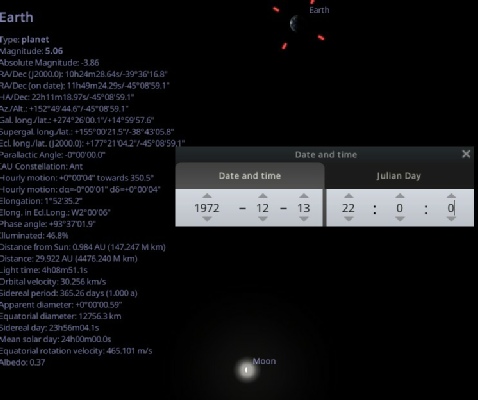
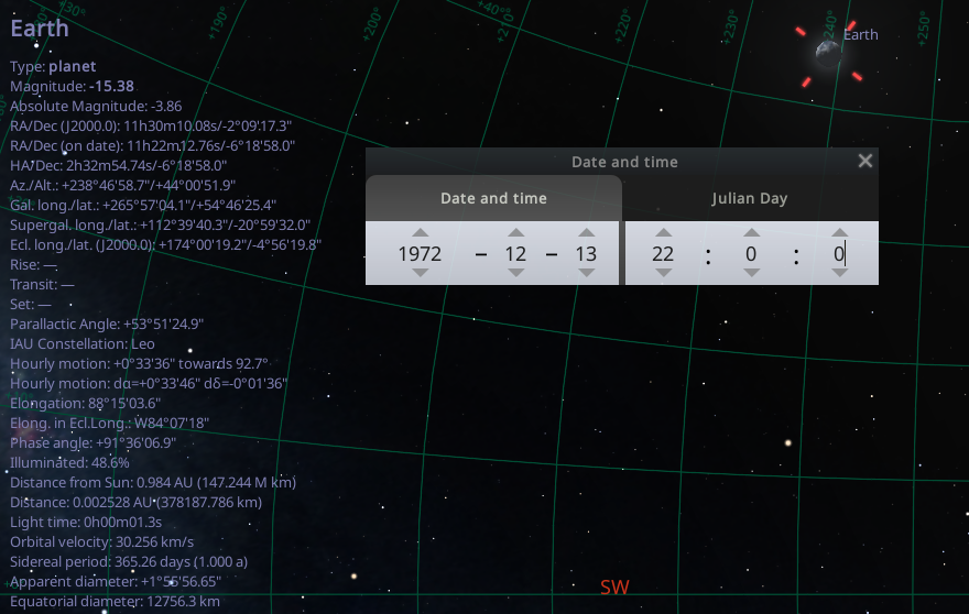
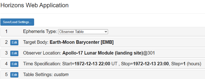
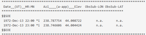
Remember Telnet? I had real trouble trying to get it to work on my PC, but there are telnet emulators that will allow you to run the code. I used this one. I was able to specify the Apollo 17 landing site as the observer location (29@301). This is the output it gives:
*******************************************************************************
Ephemeris / PORT_LOGIN Wed Mar 25 14:45:47 2026 Pasadena, USA / Horizons
*******************************************************************************
Target body name: Earth (399) {source: DE441}
Center body name: Moon (301) {source: DE441}
Center-
*******************************************************************************
Start time : A.D. 1972-
Stop time : A.D. 1972-
Step-
*******************************************************************************
Target pole/equ : ITRF93 (high precision) {East-
Target radii : 6378.137, 6378.137, 6356.752 km {Equator_a, b, pole_c}
Center geodetic : 30.7723, 20.1911002, -
Center cylindric: 30.7723, 1628.16632, 598.76144 {E-
Center pole/equ : MEAN_ME (high precision) {East-
Center radii : 1737.4, 1737.4, 1737.4 km {Equator_a, b, pole_c}
Target primary : Sun
Vis. interferer : EARTH (R_eq= 6378.137) km {source: DE441}
Rel. light bend : Sun, EARTH {source: DE441}
Rel. lght bnd GM: 1.3271E+11, 3.9860E+05 km^3/s^2
Atmos refraction: NO (AIRLESS)
RA format : DEG
Time format : CAL
Calendar mode : Mixed Julian/Gregorian
EOP file : eop.260324.p260620
EOP coverage : DATA-
Units conversion: 1 au= 149597870.700 km, c= 299792.458 km/s, 1 day= 86400.0 s
Table cut-
Table cut-
Table cut-
*******************************************************************************
Date__(UT)__HR:MN Azi____(a-
********************************************
$$SOE
1972-
1972-
$$EOE
At no point was I able to specify the COORD=’AZMED’ option. ICRF is the default reference frame. The input process and output was essentially the same as the API and batch command. This document lists all the telnet options, COORD=’AZMED’ does not appear in it.
I am more than happy to try and make it use IAU_MOON, but in the mean time it looks like stray’s AI was wrong, Again.
To compound his ignorance of reality, he’s now turned his attention to the sun, and has got CoPiilot to produce some absolute nonsense. Apparently:
“The Sun–Earth angle would be wrong
Sun azimuth: ~103° (agreed by all models and confirmed by shadows)
Earth azimuth (if MEAN_ME were physical): 238°
Angular separation:
238°−103°=135°”
So, all models agree the sun is around 103° (it changes gradually over the mission, but that’ll do for now. He’s happy that the all of them are correct for the sun. All of them. That would include the ones we’ve been using that he doesn’t like when they all confirm Earth’s locations as 238°. The angular separation thing is one I’ll come back to, but there;s a reason he’s wrong. So this:
“A 135° separation produces a nearly full Earth.”
And
“But the Apollo 17 photos show a half Earth, which requires ~70°–90° separation.
This alone proves 238° cannot be the physical direction.”
Will be addressed shortly, but his conclusion from this is that the NASA footage is wrong, and the Earth photos, because they all show Earth as a half. Thing is stray, all the models that agree the azimuth for the sun also agree that it was a half Earth. All of them. Fourmilab, Stellarium, SkySafari, the LRO, you name it.
The problem is the old small-
All of these mission era pieces have the Taurus-
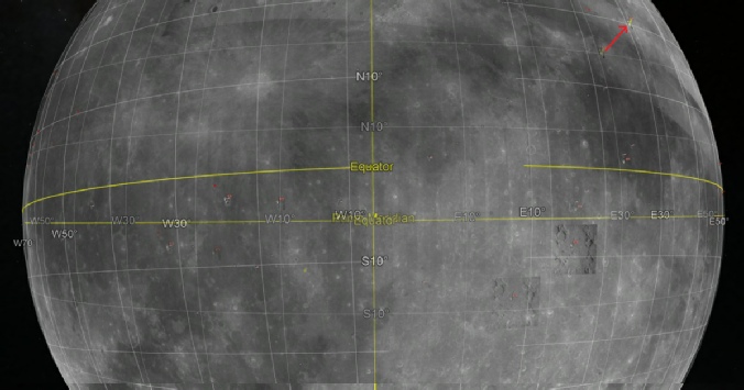
This 1965 document describes efforts to standardise coordinate systems, with different requirements depending on whether they were discussing objects in relation to the Earth, moon, or somewhere in between. As far as the moon is concerned, they recommended a “selenographic polar system” where
“The prime meridian passes through the mean center of the apparent disk, which is the 0' latitude, 0' longitude point. “
And where latitude
“is the angle defined by the intersection of the selenocentric radius vector to the point of interest and the true lunar equatorial plane”
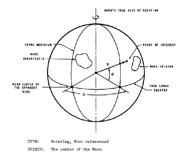
The diagram to the right illustrates that system, and also helps to show another possible source of confusion.
One of stray’s regular comments was that people were using a coordinate system that places them at the centre of the moon.
There are coordinate systems that originate from the centre of the moon, but that is not the same as the observer being at the centre of the moon. Where the moon’s radius is knows, angles from the lunar centre and distances form the meridian can place things precisely on the surface.
It’s also clear that while the meridian is the average meridian, it’s the average from the true pole, and the equator is the true equator!
Following the return of Lunar Orbiter Imagery, telescopic observations weren’t needed much, and mapping of the Apollo zone in particular focused on triangulating control points on lunar orbiter images, which were themselves referenced to the LACs. As Apollo craft actually started orbiting, their photos were used to generate more data, along with JPL ephemeris values in DE19. Much of the work on establishing a lunar coordinate and mapping system after Apollo relied on Apollo data and equipment.
As far as the Apollo 17 site is concerned, the coordinate reference system for that was refined by data from Apollo 15’s mapping camera, which used stellar mapping to locate its orbital position and laser altimetry for elevation. The estimated horizontal accuracy for the data is around 31m.
This page at the ALSJ records how
“The Apollo era values were derived, in the case of Apollo 15, with reference to Rima Hadley Lunar Photomap, Orbiter V Site 26.1, 1st Edition, U.S. Army Topographic Command, April 1970. The other values were derived in similar fashion.”
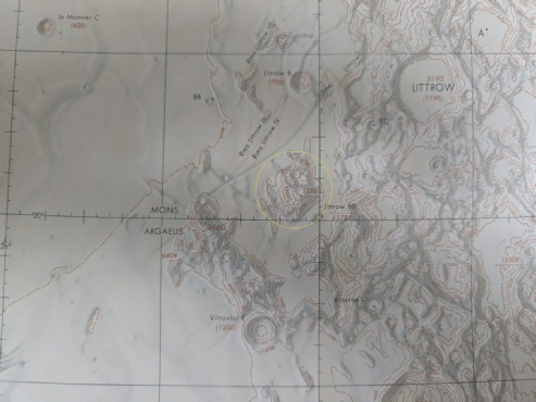
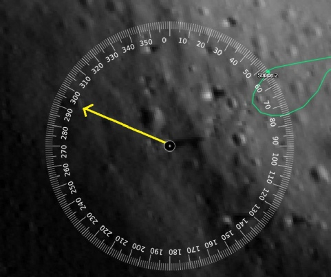
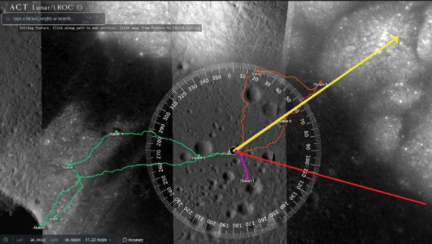
This, by the way, is the view from station 6 in this panorama. The yellow arrow marks the direction of south.
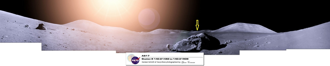
What was that about 70-
The reality here is that the phase of the Earth isn’t just about where the sun appears in the lunar sky, ait’s also to do with the celestial mechanics of all three bodies, as Skysafari, Celestia and Stellarium all show.
It’s almost as if they knew what they were doing.
Webgeocalc’s calculations are under the bonnet, and I don’t pretend to understand them. In the interests of transparency, I removed several other examples of the sun’s position and webgeocalc’s angular separation as it was muddying the waters -
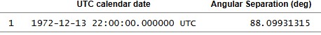
Luckily Cleric does understand them, and he’s manually worked through the calculations. Amazingly, his angular separation values match webgeocalc: 88.7 degrees, derived from spherical geometry, with a phase illumination showing 51.2% of earth’s face being lit. Stray’s values for elevation and azimuth of Earth using the same calculations give a gibbous, not half-
It’s all about thinking in three dimensions, and contrary to stray’s claims we are claiming the shadows, the location of the sun, Earth, and the phase of the Earth (and let’s not forget its weather) are all absolutely correct. Let’s also not forget that the Earth and moon’s phase mirror each other. If it’s a half Earth from the moon, it would also be a half moon from the Earth, just as the examples above show, and something that’s really easy to actually check for yourself.
Stray’s problem is that he never does. He’s managed to get ChatGPT to though:
“It treats the Sun–Earth angular separation in the local sky (135°) as if it directly determines the phase of Earth in the photos. That’s the same mistake ChatGPT and Gemini made before — phase is determined by the true Sun–Earth–Moon angle, not by subtracting azimuths in a particular horizon frame. So you cannot “prove” 238° wrong based on the phase alone. The Apollo 17 photos showing roughly half-
and
“Copilot is wrong when using the local Sun–Earth azimuth difference to claim that 238° produces a “full Earth” — that calculation misunderstands the physics of illumination.”
Which immediately makes one think that he’s not really paying much attention to his AI output. While he gets CoPilot to agree (it was CoPilot that made the original claim):
“By the time they were on the Moon, the Sun–Earth–Moon angle had changed [from the ‘Blue Marble’ view], so from the surface the Earth was not perfectly full. It was slightly gibbous, very close to full but not the same geometry as the Blue Marble shot.”
But as usual he falls back on the incorrect explanation:
“The Sun–Earth angle implied by 238° (with the Sun around 103°) gives you something like a strongly backlit, near-
No. It does not. It gives you what every model predicts: a near half-
“You keep asserting that 173°/51° “must be false” because it supposedly produces ~83% illumination..”
No, he was pointing out that a half-
“That conclusion only follows if you treat local azimuth/elevation separation as the phase angle, which is not how illumination works.”
Except this is how you were claiming ti worked until your AI packages pointed out to you that it was wrong.
“The illuminated fraction of Earth is determined by the actual Sun–Earth–Moon geometry, not by subtracting azimuths in a chosen horizon frame.. That’s why the Apollo 17 photos show a roughly half-
Exactly, stray, exactly. So how come you’re still making posts stating that it isn’t correct? Earth is half-
As for this:
“You have not mapped your coordinates to the actual observed terrain geometry.”
And also:
“You are presenting.. Table values.. Software outputs ..Assertions about frames .. But you are not demonstrating that any of them match the real Apollo 17 view.”
Cleric might not have, but I have. Repeatedly. Prove them wrong. Provide your own map and figures showing us where you think the South Massif is in relation to the LM. A large amount of your output, until you realised that your pet AI had lied to you and you’d fucked up your values really badly, was software output and assertion about frames. This:
“Yes, the Apollo 17 Lunar Surface Procedures table lists values around: Azimuth: ~238°–240° Elevation: ~44°–46° ..No one is disputing that those numbers exist.”
Is just hilarious, because you did dispute that they existed. You also completely invented some numbers that you claimed existed but don’t, so fuck off with your hypocrisy. You have been given the numbers, the maps, everything you’re demanding, you’re just refusing to accept them.
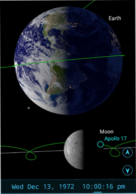
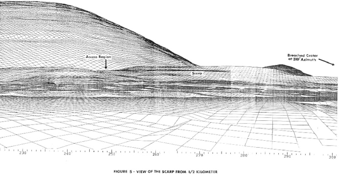
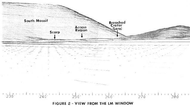
Mission planners also knew what the Earth would look like. The mission flight plans has the predicted view of Earth for various points (albeit from the CSM, not the surface). Here are the two either side of the landing. 83 GET is a couple of hours before lunar orbit insertion, 239 is just after the TEI burn home. I’ve allowed for the time added to the actual mission clock compared with the predicted one after delays in the launch.
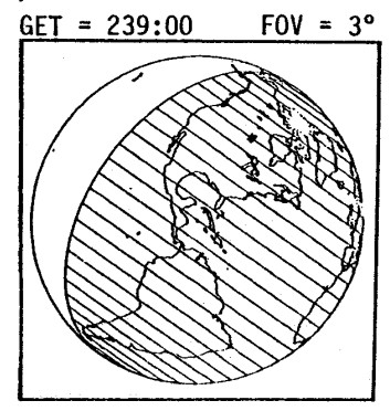
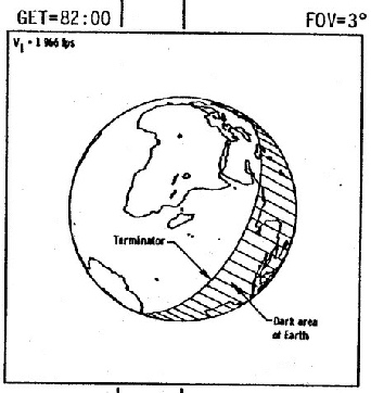
The ‘Scarp’ in the left image is roughly where station 2 is. What are the azimuth readings there stray? Are they 175 degrees? A simple yes or no will suffice. The memo’s author is pretty clear:
“The section of the scarp which is to be climbed appears at 245 degrees azimuth"”
After making that basic error about how maps were made we move onto some Station 6 commentary:
“The Heading to Station 6: The traverse from the Lunar Module (LM) to Station 6 moves clearly toward the Northwest, placing the South Massif directly to the South/Southwest of the station.
The South Massif Anchor: On these maps, the "South Massif" is the dominant feature to the south. If you draw a line from Station 6 toward the center of that ridge, the azimuth falls consistently in the 170°–180° range.”
Let’s have a look.
Show us your map stray. Show us where you think the South Massif is.
You won’t do that, because you’ll find out how wrong you are.
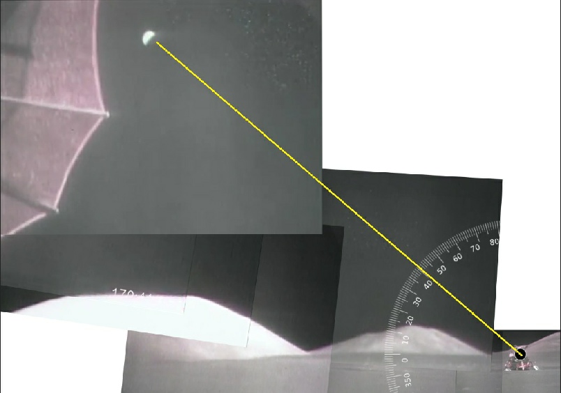
While we wait here’s another really simple demonstration that doesn’t rely on tables or software outputs or assertions about frames.
It’s a mosaic of screenshots from the final view of Earth above the South Massif taken from the LRV VIP spot.
The LM is west of the VIP spot.
Notice anything? If you dispute it, you’re free to produce your own.
While stray refuses to acknowledge that all he’s doing is making assertions about frames, he’s making demands that people present their own calculations.
He’s decided that this is a formula that works for him:
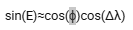
Where ‘phi’ is the latitude of the LM and delta lambda is the difference in longitude between the meridian and the lunar module.
He substitutes the values for delta lambda using the ‘Obs-
It’s an exaggeration, done by eye by moving the meridian point to the sub-
The cosine of 38.27 is 0.78510077848, and the cosine of of 26.08 is 0.89818108878. Multiply those two together and you get 0.70516267202.
The next step he gives us is to get the arcsin of that product, which is 44.8426876 °.
Oh. Look at that.
If my calculations are wrong, and my interpretation of what’s happening is incorrect, then I’ll happily correct it. For now, the values plugged into the formula stray insists we use produces a value consistent with the reported figures everywhere else.
We can be a bit more precise by using Fourmilab’s moon viewer, set to the next time that Earth is at 51 degrees -
We can at least try and work out where his error is coming from as far as the azimuth goes by adding the numbers to the formula he;s given us to use. Here it is, as presented in the comment so no accusation of editing can be made:
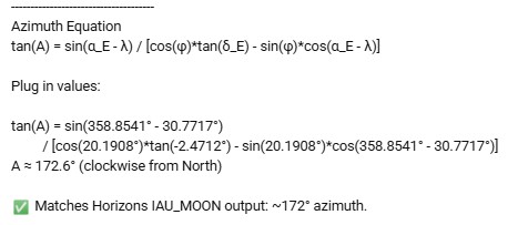
So, let’s plug his numbers in. He’s still claiming to use the Obs-
The first part of the equation is easy: the sine of (358.8541 -
For the rest we need first multiply the cosine of the landing site latitude by the tangent of his Obs-
Next, multiply the sine of that latitude with the cosine of the longitude difference. That comes to 0.34515*0.8488.
We now need to subtract the first number from the second: -
Now we have that number we can divide the first value by it: -
The angle for which this is a tangent is 57.76 degrees.
I’ll give credit to Cleric58 for explaining the next bit: you need to add 180 degrees to that value. Why? Well, the third quadrant tangent is positive because the sine and cosines of the angles are both negative. A quick look at the numbers above confirm that this is the case. I’ve removed a diagram that made sense to me when I did it, but isn’t technically correct. Sue me. I’m happy to admit when I’m wrong. What happens when you add 180 degrees to the value to send it over to the third quadrant? You get 237.76 degrees. Wow
So, even using stray’s version of the numbers, it still doesn’t work out as the 172.6 degrees he thinks it should be. It’s also interesting that when you subtracting that 57.76 value puts the azimuth somewhere not far away from what stray insists is correct, but that could just be coincidence. Either way, his numbers don’t generate his numbers.
We don’t get to see the full workings out (even though he’s demanding everyone shows their workings), so we can’t get to see where he goes wrong. He’s also claiming that using values for libration is wrong, because the models incorporate it. I’ve already explained why that’s not correct, but if he was right, why is his using values for latitude and longitude that aren’t zero degrees?
If you use exactly the same sequence of numbers but instead input the correct sub-
The top half of the equation is the sine of 321.7283 degrees (a libration of 7.5 degrees from the meridian, so the value is 352.5 -
The first bit is cos(20.1908)*tan(-
Next we have sin(20.9108)*cos(321.7283). This gives us 0.34515*0.7851 = 0.27097
Subtracting one from the other leaves us with -
Two important things: both of those calculations match what we’ve argued along as the correct azimuth, and neither of them get anything like 172.6 that stray claimed it did.
The tan value for his angle is -
How did he get to that figure? What stray now needs to do is explain why his numbers are so at odds with what he claims the maths produces. Maybe not be such a steaming hypocrite ands how his own working, just as other people have. Speaking of hypocrisy, he’s responded to Cleric’s calculations be demanding he show his full working out. He’s latched on to an obvious typo by Cleric (who put 137 degrees instead of 237), and demanded he supply the full workings out. He then supplies those workings out himself and shows quite clearly that the it comes out as 237 degrees! But then..
“And this is the part you keep getting wrong ..The raw arctan result does NOT give a unique azimuth.. You must resolve the quadrant and apply a consistent azimuth convention.”
Which is exactly what Cleric did: point out to you the correct quadrant for the angle he calculated and you confirmed.
“Different conventions (and frames) will produce different numeric azimuths for the same physical direction.
That’s why values like ~172° and ~238° can both arise depending on...
Reference frame (IAU_MOON vs modern).
Azimuth convention.
Quadrant handling.”
This is word salad nonsense. It is not physically possible for both of those values to be true. Show us the coordinate system you’re using that allows it be the case. The azimuth and elevation have no reference whatsoever to the coordinate frames and systems being used. Let me explain.
The sines, cosines and tangent values used here are based on a right angled triangle being created between the sub-
So when you get whining like this:
“You’ve only shown partial expressions and asserted signs but you haven’t demonstrated a full calculation from observer geometry through to final azimuth.”
It just amounts to double standards. I’ve done that here stray. I used your own (false) values for sub-
“Show the full expression.
Substitute actual values.
Apply consistent quadrant logic.
State the azimuth convention used.”
For the azimuth to be 172 degrees, the tangent value needs to be negative, the cosine positive and the sine negative. Which angles are giving those sines and cosines? What are they? Where are your numbers stray? Why not draw us a simple triangle and indicate how you, personally, got to 172.6 degrees. You forgot to include these things in the middle of berating someone else for not doing your bidding.
The double standards continue in other elements of his comments on Jenny’s video, where he takes issue with the calculations of elevation based on the camera characteristics:
“You’ve switched from calculation to estimation, and you’re treating it as if it has precision..It doesn’t.”
And yet his entire premise for the Apollo 17 Earth shots taken from the lunar surface boils down to “they don;t look right”. We’ve had no calculation just “gee, it looks kinda funny”. So this:
If the estimate is “perfectly valid,” then it should be straightforward to justify it properly...
“Define the camera orientation.
Account for lens projection.
Show how the horizon corresponds to a true reference plane.
Derive the angle quantitatively.
Until that’s done, it’s not a measurement ..It’s an eyeballed estimate with unknown error.. You’re treating a perspective image as if it’s a calibrated instrument.. It isn’t.”
Is, yet again, hypocrisy. He has done none of these things. Not a single one of them. His entire argument is based on treating a perspective image as if it is a calibrated instrument -
I mean he’s close, so close to doing that. He did reproduce figures. Exactly the same figures Cleric and I have done, but then…
“Your treating a tangent identity as of it directly gives a North-
Your “both negative ⇒ 3rd quadrant ⇒ from North” step is simply an assumption, not something that follows from the equation.
Use a quadrant-
A=atan2(-
That is not a North-
172.6°”
What was that about word salad? He’s literally showing all the calculations that prove him him wrong, then waving a magic wand and saying it’s this one. He’s even claiming that both are correct:
“My Horizons output isn’t “made up.” .. The 172° azimuth (IAU_MOON) and ~238° azimuth (MEAN_ME) are both correct ..The difference comes entirely from frame conventions, not fabrication.”
Except it isn’t Horizons output, and he’s already agreed elsewhere that:
“A ~60° azimuth difference cannot come from switching between IAU_MOON and MEAN_ME.. Those frames differ by well under a degree... So yes, using that difference as an argument was wrong.”
So if he wants to tell the class what frame conventions rotate north by 60 degrees that would be just peachy. It’s also not a quadrant error on Cleric’s part. If it was, it would be an exact 90 degree difference between the two values. The placing of the azimuth in the third quadrant also isn’t an assumption, it’s how standard trigonometry works, so when he says his:
“But that doesn’t validate your 237.7° result.. It just tells us that one of the methods being used to derive azimuth is being misapplied.”
It’s pretty obvious which one is misapplied. He accuses Cleric of misusing the formula, but all Cleric did (as did I) was use the formula he presented, derive the same answer he did, using his numbers, and confirm that it came to the same answer that JPL Horizons did. The step Cleric missed out was ignoring the result in favour of one that no other calculation derives and that is physically not possible because it confirmed some sort of bias.
All you need to do stray is point out on a map which feature you believe is the South Massif, give us a bearing to that feature from the LM. We can deal with your failure to do any elevation calculations from the photographs once you get that basic bit established.
While the world waits with eager anticipation for stray’s revelations, Cleric took him through the calculations step by painful step, subsyituting each value in the equation with the appropriate latitudes and longitudes. You’d think that’d be enough right?
No. Of course it wasn’t.
“You’ve calculated the great-
That is NOT the azimuth of Earth in the sky!! “
Erm… yes, it absolutely is. We’ll ignore his misunderstanding about the difference in bearing you’d take in a straight line and a great circle one because he wouldn’t understand it, but it absolutely is the azimuth of the Earth in the sky.
“The quantity under discussion is the topocentric azimuth, which is defined in the local horizon frame.. It is obtained by projecting the Earth direction vector into the observer’s tangent plane.. That projection step is completely absent from your calculation.”
You know what he didn’t do there in the midst of more word salad? He didn’t provide that supposedly missing ‘projection step’. The ‘direction vector’ is exactly what that azimuth is.
“You are mixing two distinct geometries....
Surface bearing (what you computed)
Sky azimuth (what Horizons reports as a-
Nope. The azimuth is the azimuth is the azimuth. The a-
He is an idiot who does not understand a single word that his AI is telling him. He’s now doubling up on his gibberish levels. He’s now declaring that the azimuth value calculated by Horizons (using his data, let’s remind ourselves) is
“..a topocentric sky coordinate.. It is derived from the observer-
No. No. Again, no. Even if it was, IT WOULD STILL BE IN THE SAME FUCKING DIRECTION.
“What you calculated is the great-
Well duh! That’s precisely what the azimuth is (only it’s not, given that great circle bearings alter as you travel along them to get to your end point, but whatever).
“That never uses the observer-
Of course it doesn’t. It’s an azimuth. It does, however, rely on the Horizons definition (a definition, let’s remind ourselves, that he was quite happy with when it allegedly spewed out numbers he liked), see this from the same comment:
“As for the 172.6°, it comes directly from the same vector geometry Horizons uses”
So as long as Horizons gives him the answers it wants, it uses the correct vector geometry, but it magically stops doing that when it gives him values he doesn’t like.
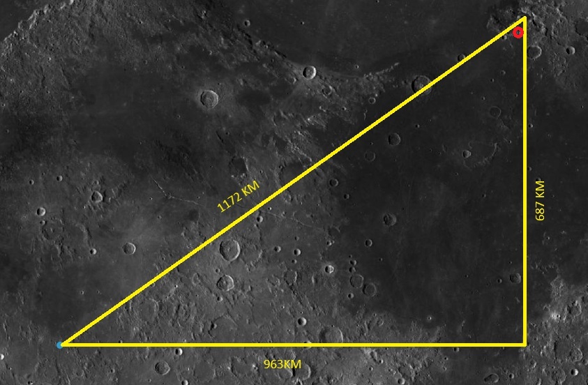
It’s very simple. The azimuth value is the bearing, from north, towards the sub-
“Derive the observer→Earth vector from the sub-
This handy site explains the relationship between sines, cosines and tangents.
It doesn’t matter which coordinate system you use to describe where the points are, the distances will always be the same. It’s important to note here that I’m using stray’s figures for the sub-
We’re trying to find the angle for the where the red circle is, so using the ballpark measurements above, the sine is 963/1172 = 0.8217. The cosine is 687/1172 = 0.5862, and the tangent is 963/687 = 1.402. If you look at the angles those sin, cos and tan values generate we get 55.3, 54.1 and 54.5 respectively.
Add 180 degrees to those so we get a bearing from north and we get 235, 234.1, 234.5 degrees respectively. Allowing for my poor measuring skills, rounding errors and it being on a sphere, and without using any actual coordinates at, all we get an angle that matches JPLs azimuth output and definitely not 182 degrees. Literal schoolchild maths.
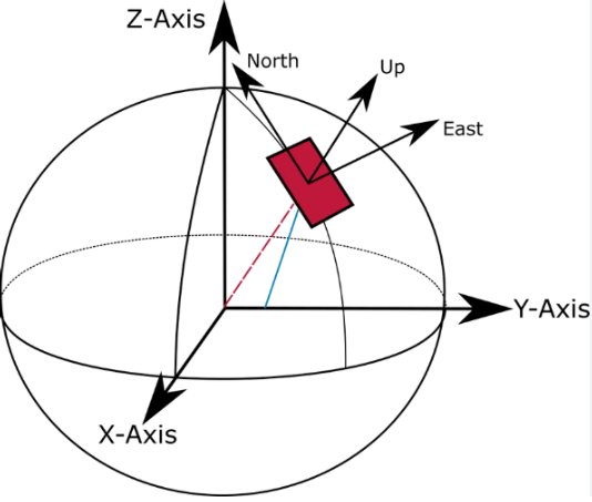
The ‘ENU’ frame of which he speaks is ‘East-
This is exactly what we already have. North is towards the lunar pole, east is parallel to the lunar equator, and up is the direction of the sky.
You can’t have an ENU system where the sub-
He continues his exposition as to how everyone and his wife is doing it incorrectly apart form him by giving an equation that we are all supposed to follow so that we can convert to an ENU frame. His argument is that
“You are substituting a great-
Again, this isn’t correct. Both points do lie on a sphere, but the line of sight direction is the bearing you need to follow to get from one point to another directly. The bearing on a great circle is not going to be the same, but not by a massive amount.
Apparently we aren’t in the ENU frame (we are):
“’Projection removes the vertical component’ is only true after you are already in the local ENU frame.. You never actually perform that transformation. Instead, you bypass it entirely and use a surface formula that has no concept of altitude or observer-
We don’t actually have to do that transformation -
“Start with Earth-
Observer: O = (x₀, y₀, z₀)
Target: T = (x₁, y₁, z₁)
Form the line-
v = T − O = (x₁ − x₀, y₁ − y₀, z₁ − z₀)“
Two things jump out there. Firstly ‘Earth centered’? This is pretty obviously something he’s copied and pasted without thinking about what it implies. The second is the ‘z’ coordinate. Look at the diagram above. If he’s got a ‘z’ coordinate he’s calculating the relationship between two objects using coordinates from the centre of the observing body. He always claimed this was the wrong thing to do. Next we have:
“Compute observer latitude and longitude
λ = atan2(y₀, x₀)
φ = atan2(z₀, √(x₀² + y₀²))
Construct local ENU basis
ê = (−sinλ, cosλ, 0)
n̂ = (−sinφ cosλ, −sinφ sinλ, cosφ)
û = (cosφ cosλ, cosφ sinλ, sinφ)
Project into ENU
E = v · ê
N = v · n̂
U = v · u”
We don’t need to convert them. We already have them. He’s taking xyz coordinates based on the centre of the moon, and then changing them into surface coordinates. We already have this. There’s no need to do it again. The next instruction is:
“Compute azimuth
az = atan2(E, N)
az = (deg(az) + 360) mod 360”
Which apparently then gives us his magic number of 172.6 degrees. As Cleric points out, at no point does he actually substitute numbers in there, as he has required everyone else to do, so that we can see how that the outcome he claims is correct has been derived. So when he says:
“Notice what your method never does.. It never constructs the observer-
If you believe your approach is equivalent, then demonstrate how your spherical formula reproduces the ENU projection from a general 3D vector, not just a surface point.. That’s the step you’re currently skipping.”
It’s just more hypocrisy. The numbers JPL Horizons generates have already taken into account those calculations. It is producing exactly what he claims it isn’t. We don’t need to do them. What he’s also ignoring is that he isn’t producing a vector to Earth. He’s producing an azimuth along the surface. It’s two dimensional, not the three he thinks it is. You still need to elevation angle in order to locate am object precisely. The azimuth/elevation numbers are a line of sight vector. Azimuth on its own won’t get you to Earth, elevation on its own won’t either. It’s how the location of objects relative to an observer in 3D space is described.
Prove us wrong stray. Put the numbers in. Show us how it’s done.
No sooner said, or is it? Apparently asking for the numbers I s”moving the goalposts (pretty much not, it’s something we’ve been asking for all along!), But he has provided a worked example.
Or has he?
He very carefully skips over the first part of the equation and goes straight to this:
“Let the observer (lunar surface) and Earth position give the line-
v = (vx, vy, vz)”
Which doesn’t match what he defined ‘v’ as earlier, but whatever
“From the observer position:
λ = −23.4°
φ = 20.2°”
Wait -
Any other calculation from there is not correct. We then get given
“Project the vector:
E = v · ê
N = v · n̂
Using the actual vector components from Horizons, this yields:
E ≈ 0.142
N ≈ −0.466”
Which vector components would those be? You haven’t given us any of the values in there, so how can we verify of the E & N figures are correct?
The final bit of his smoke and mirrors is
“Azimuth:
az = atan2(E, N)
az ≈ atan2(0.142, −0.466) ≈ 172.6°”
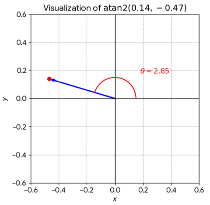
Which is kind of weird, because if I put that atan2 formula with those numbers into calculator, it comes out a 163.5°, and in the 2nd quadrant.
We asked you to show your working, not show a bit of it. All of it. Like you demanded everyone else do. The initial formula you presented is one intended to calculate a line of sight vector from the LM to the sub-
Once he’s had that coordinate error pointed out to him, he tries to shift the blame and make it look like it wasn’t his fuck up.
“So, to clear up your earlier confusion, the longitude here is +30.7717°, not −23.4°.. You were arguing against a different set of coordinates.”
Nope, it wasn’t our confusion stray, they were the numbers you posted. We are arguing against coordinates you provided. Cleric didn’t even argue with you, he asked you to explain what that longitude value represented before he discussed anything else.
Next we have some of the most dishonest maths you’re ever likely to see. He supplies the correct coordinates:
“If you convert this direction into a local ENU unit vector....
E = cos(el)·sin(az) ≈ 0.080
N = cos(el)·cos(az) ≈ −0.618
U = sin(el) ≈ 0.782
Now recompute azimuth...
atan2(E, N) = atan2(0.080, −0.618) ≈ 172.6°”
It really isn’t at all surprising that the numbers you’ve input there resolve to the values your imaginary Horizons output gave you, because those are the numbers you gave it.
To demonstrate, let’s repeat the process with the numbers the rest of the world gets, and azimuth of 238.76 and an elevation of 44.842 (calculated earlier):
E = cos(el)·sin(az) ≈ -
N = cos(el)·cos(az) ≈ -
U = sin(el) ≈ 0.0123069
atan2(-
See? See how we can all work backwards and get the same result we started with? So when he says
“So in this case, the ENU projection and the azimuth are fully consistent.”
Of course it is, you started off with a lie, worked backwards, then ended up with the same lie again.
“The earlier values (E ≈ 0.142, N ≈ −0.466) clearly do not correspond to this dataset, which is why they produced ~163°... That was a mismatch of intermediate values, not a failure of the method.”
It was your method and your numbers. They weren’t intermediate values, they were the final result.
Naturally, when challenged on this he doubles down:
“The λ = −23.4° value you are referring to was part of an earlier illustrative example, not the Horizons-
You need to go back and read your copypasta doggy, you quite clearly and very definitely used values in an “intermediate calculation” to generate your magical 172.6 number, even though the numbers in your “intermediate calculation” don’t actually generate that.
He then tries to claim he isn’t indulging in circular logic:
“You are mixing up two different operations...
A forward transformation from a physical state vector (from Horizons) into a local ENU frame, followed by computing azimuth via atan2(E, N).”
Nope, we’re watching you use a number you plucked from your arse, applied a calculation, then reversed it to get the number you started with.
“The Horizons-
The Horizons-
“Your “circularity” claim assumes that an azimuth value was inserted at the start.. That is incorrect.. The input to the process is a 3D position vector (from Horizons), not an azimuth.”
Uh-
“As for your request to “show each stage with numbers”, that is not possible from the information you are providing.”
Then how are you so confident that you’ve provided a correct answer? If it isn’t possible why do you keep demanding people do that? We’ve actually provided lots of information. You haven’t. If the calculations aren’t possible with the level of information, how are you doing them?
“The intermediate steps require the actual Cartesian state vectors (x₀, y₀, z₀ and x₁, y₁, z₁)... Without those, you cannot reproduce the ENU projection numerically in full form.”
So you’re somehow managing to generate these vectors with only half the values? You could always, oh I dunno, generate Cartesian state vectors of the landing site and sub-
“If you want to challenge the result, you need to work from the same inputs (the Horizons state vectors), not from a reduced azimuth/elevation pair or from an earlier illustrative example that is not part of the calculation in question.”
Erm..that’s what you did above. You started with an azimuth elevation pair and generated ENU values. The result you’re getting is being challenged precisely because you haven’t provided any inputs or calculation steps. Do that. Why not ask AI to do it, like I did by just typing the following into Google:
if the observer coordinates are 20.1908, 30.7717 and the target coordinates are "-
Those -
Here’s what Google’s AI did:
Would you look at that!
Notice that angle of -
We’re still waiting for you to point out where you think the south massif is, by the way. All this is just another pointless distraction from your inability to read a fucking map.
While we wait, he continues to show how tenuous a grip on reality he has. On the face of it, this seems like progress:
“your 238° result is the surface bearing from the LM site to the sub-
Hurrah! Oh frabjous day, calloo, callay! But wait…
“The Horizons value (~172.6°) is the azimuth of the actual line-
Sigh. No. Just fucking no. That 172.6 value is a line of sight vector along the surface. That’s why all your horizons outputs have an accompanying (and also incorrect) elevation value. You look along the ground in a direction, you look up in another.
“If you want to show equivalence, you would need to demonstrate that a great-
“If you want to show equivalence, you would need to demonstrate that a great-
Sauce for the goose doggy. You have yet to demonstrate your numbers point at Earth. We have, using Stellarium, the LRO, every variant of JPL Horizons output imaginable. All you need to do is prove where you think the south massif is on a map.
Well boys & girls we had a couple of days off. Maybe stray was rethinking his life choices, maybe he was going outside for the first time, who knows. Whatever he did, it wasn’t fact checking or doing any actual calculations. His line of argument is now:
“You computed.…
v = T − O
which is the vector between two points on the Moon’s surface.
That gives the direction to travel across the Moon to reach the sub-
That’s correct -
As part of his claim he says
“Show that (T − O) is parallel to (Earth − LM)”
Well, we did that numerous times many moons ago. It’s been demonstrated in all manner of ways, but just as a reminder, here it is in Stellarium.
Azimuth/elevation values are a form of line of sight vector. They describe in 3D space which direction you need to look in order to locate a specific point. One direction in the horizontal plane, another in the vertical. Your own azimuth elevation values are no different, except that they’re wrong. This:
“On a sphere, the direction along the surface (great-
Isn’t true, at least, not in the way you want it to be. Great circle bearings to a chosen destination change as you go along the great circle. At high latitudes and long distances, when travelling east to west, on Earth, then yes, you can have a large deviation. On the moon, where the distance between the two points we’re looking at is 1000 km and much closer to the equator, not so much. Here;s the thing though: the azimuth between the start and end points is still the same. The bearing you travel along a chosen route might vary, but the bearing between start and end is the same regardless of how you get there. I could head East over Russia and China to get to New York from my house, but the actual azimuth is still west.
This comment:
“Changing reference frames (ME vs IAU_MOON) does not change what is seen...It only changes the numerical description of it.”
Is absolutely correct if only you could see it. It doesn’t matter how you describe the direction of Earth, it will always be hanging about the South Massif. Your problem is that none of your calculations point in that direction. They are not consistent either within the model you think works or with any models that actually work.
This:
“Until you compute the actual line-
Is what you actually need to do, because you haven’t yet. Everyone else has. You haven’t. Off you go doggy. Fetch.
Has he fetched? Has he come up with real numbers? Has he bollocks, but he has procured some of the finest calorie free word salad you’re ever likely to waste your eye muscles on. He still can’t get his tiny mind around the fact that the latitude and longitude figures on Earth are rotating, and just can’t grasp that the fact that the figures for his Earth show it not rotating are an indication that his numbers are as wrong as his comprehension. This is where it gets really stupid. Apparently when it comes to the wildly different azimuth values…
“The discrepancy comes from different azimuth and reference frame conventions”
Erm…ok…
“In a standard lunar local ENU frame (az = atan2(E, N), clockwise from true North), the result is ~238.8°.. That is the geodetically consistent azimuth under that convention.”
Awesome. We’re all on the same page, the Earth is at an azimuth of 238 degrees, we can all get on with our lives now. Or can we?
“The ~172.6° value arises when the same direction is expressed in a different local reference frame where the horizontal axes are rotated relative to true lunar ENU (e.g. terrain-
az_local = az_ENU − 66.2° ≈ 238.8° − 66.2° = 172.6°”
Wait, what? So we’re physically rotating the landscape now? Somehow his value is because the camera direction is being incorporated into his JPL calculations? Again, he’s simply taking a value, subtracting another value, then adding it back again and treating it as some sort of proof of his argument. At no point anywhere is he attempting to tell us how this “frame offset” is being added, or why.
“So, both values refer to the same physical Earth direction, but in DIFFERENT COORDINATE SYSTEMS!! .. The discrepancy is not evidence of incorrect or dishonest ephemeris data, but of a mismatch in azimuth conventions and reference frame definitions.”
EXCEPT THEY FUCKING AREN’T!! If they are different coordinate systems, why not identify which one is being used that’s different to every single coordinate system out there that has Earth at 238 degrees form the lunar module at Taurus-
“If we want a meaningful comparison, the azimuth convention and frame definition must be explicitly fixed before quoting a single “correct” number.”
Go ahead doggy. Still waiting for you to fetch. It’s been pointed out to you on numerous occasions what conventions and frame definitions are being used to generate the 238 degree azimuth. Let’s see what yours are that are producing 172.6, see if you can make your calculations work the way Cleric has produced the actual numbers and produced correct answers -
Apparently, though, we’re all correct! Look, see!
“The ENU result (~238.8° / 44°) is derived from the geometric state vector projected into a local tangent frame.”
Yay! Remember how he told us that this is what we needed to do to get the values to read 172 degrees?
“The observer-
Erm…no, I was under the impression that we needed to apply an ENU projection, now we don’t? Which is it stray? You specifically said we needed to convert it into a local ENU vector, now we don’t. You have spouted so much bullshit you’ve forgotten what straws you’re clutching at.
“So the discrepancy…comes from comparing a geometric vector-
No, it doesn’t. Your initial starting point for all this nonsense was that your figure of 172 degrees was produced by JPL horizons,, and was correct because it was topocentric, and we were all calculating it from the wrong place. Now you’re arguing that the topocentric value is different to the one you’re calculating, but you still haven’t managed to produce any calculations to demonstrate how this magical transformation is being applied. Despite claiming in another comment that
“The discrepancy comes from different azimuth and reference frame conventions, not from altered or invalid data.”
You have not once identified the reference frame conventions that show where that discrepancy comes from. Not once. You have done no maths. You have not shown us how this transformation is occurring. You have offered nothing but trust my AI bro, so this:
“If you want to resolve this, the step that’s still missing is this.. Explicitly define the azimuth convention and local frame used in each calculation.”
Is just more hypocrisy. Cleric has specifically defined everything. You have defined nothing. Show your working. Point us to where you think the South Massif is on a map.
You’re also still flapping about like a fish out of water when looking at the Obs subLong values. You don’t seem top understand that this:
“If ObsSub-
That does not happen.”
Is completely wrong. It is exactly what happens. Earth rotates in the lunar sky above the observer. Different longitudes are in the centre line of the Earth every minute of every day. Once you grasp this simple fact, you’ll realise it’s why your 172 degree values can’t be taken seriously.
“You’re mixing up two separate things...
Rotation of Earth (features moving across the disk)
Direction of the Earth–Moon line (defines sub-
You’re treating them as the same.. They are not.”
They are not being treated as the same thing, but one of them determines the exact point on Earth of the other at a specific time.
“Bottom line ....
ObsSub-
The bottom line is that you’re fucking clueless and way out of your depth. You’re so invested in the lie you’ve latched on to about Apollo you’re incapable of listening to reason.
I’ve had a few days off from this because it’s getting very repetitive, tedious, and frankly I’ve had better things to do.
The state of play so far is this:
Straydog has essentially admitted that we were right along. When measured from the LM, the Earth is at an azimuth of around 238 degrees and an elevation of around 44. Just as we said along. Just as the LRO quickmap says. Just as Stellarium says. Just as a simple protractor says. Just like Pythagoras says. Just like every permutation of JPL Horizons says. Just like manual calculation of ENU vectors says. Just like the mission planners at Apollo said. Just, in fact, like everyone says, except one model that straydog has never once been able to reproduce. The Earth was never east of south of the LM. It’s physically impossible to be that.
Seemingly blind to the calculations everyone has done, he is still insisting people do calculations, but seems incapable of doing the calculations himself. These, stray, are your words:
“Calling a result “DECEPTION” without ever doing the calculation in the frame it comes from isn’t a refutation, it’s an admission you haven’t done the work.”
Calling your results correct without ever doing the calculations isn’t proof of anything. It’s admitting you haven’t done the work. Insisting that IAU_MOON is a Principal Axis reference frame, when it isn’t, and insisting that there should be minimal change in the coordinates directly above the observer on Earth is proof that you do no understand a single fucking word of anything you have copied and pasted.
As always you were wrong again. We’re done.
Or are we?
Just when you think he can’t sink any lower or post anything even more stupid he surpasses himself.
Firstly, he reposts a long series of imaginary calculations that he insists prove that his ‘172 degrees’ figure is correct and looking south after all:
“A representative normalized vector is:
E ≈ +0.14
N ≈ −0.47
U ≈ +0.88
Which yields: azimuth = atan2(E, N) ≈ 172.6°”
Notice he’s being very specific here, stating that those values definitely produce his magic 175.6 degrees figure. Just one teensy weensy problem: it doesn’t.
Atan2(0.14, -
Now what happens if you make it atan(-
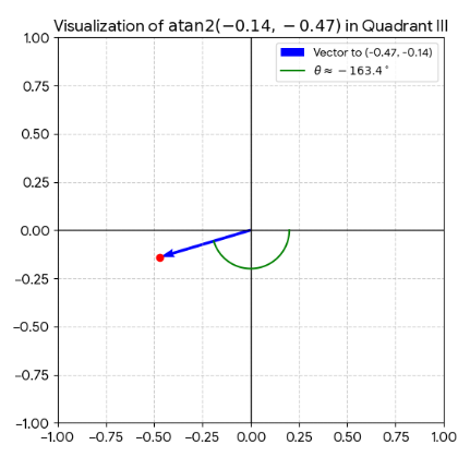
You get -
He follows all that up with some more AI generated bullshit, claiming that what we all now need to be doing is using IAU_MOON because it references the Earth-
“For Apollo 17 EVA planning, you need the actual, precise position of the barycenter at the exact time of observation, which MEAN_ME cannot provide”
Now remember, Apollo 17’s EVA planners produced figures that match modern calculations to within a fraction of a degree, but there’s also this simple fact: you can choose the Earth-
So despite him claiming that Mean_ME doesn’t can’t use it, there it is, right there in the JPL Horizons values. Can we guess what azimuth elevations values for it produces?
The barycentre is inside Earth. Anything wanting to know the direction of the barycentre is going to be looking in the direction of Earth. Idiot.
The back and forth is continuing over this between stray and Cleric. Stray is demanding that everyone produces the figures that they have already produced, while he produces no figures at all, and handwaves away the problem of his atan2 values being 9 degrees out as some sort of rounding error, which is bullshit, and that the difference between his 172 degrees value and everyone else’s value of around 238 is because of the IAU_MOON and MOON_ME coordinate systems.
What he is absolutely failing to register is that the elevation and azimuth values are describing the relationship between two objects on the lunar surface: the point directly under the Earth and the location of the lunar module. It does not matter who you describe the location of each individual point, the relationship between the two of them will always be the same. I’ve demonstrated this very simply many times. You could make zero longitude and latitude sit on top the LM, the azimuth value to the sub-
The only way his figure of 172 degrees is possible is if he is using a system that calculates the azimuth along the x axis, or East, not north. Until he demonstrates his calculations to prove otherwise that’s what I’m assuming his AI has done, because it certainly wasn’t him that did anything. The sub-