4.6.8 - Apollo 14 - back in orbit
In addition to these colour images of Earth from lunar orbit, there is a black & white series of an Earthrise that must also have been taken before leaving orbit on the 7th at the latest. AS14-71-9847 (figure 4.6.8.1) is the second in a short series of exposures near the start of the magazine. Immediately after them are photos of craters strongly suggestive of increasing orbital altitude. Photographs looking vertically towards the lunar surface are over 200km wide, compared with around 10% of that width for images taken in orbit. We therefore seem to have a view of the moon taken after the TEI burn as the round the far side for the last time.
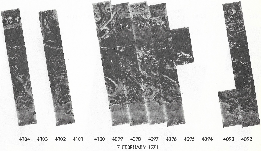
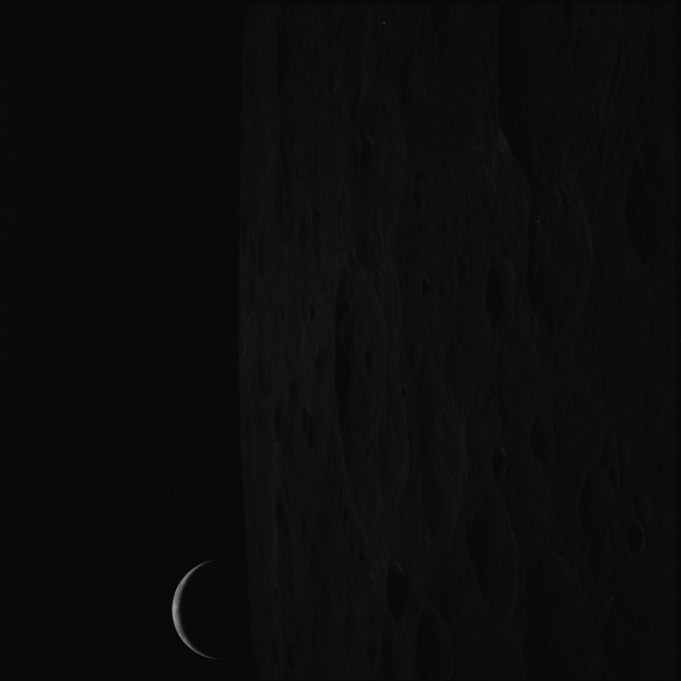
Figure 4.6.8.1: AS14-71-9847 (Source: AIA)
The width of the crescent in the photograph is roughly the same as that in the Earthrise examined from the previous day, which confirms that it was also taken around the same time and not earlier in the mission. There are, however, no visible landmass features to allow us to work out where the image is, so we are reliant on weather features as a guide as to where the terminator is falling. The photographic index lists it as being taken in Trans-Earth Coast, and we also have this in the transcript:
149:28:42 Shepard: You bet. We're making like tourists with the cameras right now.
Which ties in with the series of photographs of an obviously receding moon. We know that they emerged from behind the moon at around 02:00 on the 7th, so we can at least look at what should be visible at that point, so let’s see how we do in figure 4.6.8.2.
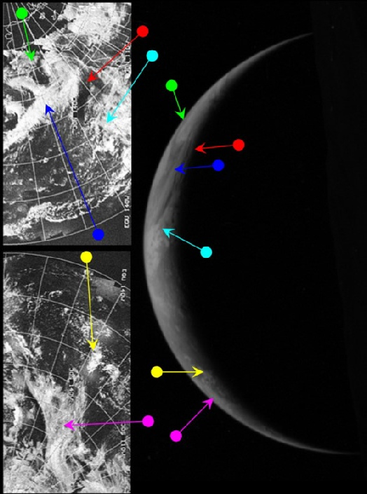
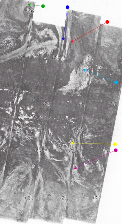
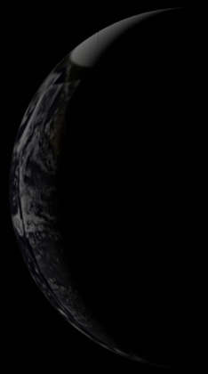
The most obvious feature is the large apostrophe shaped weather system in the northern hemisphere, which should at least be easy to find. The bulk of the tropical region seems to be cloud free, before scattered sub-tropical clouds appear in the southern hemisphere. Some other systems are just visible in the southern temperate region that may be visible in satellite images.
In analysing this image, we need to use the same technique as the previous image and use those days where there data do exist to cover for days where it is absent. It should be obvious from the previous analysis that the photograph must be later than the 5th, and appears to show a crescent consistent with the 6th of February rather than the 7th. Examination of NIMBUS images from the 6th show that there is are systems resembling those in Apollo photograph in the northern Pacific, as well as the open equatorial oceans and scattered sub-tropical clouds in the southern hemisphere suggested in the Apollo image. The northern Pacific parts of ESSA images from 8th are included to ensure complete coverage, while southern hemisphere ESSA images from the 7th. The NIMBUS image shows the infra-red Nimbus image from the 7th as this gives better coverage.
Those readers who have actually been bothering to look at the analyses presented previously will probably have looked at the preceding figure and not quite understood the arrows drawn on the ESSA side of things. Arrows have been drawn, but the weather systems they are pointing at bear only slight resemblances to the Apollo image. The NIMBUS side of the figure is much more obvious – the apostrophe shaped system is very evident in the NIMBUS visible spectrum image, as are the thin band of cloud to the east of it and the scattered clouds to the south of it. This suggests very strongly that we have the date correct for the Apollo image. The track covering this cloud system is number 4097, which was commenced at 10:51 on the 7th.
Again, despite missing key elements of the data, logical deduction allows us to make reasonable assertions using the data that are available. We have a photograph taken at Earthrise followed by other images indicating the Moon falling away from the Apollo craft, a crew stating that they are taking photographs, and a weather system photographed at around the same time that doesn't match the same area the day before or two days later. It’s also worth mentioning that the 3D reconstruction again bears out the analysis.
The last full image of Earth takes place on the next day, so click the link to see it.
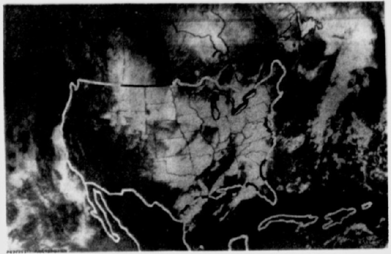
Figure 4.6.8.1: AS14-71-9847 compared with ESSA imagery from February 7th (bottom left) and 8th (top left), NIMBUS Infra Red from the 7th ( top centre), a 3D reconstruction (top right), SkySafari terminator depiction (left) and Saratosa Herald Tribune ESSA image from the 7th (above).