4.2.3 Apollo 10 Images – Day 3: May 20th
Magazine 34’s next shot of Earth is of Africa, so clearly some time elapses before it is used again. Meanwhile magazine 35 takes over, and the next shot is of AS10-
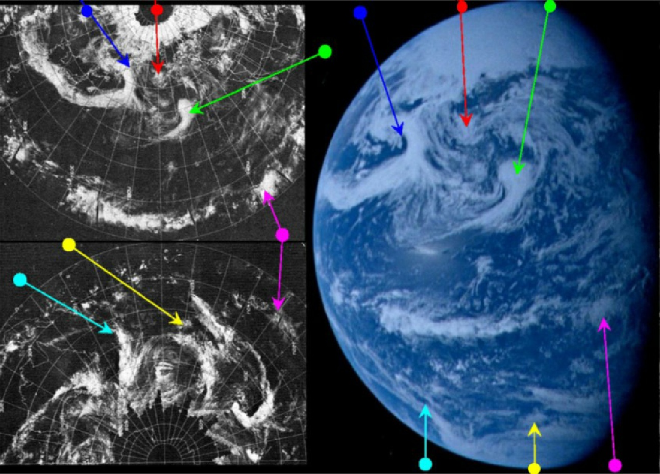
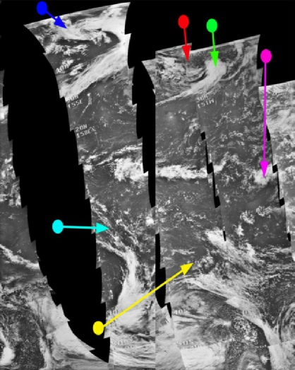
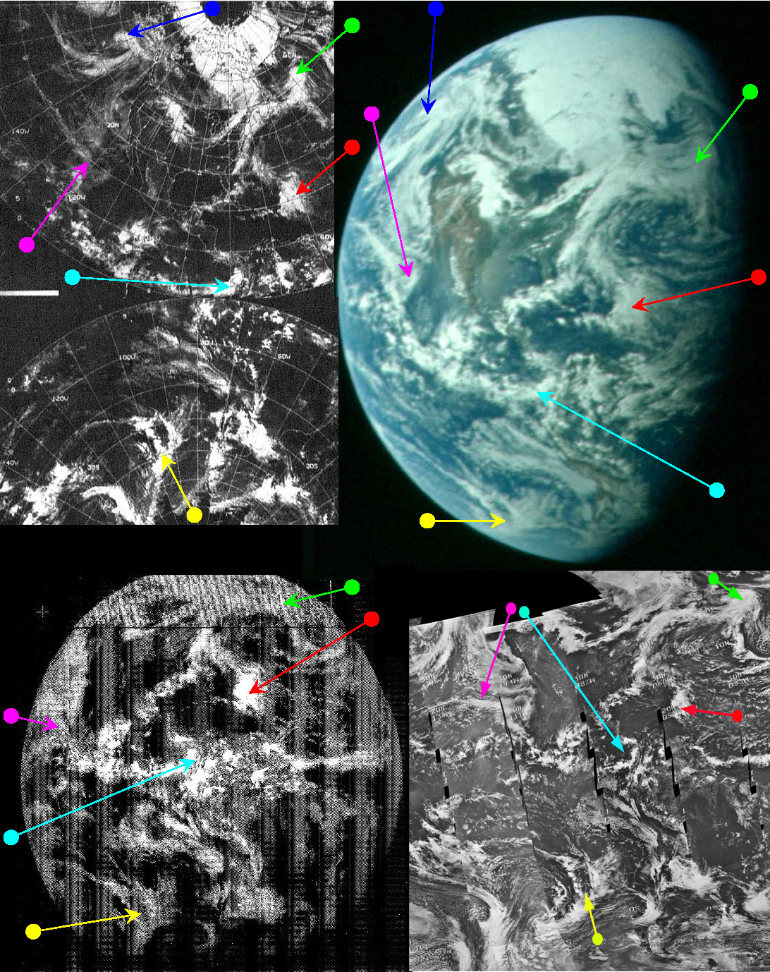
Figure 4.2.3.1: AS10-
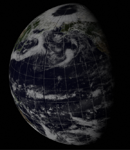
Figure 4.2.3.3: ESSA 9 (left upper and lower) and NIMBUS 3 (centre left) images compared with AS10-
SkySafari sets the time at roughly 01:45 for this image, and shows the west coast of north America and Australia just in view. Close examination of the Earth shows that, beneath the thin cloud, the Americas are still there. Australia is more difficult to detect, but the bifurcated thin stream of cloud shown by the cyan arrow is off Australia's east coast at the point where it splits, and what appears to be a small fog bank off Sydney on the satellite photograph is just discernible on the very western edge of the globe.
The Earth, therefore, seems to be where it is supposed to be – a few hours ago the crew were describing north America and now it is only partially visible. Can the satellite timings match up with this suggestion? ATS is not available for this image as it doesn't cover anywhere visible. ESSA's image is still dated the 19th, but is now covering areas that were actually imaged on the 20th, and in this case the orbit that best approximates the line of the terminator is number 1032 (track 5, although in reality the terminator is probably between tracks 4 and 5), which commenced at 23:06.
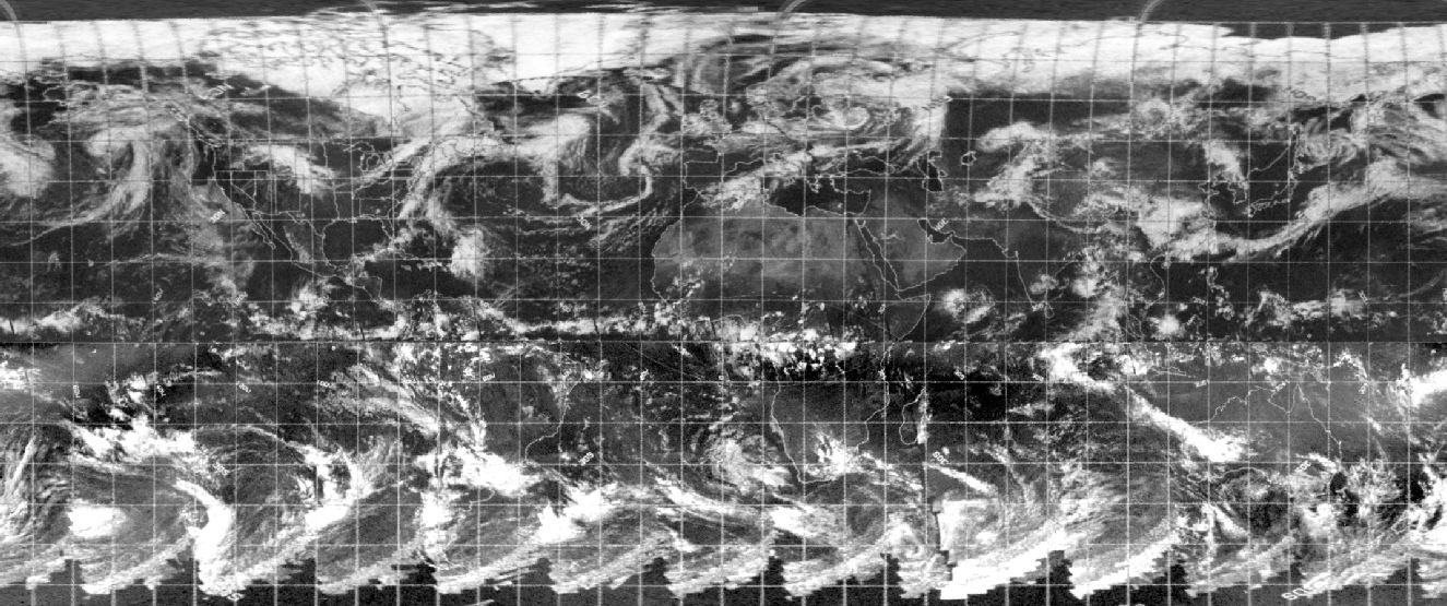
The NIMBUS image used here is actually a hybrid of two day's passes. The 2 strips of images on the left of the NIMBUS part of figure 4.2.1.24 are actually from the image dated the 20th, and the remainder are from the image dated the 19th. The track best representing the terminator is number 475, which was commenced at 17:26 on the 19th. The extra amount of rotation brings an additional pass of the NIMBUS infra-
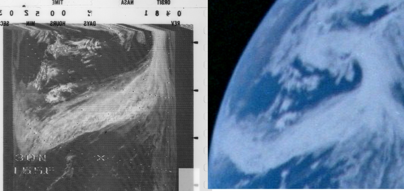
Figure 4.2.3.4: Section of NIMBUS infra-
Again, the correspondence between the two is excellent -
After this image of the Pacific is taken there is a gap in photographs of any kind coinciding with a rest period for the crew. At 1d19h50m the crew are having breakfast and being given a summary of news from home, and they describe the view below:
043:49:32 Cernan: Jack, here comes the world. Looking right over Suez Canal, Saudi Arabia, the Mediterranean, Africa, back into the parts of Europe…right now I'm looking at all of Africa, which is almost totally clear with the exception of a few clouds on the western side. I can see across the Straits of Gibraltar, some cloud cover just on the eastern side of the Straits. I can see Spain which is totally clear, Portugal, almost all of the Mediterranean except the north -
The time of this conversation translates to 12:50 GMT on the 20th, and there are two photographs taken on separate magazines that correspond with this time both in terms of where the terminator is, and in terms of what is visible below them.
AS10-
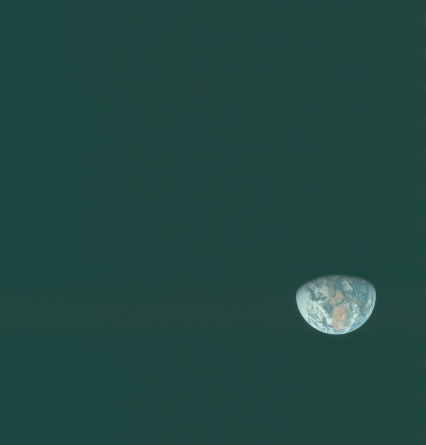
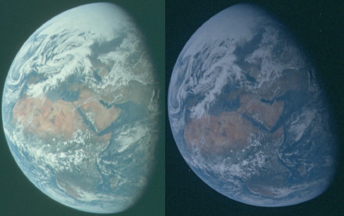

Figure 4.2.3.5: AS10-
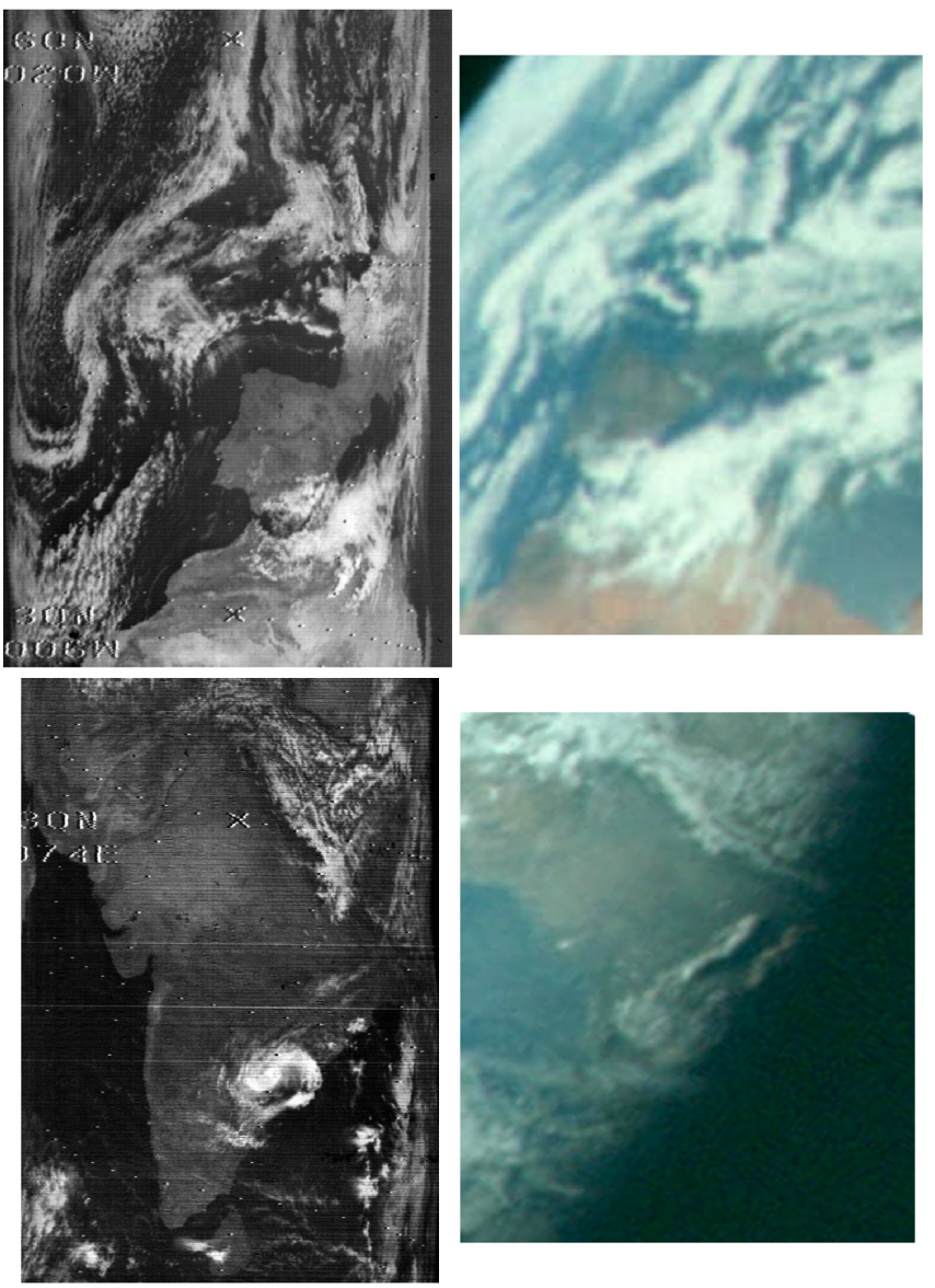
The extreme close up of India suggests that AS10-
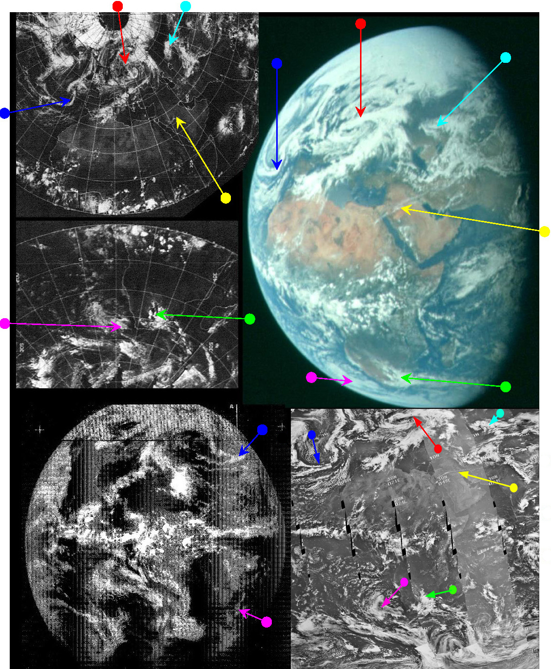
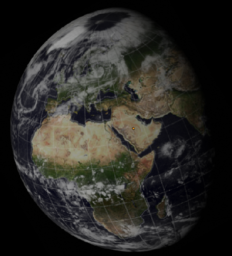

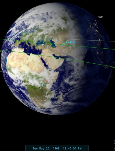
Figure 4.2.3.6: ESSA 9 (top left upper and lower), ATS-
The most obvious point to make about the image is that it shows exactly what the astronaut was describing. The ATS image only just shows the very western edge of what they can see, and certainly doesn't show any of Europe or Arabia. At the time the photograph was taken it would be several hours before those features would be visible on satellite mosaics. We can determine this by looking at the timings of the satellites concerned.
The ATS image shown here is taken just after 17:00 on the 20th. The ESSA image is complicated by the fact that the terminator line falls roughly along the line delineated by the last orbital pass on the image dated the 19th. The ESSA mosaic states that the last pass on that image is number 1037 (track 10), which commenced at 09:03. Track 11 (orbit 1038) passes along the west coast of India and is the first scan on the image dated the 20th, commencing at 11:08. While this is a good 90 minutes before the Apollo image was taken, the final part of the ESSA image covering what is visible in the Apollo photograph would not be imaged for another 5 hours.
The NIMBUS image is more straightforward, and the line of the terminator was covered by pass number 482 at 05:39 on the 20th, but again the final part of the area visible from Apollo wouldn't be completely imaged until around noon when the daylight pass of orbit number 485 finished. It’s worth pointing out in terms of the 3D reconstructions that the data to the east of Africa on the ESSA image is dated almost 24 hours after the pass over Africa itself, whereas the NIMBUS swathes are from the same day, hence the closer match on the NIMBUS image with what we see in the Apollo one.
Speaking of NIMBUS, figure 4.2.3.7 shows the infra-
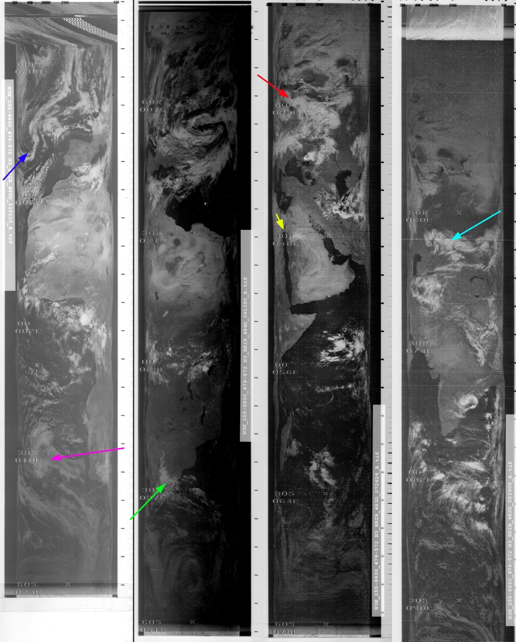
Figure 4.2.3.7: NMBUS-
As usual there is an exact match between the NIMBUS and Apollo image, but the real devil is in the details (figure 4.2.3.8).
Figure 4.2.3.8: AS10-
The top section of this image is included mostly for comparison with an earlier image (4.2.2.5), which is obviously different. The Apollo image is again an almost exact match. The lower is is included to show the presence of a tropical cyclone. A number of reports (eg this one) tell of an unnamed cyclone in the Andhra Pradesh region on the 19th, killing over 600 people. Andhra Pradesh is pretty much exactly where this cyclone is pictured and can also be identified in the Apollo image.
About an hour after the image discussed above, Apollo 10 took another set of images of Africa up to AS10-
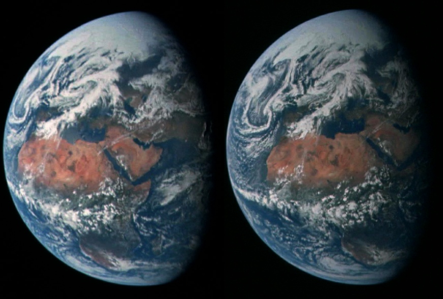
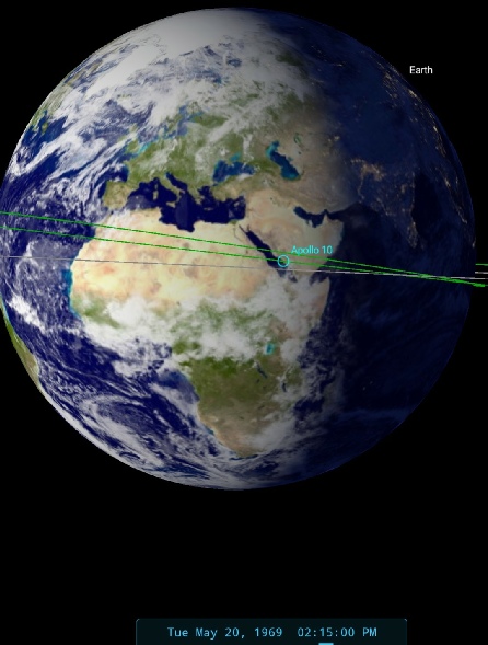
Figure 4.2.3.9: AS10-
The next photographic image to be scrutinised is another case where the same photograph exists on two different magazines. AS10-
SkySafari puts the time at the terminator at around 17:30 GMT, and an hour before that in the transcript the crew describe being able to see the Suez Canal. This is clearly not in shot in the Apollo pictures, so they must have been taken after that time. They are able to describe
047:26:30 Cernan: Charlie, the Suez Canal appears now to be going into darkness. We're looking at most all of Africa, the Mediterranean Sea, Spain, Portugal are in view. So the folks down in that part of the area ought to be getting a good picture of themselves right now.
047:27:12 Cernan: Well, it's a beautiful sight. All of Africa is brown again, of course, and the waters are very, very blue.
047:31:18 Young: …you can see, for, example, the Pyrenees. And you can see there, -
and when asked about the islands around Greece and Italy they say that
047:32:08 Young: They're pretty close to the terminator right now, and it's a little smoggier today than it was yesterday, but yesterday Crete was very clear, l could see Cyprus; the Nile Delta is very clear right now. You can see the Nile; the Nile Valley really stands out, and, of course, the Sahara Desert is very clear, you can see geological features in the desert. It looks like Lake Chad down there in the middle of the – middle of Africa.
Again, the middle of Africa and the Nile are not visible in the image, although Greece and Italy are not quite at the terminator at the time they are speaking.
An hour after the SkySafari estimate they discuss the weather situation over north America, thunderstorms over Brazil. We therefore have some distinctive weather features to look out for in the both the Apollo image, and in the satellite photographs taken on the same day.
Those same distinctive features crop up in the next view of Earth in the time sequence, as shown in a TV broadcast sent down to Madrid. The signal was then sent on to Houston to be rebroadcast later. It’s worth noting that while the mission timeline indicates the recording as being between 16:49 and 17:04, the actual broadcast in the transcript starts just over half an hour earlier.
Figure 4.2.3.10 shows a screenshot from that broadcast compared with the satellite record.
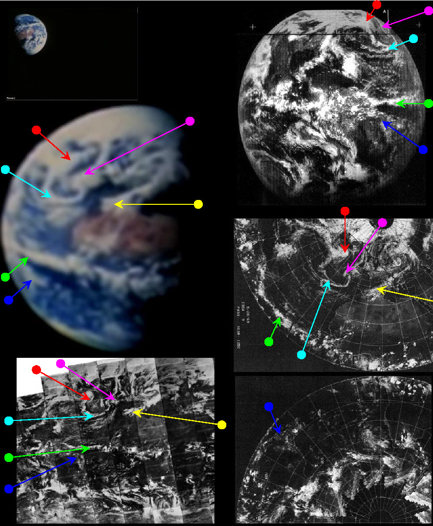
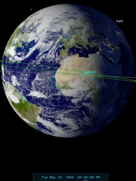
Figure 4.2.3.10: Screenshot of Apollo TV footage compared with ATS (top right), ESSA (middle and bottom right) and NIMBUS (bottom left) satellite images dated 20/05/69. Below that are ESSA (left) and NIMBUS (centre) 3D models built using digitally restored data and right the SkySafari time estimate
As usual the crew provide ample and accurate descriptions of what they are seeing below them.
047:33:12 Young: That certainly is an interesting weather -
047:34:03 Duke: Roger. That thing has been there constantly almost since, it seems like, since you guys started showing us the pictures back. Do -
047:34:26 Young: We're right -
The next image chosen for analysis is AS10-
Figure 4.2.3.11: AS10-
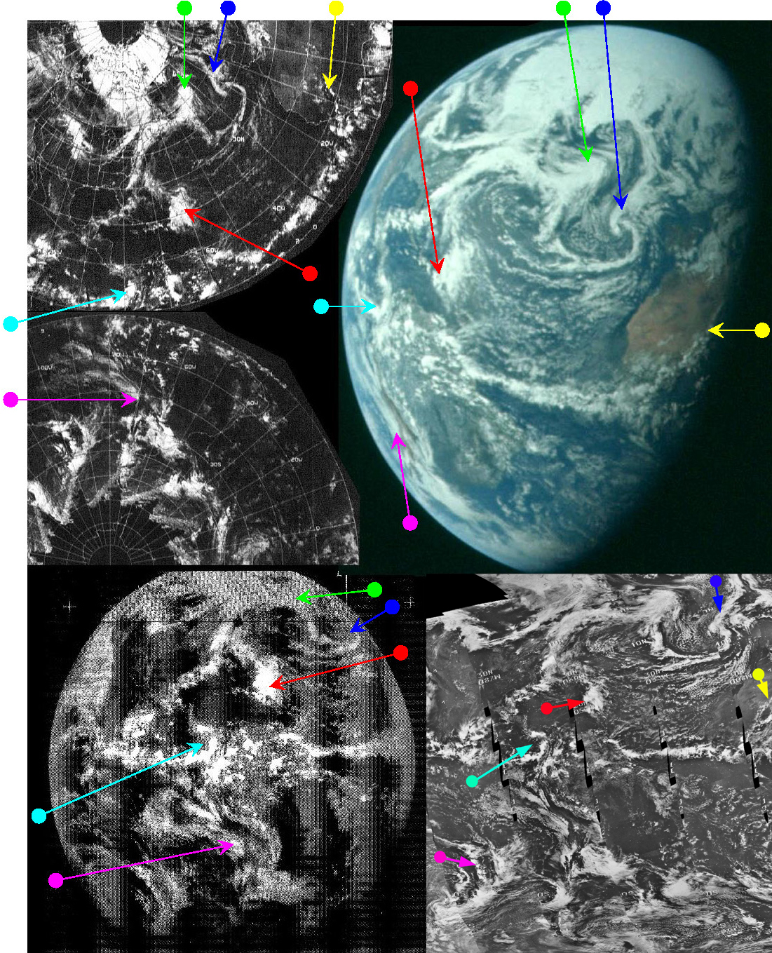
In figure 4.2.3.12, ESSA's orbital data puts the time of the satellite passing over the west coast of Africa at 14:09 on the 20th (Track 1, or pass 1040), compared with NIMBUS orbit 485 over the same zone at 11:20. ATS-
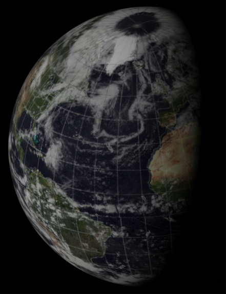
Figure 4.2.3.12: ESSA 9 (top left upper and lower), ATS-
One example is the system arrowed in yellow. In the NIMBUS image, the earliest of the three, this small group of clouds touches the west African coast and trends north-
To illustrate this point further, a small section of each image from figure 4.2.3.12 has been selected so that they can be compared more clearly – see figure 4.2.3.13.
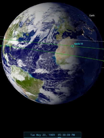
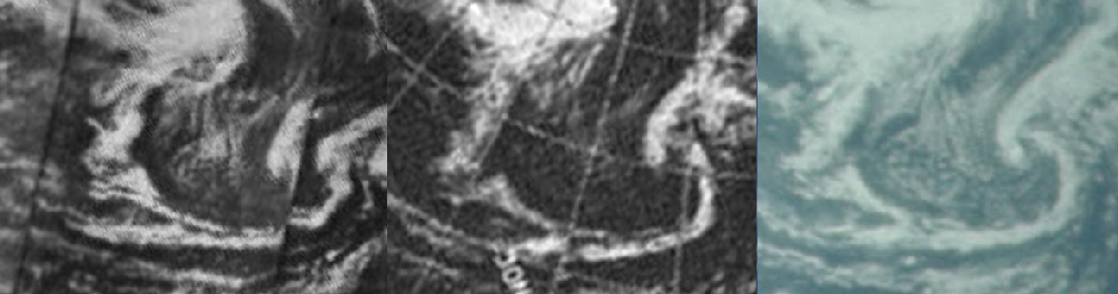
Figure 4.2.3.13: A section of ESSA 9 (middle), NIMBUS 3 (left) and AS10-
Allowances need to be made for differences in image projection and quality, but as with other comparisons it is clear that these are the same cloud systems photographed at slightly different times – the Apollo image is not a coloured version of a satellite one.
The next few photographs in magazine 34 show the same scene but taken a short while later. Figure 4.2.3.14 shows the image and SkySafari time estimate.
It should be obvious that there’s only a slight difference between 5049 and 5051, but it’s a difference nonetheless, clearly showing that we are not dealing with a single static view of Earth.
Next in the time sequence is a 16mm image and still from a short opportunistic TV broadcast. It’s shown in figure 4.2.3.15. There’s nothing to be gained from showing the same satellite images and arrows all over again, but it’s worth pointing out that the two sets of images appear to have been taken were taken a short while apart.
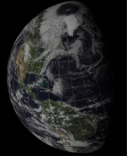
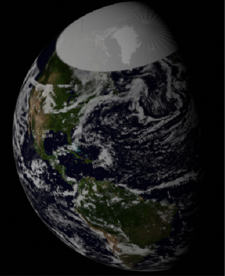
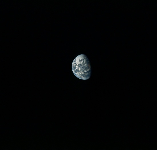
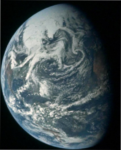

Figure 4.2.3.14: AS10-
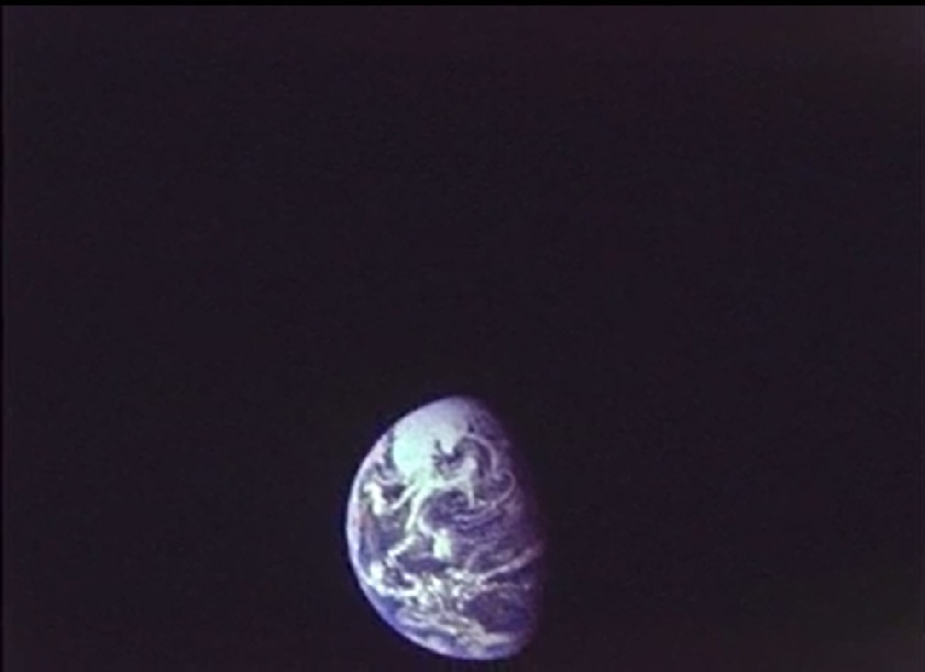
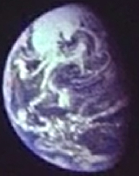
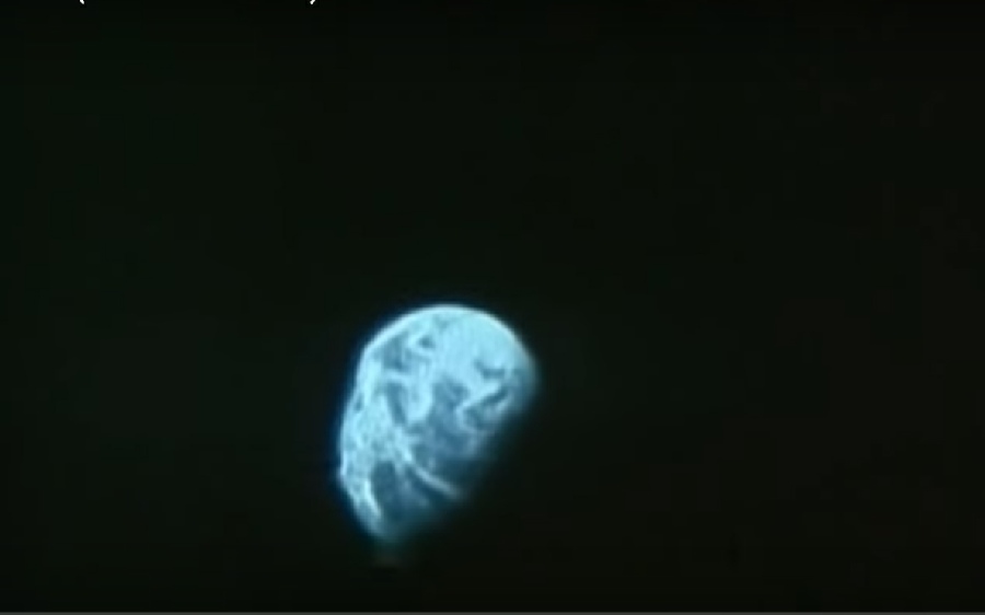
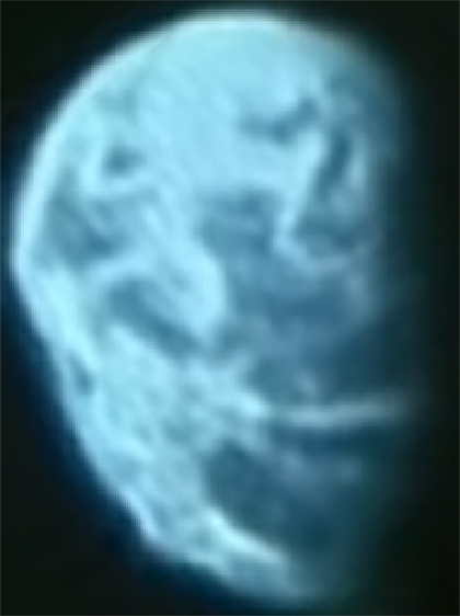
Figure 4.2.3.15: 16mm and live TV stills from Apollo 10 compared with a SkySafari time estimate and 3D reconstructions using restored ESSA (left) and NIMBUS data (right).
The distinctive cloud pattern visible in the still image has moved eastwards in the video still, and Africa has now disappeared from view. There is a distinctive curl at the top end of the south American continent where it joins central America, and by the time the video is taken this has also moved eastwards by some distance.
The basis for the timing for the terminator is from the position of the distinctive cloud patterns just above Africa, a small part of which is visible. As will become clear in the next photograph, the clouds around South America put it in the correct place for the timing in this image, and we have these exchanges during the TV broadcast.
049:30:47 Cernan: Charlie, I'm looking at the Earth now through the monocular, and I can see the west coast of Africa. I can see Spain and Gibraltar very, very well. I can see just about 90 percent of South America, up, through Central America. I can see the whole Gulf Coast all the way to California, and on this side now, Cuba is very visibly clear. All of Florida is clear. The whole Gulf Coast is clear. I can look up the East Coast maybe to about the Carolinas, and then it appears to get a little bit cloudy. And it appears that the Great Lakes, I think I can make out Lake Michigan and probably Lake Superior. And then there are some clouds up in the northwestern central United States...Coming out of the North Pole down into the Central Atlantic are some very weird, picturesque cloud formations. Swirls, not definite low areas, but big large swirls.
049:31:44 Cernan:…Coming out of the North Pole down into the Central Atlantic are some very weird, picturesque cloud formations. Swirls, not definite low areas, but big large swirls.
049:32:09 Cernan: It appears to be about the best view that I've been able to have of the whole Atlantic and South and North America from where I am, and it ought to be getting a little bit better as we go along...There are some scattered cloud coverage down in the Caribbean which may make it difficult to pick some of those islands out.
049:54:59 Stafford: Okay. I'll kind of narrate this, Charlie. I'm kind of at an odd angle to hold it out the window. Again, you can see the west coast of Africa, the Sahara Desert, they're all in orange. You can see the Atlantic Ocean with swirls of clouds over to the eastern part of Brazil. You can see the very weird cloud patterns that Gene described out over the northeastern part of the United States. Again, it looks like the North Pole and that whole area around Canada is completely socked in... Again, the one thing that is really so amazing, as you look at the Earth, is the amount of cloud cover that we have down there. Over the tropical rain forest of South America, there's just numerous small cumulus clouds.
049:55:55 Duke: Roger. Can you describe the color as contrasted to say, the Andes or the American Desert?
049:56:03 Stafford: Roger. The color of the tropical rain forest there is more of a greenish brown. It's a greenish brown versus a brown-
049:56:22 Duke: Roger. Can you pick out the Amazon River?
049:56:23 Stafford: Negative. No. I can't pick out the Amazon. I am looking at it with my naked eye where Gene had the 28-
050:04:49 Young: Roger. In about another hour and a half, you ought to be right underneath us. And, boy, it ought to be the most remarkable picture of the United States ever made. The whole North American continent is just standing out. It's really -
050:05:13 Young: You can see Puerto Rico, Haiti, Jamaica, Cuba, Florida. The Bahamas are under cloud cover right now, but, in general, the whole United States, except for the New England states and a path cutting down through the middle of the United States, Wide open. You can see the GreatLakes very well.
050:05:56 Young: Roger. Mexico and the Yucatan peninsula and even some of Central America. I can't see Panama. I can see parts of Venezuela, Colombia, and, of course, most of Brazil is wide open. Chile seems to be open along the coast down there. Peru and Bolivia are probably under scattered clouds today.
050:08:02 Cernan: Charlie, I've got it out my window now, and, like John said, it's so remarkably clear. Lake Superior and Lake Michigan stand out very brightly. There's just a patch, a little patch of clouds, on the Chicago-
050:09:18 Cernan: It's also very interesting just to watch the continents come out over the horizon as the world turns more towards us -
050:09:38 Cernan: And I agree now with John. You can see practically that whole island chain all the way down to Trini[dad].
SkySafari has been set to be at the early part of the broadcast and their descriptions match what should be visible at this point. While the 16mm footage does have suggestions of a slightly later time (the distinctive north Atlantic cloud swirl appears to be nearer the terminator), it’s difficult to tell if this is because of the different recording medium. For that reason I’ve not a separate SkySafari estimate.
The next image where any significant degree of rotation has occurred is in AS10-
Figure 4.2.3.16: AS10-
No comment is made in the mission transcript (other than the crew saying that they have a fine view of Earth at roughly the right time!), so we are reliant on SkySafari for an exact fix, based on the position of the south American coast on the Apollo image, which gives an estimate of around 20:30 on the 20th, still around 24 hours from LOI.
The time of the ATS image has already been stated as just after 17:00 on the 20th, and the rotation of the globe is such that it is now a close match with what can be seen in the Apollo image, with the exception of the system pointed out by the blue arrow, which is just out of shot. The ESSA & NIMBUS mosaics are still a good match and show all the weather systems visible on the Earth.
As far as their timings go, ESSA's most representative orbit at the terminator is track 2, which in this case is orbit 1041, commences at 16:04 on the 20th. NIMBUS' best orbit is pass number 487, which would have commenced at 14:55 on the 20th.
The infra-
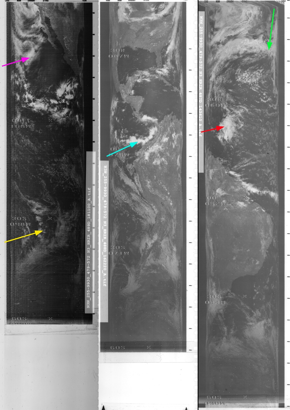
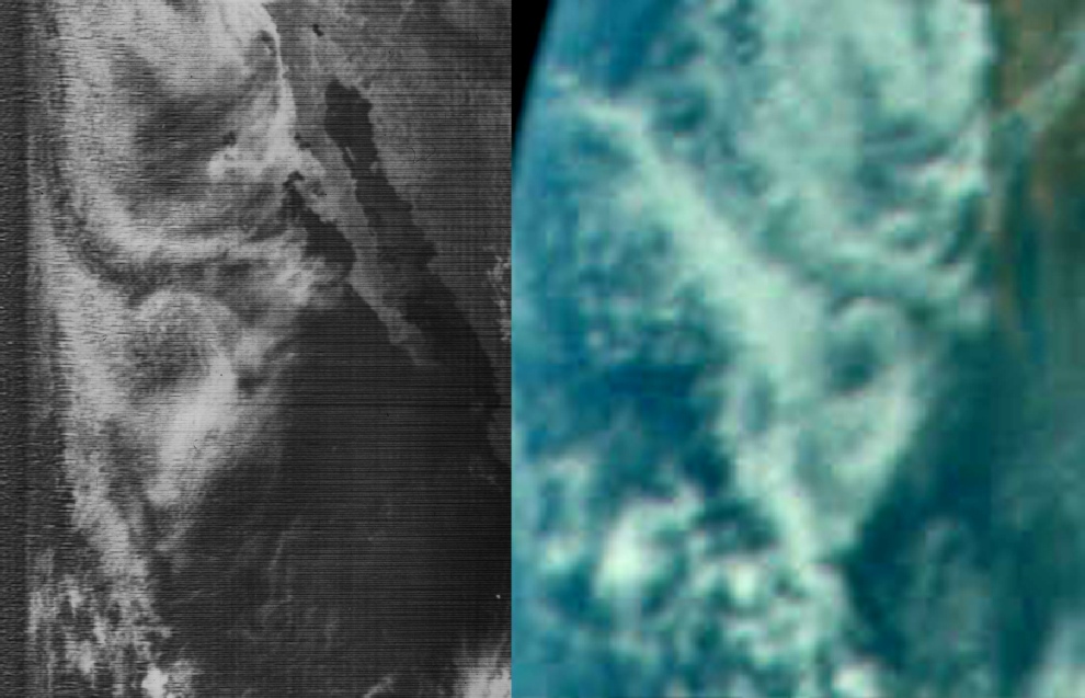
Figure 4.2.3.18: NMBUS-
At the risk of being repetitive, once again the Apollo image provides an excellent match with the infra-
Figure 4.2.3.19: Section of NIMBUS-
The NIMBUS pass started at 18:11, just 110 minutes before I estimate the Apollo image was taken, which certainly explains the closeness of that match.
Again, we have another photograph demonstrably taken shortly after this one in the form of AS10-
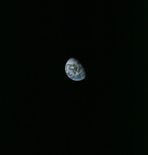
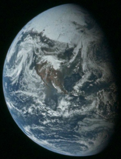
Figure 4.2.3.20: AS10-
A couple of hours after this photograph was taken we have another TV broadcast and another series of detailed descriptions of the view looking back home. Figure 4.2.3.21 shows the a still from the broadcast, again with 3D satellite reconstructions for comparison.

Figure 4.2.3.21: Still from TV broadcast compared with SkySafari depiction of Earth at the same time and 3D reconstructions using ESSA (left) and NIMBUS data (centre).
The TV broadcast took place between 22:24 and 22:49 on the 20th, and I’ve set Stellarium at 22:30. Here’s what the crew had to say for themselves before the actual broadcast start. At 53 hours and 6 minutes (53:06), or 21:55, they describe the following:
053:06:59 Stafford:…storm center over Alaska. It's finally started to rotate around and has developed into quite a system.
At 53:23 (22:12 GMT), there is a more detailed description:
053:23:06 Cernan: …the eastern seaboard from about the Carolina’s on up, just on the seaboard, is going to be covered with clouds and then into the Atlantic…I mentioned this morning there was a long cloud bank from the northeastern part of the United States into Missouri. It looks like now that that cloud bank goes from central Indiana up across Lake Erie, north-
Capcom then confirms that this description matches their weather map, but it isn’t clear weather this is some sort of synoptic chart or a satellite image.
The descriptions continue:
053:23:37 Cernan: Okay, Charlie. And I mentioned this morning there was a long cloud bank from the northeastern part of the United States into Missouri. It looks like now that that cloud bank goes from central Indiana up across Lake Erie, north-
053:24:24 Duke: Roger, 10. We're looking at a weather map that was just brought in, and we cast our vote with you, Gene-
053:25:13 Cernan: Yes. Yes, I understand. I think you'll see that big swirl of clouds Tom was talking about up Alaska way...Charlie, you asked Tom about the dense vegetation in South America. But if you look at the United States, the Mexican and greater American deserts are that orangish-
053:25:56 Duke: Roger. We copy that. It looks like this cloud system out in the Pacific is associated with another low-
053:26:21 Cernan: That's affirmative. That's going to be very easy to see.
While it isn’t easy to see the landmasses to which they refer, the cloud systems are certainly very distinct, and when compared with the next image taken a short while later it does become more obvious that they are accurately describing a real time view of Earth.
When the broadcast actually starts there are more descriptions, mostly tro try and help the ground understand what they’re seeing.
053:40:12 Cernan: Okay, Charlie. you are looking at the world rightsideup, as we know it. The Gulf of Mexico -
053:40:48 Duke: Roger. We copy. We see primarily just the blues of the ocean and the whites of the clouds. We have a -
053:41:21 Stafford: Yes, Charlie. That's Mexico and the southwestern United States, right there; and Baja California is on the left of that, and the right-
053:41:38 Stafford: It's awfully hard to ascertain the difference -
053:41:58 Duke: Roger. That helps us out here to locate ourselves, at least for me, 10; and I think I see where you are talking about now. We have one section of clouds that looks like it is almost a circular area -
053:42:35 Cernan: That's it, Charlie. The Gulf of Mexico is right smack in the center up and down of the world. If you follow the terminator down and went halfway and then went about halfway from there toward the rounder part of the Earth, you will find the Gulf of Mexico on that brown area you are looking at, between Mexico and the southeastern United States. That's Houston right smack in the center of that clear area...goes from Central America right on up into the states.
053:44:03 Stafford: Okay, Charlie. The total globe that you see there is bigger than what we actually see, since we have the zoom lens on and it is probably about one and one-
053:44:17 Duke: Copy, 10. As I said earlier, we are primarily getting the globe on a black background, and we see the white of the clouds and the blues of the sea with an occasional glimpse of what I make out as landmasses in the brownish. But, it is really difficult for an untrained eye to pick out the exact landmasses. We are sitting here with the in-
053:45:12 Duke: I think what it is, 10, is the landmasses and the clouds tend to wash out and it is a little hard to discern the difference; but looks like we can pick out the shapes of Yucatan, Florida, and Cuba, and the Gulf of Mexico.
053:45:40 Cernan: …If you follow up…the Gulf of Mexico there -
053:46:20 Cernan: And then way up on the upper left-
From this description that the cloud mass he is describing is the large mass over the northern US identified by the purple arrow in the next image, AS10-
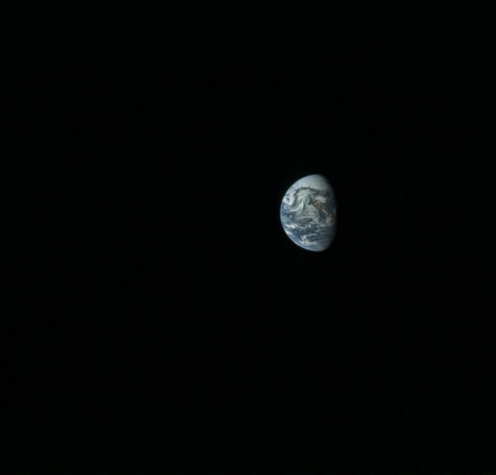
Figure 4.2.3.22: AS10-
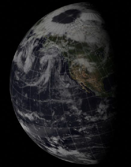
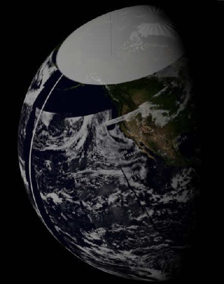
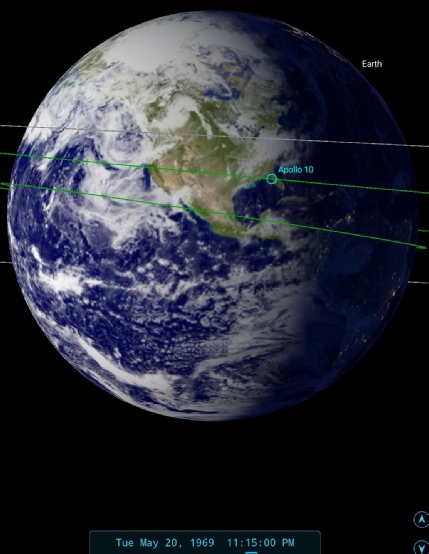
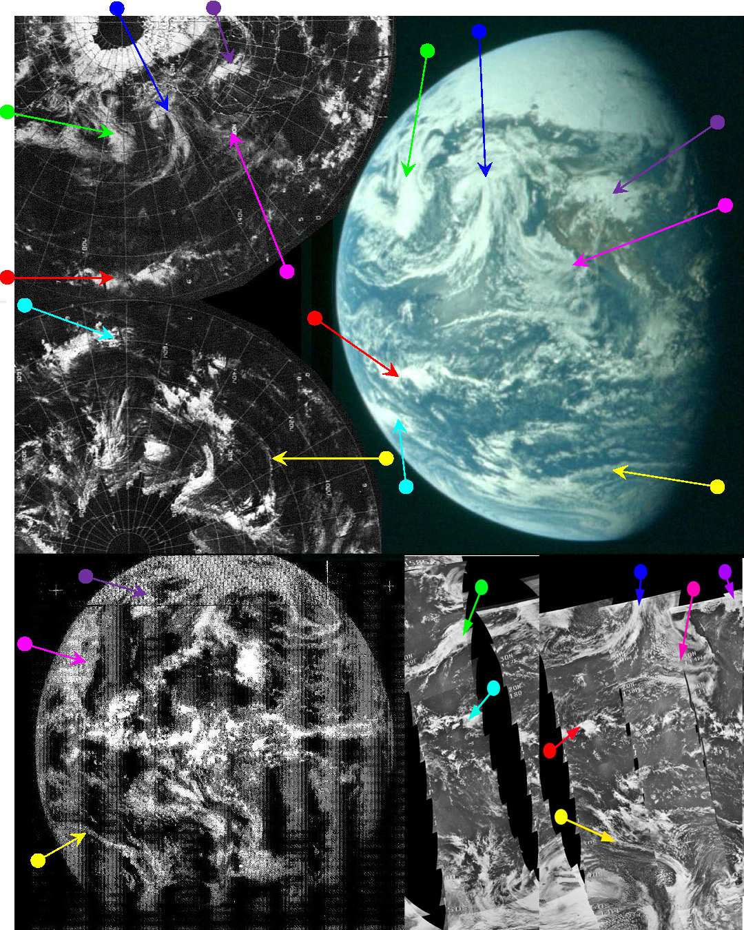
Figure 4.2.3.23: ESSA 9 (top left upper & lower), ATS-
The disappearance of most of south America beyond the terminator puts the time at 23:15, with the satellite images showing weather systems from the 20th. As far as the satellite timings are concerned, ATS is obviously from the same time as before, and nearly all of the land masses visible are now beyond its view. We can also see that the large swirl described in the TV commentary is identified by the blue arrow here. Not for the first time we have a very clear Hasselblad image showing exactly what was filmed and described in the TV footage.
As for satellite timings, ESSA's terminator position would have been on track 3 of its circuit, or orbit 1042, commencing at 18:09 on the 20th, but the area over the Pacific wouldn't be imaged for another hour after the photograph (track 6, orbit 1045). NIMBUS' track 489 was commenced at 14:55 on the 20th, and not all of the area in the photograph was imaged on the 20th.
The next photograph in the series showing rotation of the Earth is taken on day 4, so click on the links to get there.