4.9.3 -
Before we get to the next photograph, Schmitt continues his weather forecasting duties by describing what he can see at around 02:00:
044:26:14 Schmitt: Okay. Got a little information on what we were talking about yesterday with respect to southern Pacific weather, if you've got nothing else going on.
044:26:26 Roosa: Go; speak to me.
044:26:32 Schmitt: Okay, looks like a little -
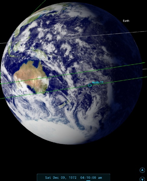
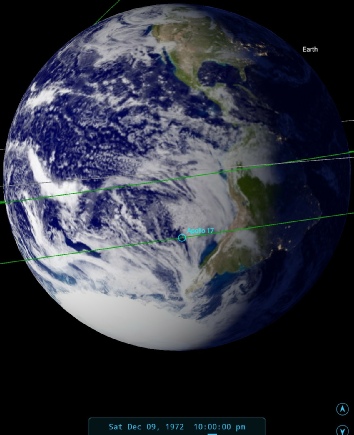
Let’s have a look at what should be visible at this point in figure 4.9.3.1.
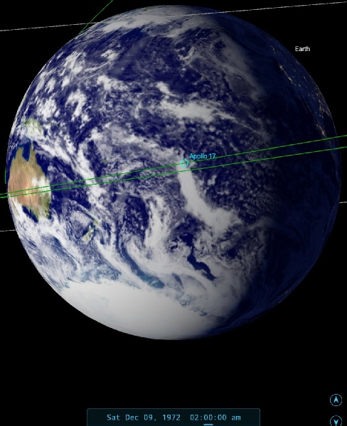
Figure 4.9.3.1: SkySafari depiction of the Earth at the time of crew comments compared with 3D satellite reconstruction.
The satellite image here is around 3 hours behind the Apollo 17 description, but there is a clear match with what Schmitt is recounting to the ground. Of particular relevance is the comment about the location of Papua New Guinea, which is indeed on the limb. A few minutes later Gene Cernan gets in on the act:
044:35:55 Cernan: Okay, I think that big storm that Jack was referring to -
044:37:13 Overmyer: Roger. [Pause.]
044:37:21 Cernan: South of Australia, you get a hint of a very large cloud mass, from there all the way down to Antarctica, that has the tendency to...
There’s a disruption in comms here, which is resumed in a few minutes:
044:40:17 Overmyer: Just wanted to get comm there again. We had some switchover there. You might be interested; we've got an ATS map in here from this morning. Just -
044:40:46 Cernan: Okay, Bob. And there is a very large cloudy air mass between Australia and Antarctica. It has a tendency to want to start a rotation, and you can see a hint of that; it's not too strong right now. We're seeing about three-
Again, they’re correct about the sunset, and about what’s going on beneath them. It’s interesting that Houston has access to an ATS image, which would be nice to have here!
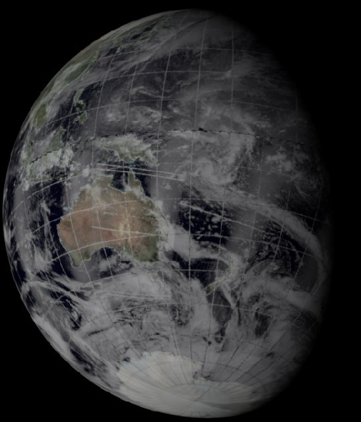
A couple of hours later, Schmitt updates his analysis, and figure 4.9.3.2 shows the view that he’s describing.:
046:35:56 Schmitt: I'm ready to update your weather in the Western Pacific, if you're interested.
046:36:02 Overmyer: Roger. Go ahead.
046:36:07 Schmitt: Still can't quite figure out what that circulation around New Zealand means. It looks like it's merging with some more weather to the southeast. I suspect it's stormy there, but I still -
20 minutes later he posts an update:
046:50:47 Schmitt: I need to make a correction. Roger. I need to make a correction. It looks as if that storm area that was in New Zealand yesterday has moved up across the two islands and is now sitting northwest. It's getting a little hard to identify the smaller islands in the pacific, but -
046:51:27 Overmyer: Roger, Jack. That's interesting because on my prog it doesn't show a thing down that area. This just may not be up to date here yet.
046:51:36 Schmitt: Well, there may be nothing down there except some cloud patterns and -
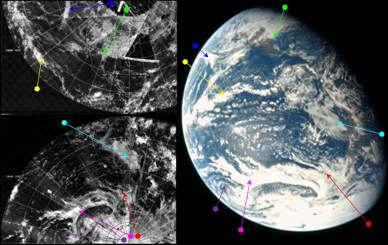
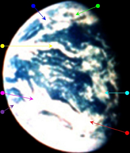
Jack continues his synoptic deliberations during the next hour or so, culminating in the next photograph in his long sequence. We’ll catch up on his narrative after seeing the scene he’s describing (figures 4.9.3.3 and 4.
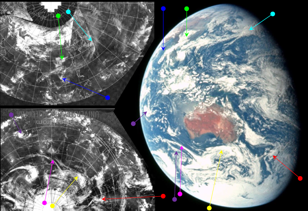
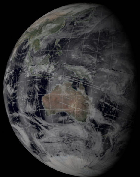
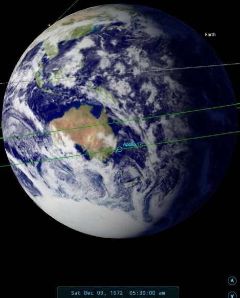
Figure 4.9.3.4: AS17-
Figure 4.9.3.3: AS17-
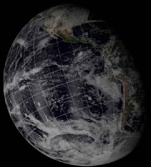
Such has been Jack Schmitt's influence on this part of the narrative of Apollo 17 that mention of the actual satellite photographs that are the point of this research has been almost put to one side. To redress the balance slightly, the satellite image used here, dated the 8th but showing cloud formations on the 9th of December, is a clear match with what Jack sees and describes from Apollo 17. The northern hemisphere mosaic has issues with data quality, and some of the features are difficult to identify clearly – particularly in the eastern part of the picture. There is a clear line on the mosaic inland of China's east coast where the clouds are much better defined.
It is still, however, possible to pick out the patterns. Therese (about we will hear from Jack later) is just visible, highlighted in blue and heading for landfall in Vietnam. Southern hemisphere systems are much better defined, and the clouds off Australia and over New Zealand are very easy to identify. The time markings suggest a rough time at the terminator on the NOAA mosaic of around 22:00.
Systems easy to identify in an image taken from a few hundred miles up are still easy to identify from over 150000 miles away, with the benefit of good monocular viewing equipment (anyone with a telescope will have a similar level of detail available to them of the much smaller Moon from much further away!). After the hiatus of testing the LM systems, Jack is able to return to his meteorological observations.
The emerging cyclone he described in the preamble to this photograph is the one identified with the purple arrow, and the front south of Brisbane in yellow.
Cernan’s comments from earlier are trying to describe the front that rolls up from Antarctica towards New Zealand, heads westward towards Tasmania before merging with a thin front off Perth. Closer examination of the Apollo image does show other systems with similar patterns below that large front, and the cloud mass is indeed fairly solid below that towards the ice sheets.
Schmitt's appraisal of Australia's conditions are spot on. He identifies the thin front to the south-
Later on he moves back to SE Asia, and the north-
046:59:36 Schmitt: Okay. That generally -
047:00:51 Overmyer: Roger, Jack. We've got it on our prog here. We don't show the one on the northeast part of Japan, but we do show a front prog for tomorrow morning going off of Taiwan and -
047:01:14 Schmitt: Roger. That's the one I'm -
The main front he is describing there is the one picked out by the cyan arrow, and rather than “north-
Capcom again tell Schmitt that they don't have all of the area he describes on their charts, but that what they do have matches what he's telling them. Schmitt then goes back to Australia and predicts heavy weather for South Australia in a few day's time.
047:50:30 Schmitt: Well, I still am, as a matter of fact. The old Earth's coming by. And, say, I mentioned a couple of fronts that joined together about 20 degrees south of -
That frontal system is picked out by the yellow arrow.
He then tells Capcom at 47:43 (c. 05:15 GMT) that:
047:59:15 Schmitt: Bob, we're still on November November frame 140, and I'm going to take two more pictures before I go to sleep.
Followed later by
048:14:53 Schmitt: Roger. One final word. I got those pictures; and, I tell you, that typhoon off -
048:15:26 Overmyer: Roger. We concur. The prog for 12:00 -
048:15:42 Schmitt: Yes; well, it's right there. Yes, it certainly is. It's -
048:15:59 Overmyer: Roger. It looks -
048:16:12 Schmitt: Oh, yes, you better believe it. It in really -
048:16:31 Overmyer: Roger. How're you getting that, Jack? Are you looking with the monocular now?
048:16:39 Schmitt: That's affirm. Monocular still gives real good resolution on the cloud patterns. [Music] Naked eye, you just see the masses; but with the 10-
So we have a pretty accurate time for the image under discussion of 05:30 GMT, and an examination of the Stellarium inset included in the previous figure shows that the distance between the terminator and Australia matches exactly what it should be, as does (allowing for the relative viewpoints of Stellarium and Apollo 17) the distribution of Asian land masses on the western limb.
A reminder here that capcom isn’t looking at satellite photographs, the prog charts are ‘prognostic’ charts -
The photographs to which he is referring are general pictures of hurricanes and tropical storms, not this specific one, although we do know that photographs of a nicely formed spiral Therese with a defined eye were around before launch. Therese has indeed moved west, and is due to make landfall in Vietnam in the very near future. Capcom's weather charts also show a tightly formed storm, and predict that landfall will be in another 6 hours time. Jack is even able to describe Therese as being roughly the size of South Vietnam, which is a reasonable estimate of its diameter.
We have a couple of Landsat passes to examine on this date that cover areas of this image, namely central Australia and Antarctica. Earth is getting increasingly distance and the amount of resolvable detail in close up is reducing all the time, but we should at least have a go. Figure 4.9.3.5 gives the details.
Figure 4.9.3.2: SkySafari depiction of the Earth at the time of crew comments compared with 3D satellite reconstruction.


Figure 4.9.3.5: Landsat paths shown on AS17-
The most obvious feature of the two sets of satellite views is that central Australia is clear of cloud in both Apollo and Landsat, but to be fair it often is. Antarctica is covered in ice in both images, but despite the lack of detail you can make out the changes in contrast. The Landsat view shows clear sea in a couple of coastal patches, and there is a similar area to be seen in the Apollo view, but this is not unusual and it also assumes that I have the right area under scrutiny -
We also have some declassified imagery from a Hexagon satellite covering some of this photo. Figure 4.9.3.6 shows the area concerned.
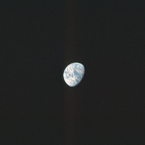
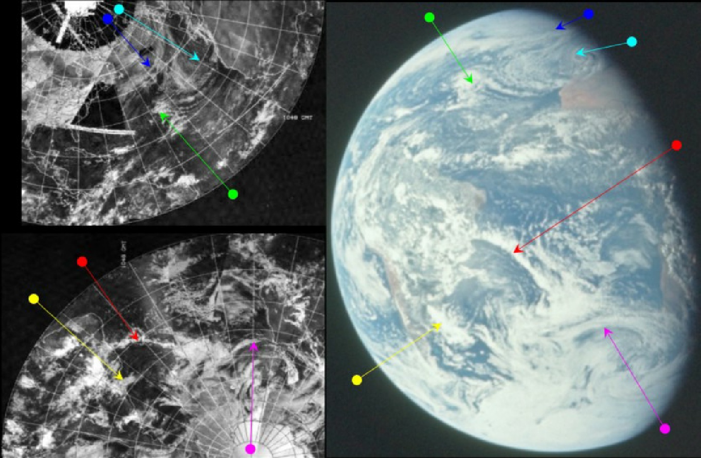


Figure 4.9.3.8: AS17-
Figure 4.9.3.7: AS17-
The terminator on the image runs almost through the prime meridian, at least in the northern Hemisphere, and has been set by Jack’s confirmation of the time given below.
The mosaic again suffers from very poor image quality, with lighter clouds difficult to make out, and a large data 'hole' in the north Atlantic off the coast of north America. Sub-
As far as the weather systems themselves are concerned, we again have Jack's observations, found at 58:39 MET in the transcript:
058:39:45 Schmitt: Okay, Gordy. That little storm -
Schmitt's description of the large and spectacular frontal system that used to be in the north Atlantic is again accurate, and it is interesting to note that while his description (and the observable reality of the photograph) find the leading edge of that storm (indicated by the green arrow) inland on north Africa, it is still on the shore 5 hours or so earlier in the NOAA mosaic. The tight central spiral of cloud is also not visible on the NOAA image, but it is possible that NOAA's sensors and/or the mosaic compilation process have not used the required level of detail to see what are obviously thin clouds.
The large system he identifies off the Cape of Good Hope is picked out by the magenta arrow. The other system picked out by Jack is the one that was over Buenos Aires, which is picked out here by the yellow arrow. In the Apollo image this storm has moved almost completely out to sea, as Jack describes, but in the NOAA mosaic it is still half over the Argentinian capital.
A few moments later, at 59:20 MET, or 16:50 GMT, Schmitt tells us that:
059:20:41 Schmitt: While I got you, I took three pictures of the Earth I thought I might have moved one of them. And we're on frame 145.
The image used in this particular analysis is indeed one of three, rather than the pairs of images Schmitt has been taking to date.
The next images in magazine 148 show the CSM as viewed from the LM, as Cernan and Schmitt carry out some telemetry checking from the LM. Following this sequence of pictures, the next one of Earth is AS17-
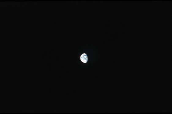
Figure 4.9.3.9: AS17-
Before seeing what Cernan and Schmitt have to say about their view of Earth when these were taken, NOAA should be given a quick examination. The image used is from the 9th of December, and for once the quality of the cloud representations is roughly equal between the hemispheres, although there is a substantial gap off the east coast of North America. For this photograph this gap is of no consequence as it is that part of the Earth is no longer visible. The two most obvious features are the large loop of cloud from the Antarctic up towards Australia, and the '<' shaped twin bands of clouds stemming from the western Pacific towards California and south America. The terminator line just on from the US east coast would have been scanned by NOAA at roughly 15:00 GMT.
As for what Apollo's image shows us, it is Cernan who takes up the narrative in the build-
062:52:11 Cernan: Okay, now that we got another look at you, Gordy, it looks like Houston might be right on the fringes of either being clear or clearer. The entire Gulf is pretty nice. Florida looks pretty clear, and Mexico looks pretty clear. There's a big air mass of clouds that looks like it picks up somewhere around the coast at Houston, heads on up north, and then covers most of the Midwest and the East, from about the middle of Mississippi, Alabama, and Georgia on north. It's clear enough now to even see the coral reefs down off of Florida. And it looks like west Texas is probably also pretty clear, at least in a run from east to west. We can see Baja, and on up the coast of California up north.
His description is, as expected, an accurate one. The cloud mass covering Houston and northwards is picked out by the green arrow, and his assessment of the clear areas matches what we can see. Schmitt then takes over the narrative, effectively repeating Gene's description:
063:11:52 Schmitt: Gordy, this is Jack. I think Gene was right. You got some -
063:12:24 Fullerton: Okay, Jack, thanks for the warning.
063:12:30 Schmitt: Clear behind it, in Arizona and New Mexico and maybe southern Colorado, it looks like there may be another front stretching, or maybe it hits northern Arizona and Utah and up through northern Colorado, and on in to Canada, trending northeast.
063:12:57 Fullerton: You're calling it right on, Jack. I'm looking at the surface chart, and that's about what we see. [Long pause.]
063:13:20 Schmitt: Looks like a low might be developing on that one -
before commenting on the southern Hemisphere:
063:14:29 Schmitt: One of the more unusual features is developed -
063:15:49 Fullerton: Roger. [Pause.]
063:15:56 Schmitt: I'll get some shots of that next time around. That's a spectacular pattern. You almost get the feeling that the cold airmass moving out of Antarctica streams for a while north/south. And then it picks -
The mushroom pattern is the system identified by the magenta arrow, and again the description is very accurate, right down to the 'streamers' that head northwards from roughly where the magenta arrow head is., and the high clouds mentioned next to Tierra del Fuego are marked by the red arrow.
After a brief discussion on whether he can see any changes in the Ross Sea,
064:19:57 Schmitt: Yeah, about this icepack in the Ross Sea. The -
Capcom given another mention of their use of satellite images, saying at 64:21 MET:
064:21:13 Fullerton: I'm looking at a satellite picture here, which I guess is around 12 hours old though. But over to the east of Australia, maybe about a continent width east of Australia, there's a really striking long frontal system -
Capcom's description matches what Jack & Gene have already described, but his ATS image must lack the detail of their monocular view of a colour Earth.
At this point Gene takes over again, and discusses the various sub-
064:23:41 Cernan: Okay. Now Jack and I may be talking about two different frontal systems or patterns, but the one I think you might be referring to is the one I referred to yesterday as a ruffled parrot's beak. Actually two of them tied together, one starting up probably southeast of Australia and -
Gene is right in thinking that this is the same weather system he described earlier, and all three of them are describing the same system, but Jack's “mushroom” analogy is the better description of it. Capcom tells Gene that his ATS image doesn't go as far south or west as far as he is describing, after which Gene continues to describe the same system:
064:25:15 Cernan: There is some tremendous -
In this passage Cernan first describes the system marked by the purple arrow – where there are several circles of cloud at one end of the 'mushroom'. The other system he mentions is at the eastern end, just below the clouds marked by the red arrow.
Confirmation of the timing of the Apollo photograph comes from Schmitt at 64:28 MET, when he says that:
064:28:22 Schmitt: Gordy, I just took two pictures of the Earth at the present time, and those are, right now the camera is on frame 153.
and after another brief exchange about what Capcom's ATS image covers goes on to give his description:
"...that mushroom pattern we've been talking about, on either edge -
A few moments later, Jack confirms that he has taken some more photos of Earth with the Nikon:
064:48:12 Schmitt: Gordy, I just took a series of pictures of the Earth with the 35-
This suggests a 20 minute gap between the Hasselblad and Nikon photos, so it is worth looking to see if we can notice any discernible rotation between the two (figure 4.9.3.11).
So we have both Gene Cernan and Jack Schmitt describing weather patterns, many of which are not available on Capcom's ATS images, showing an Earth that matches exactly what should be visible according to SkySafari. The weather systems they see and describe are matched by NOAA's satellite mosaic, and there is even a consistent and measurable degree of rotation between the two images.
In addition to the civilian satellites recording the view we also have Corona images taken on this date and there are two small areas covered of western USA. The images concerned are shown in figure 4.9.3.12.
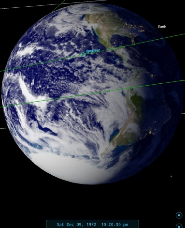
Figure 4.9.3.11: AS17-
Figure 4.9.3.10: AS17-
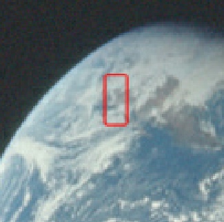
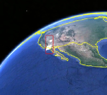
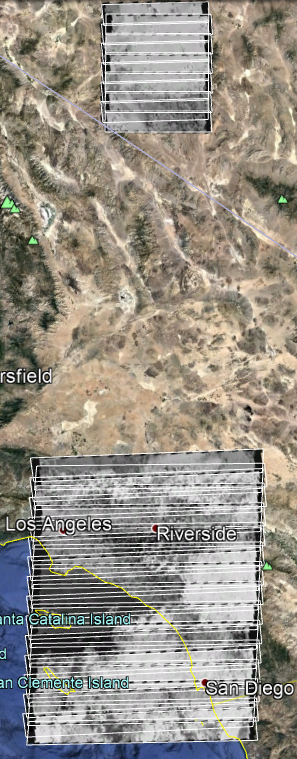
Figure 4.9.3.12: AS17-
What we have visible in the Corona image is a band of cloud stretching from offshore onto land and we have the same pattern visible in the Apollo image. The Apollo image was taken at around 14:00 local time, and the Corona image was likely to have been taken an hour or so before that. The patch of cloud shown in the northernmost images taken by Corona is also matched well by the Apollo photograph. As with other Corona images it has not totally conclusive, but it is vedry consistent.
We have another satellite to choose from as well for this image, namely a long Landsat pass over central Canada and the USA. There is also a pass over a small section of British Columbia, but it is at such an angle on the Apollo image it would not provide any useful information. Figure 4.9.3.13 shows the relevant locations and details of these images.
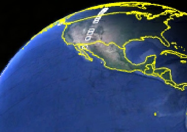
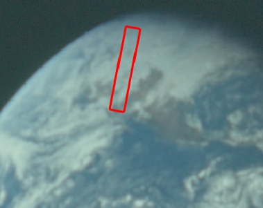


Figure 4.9.3.13: Landsat pass over North America shown in AS17-
As usual there is a broad correspondence with the Apollo image -
The timings given for the remaining images in the mission are open to some confusion, as there was an update to the mission clocks during TLC. Updates to the clock were done where, for example, a launch delay introduced a lag between the planned time of events for the mission (eg ultra-
Technical problems during the countdown sequence for Apollo 17 introduced a substantial delay to the flight plan, and as a result at 65 hours GET 2 hours and 40 minutes were added to the mission clocks. This event is referred to in both the timeline and the mission transcripts referred to here, but there is no apparent alteration to the actual times recorded. It is assumed that times referred to by Capcom and the crew are the adjusted times, while the times recorded in the documents themselves are the unaltered original elapsed times. Certainly when photographs are recorded as being taken, the recorded times match those derived from Stellarium, rather than the time 160 minutes later. The analogy here is that, for example, the astronauts are using daylight saving time, but all the documents continue to record GMT.
Having accounted for any likely discrepancies in what the various mission personnel may say and when they are recorded as saying it, we can move on to discussing the next image in the sequence.
That next photograph of Earth is one that wasn’t originally considered for this project, and it was only when looking at the descriptions in the transxcripts that I took another look. The transcripts says this:
068:04:33 Schmitt: Okay, Bob, we're getting ready for the ALFMED. I just took a red-
So this is a good couple of hours later than the previous Nikon photograph and opur first test for working what the actual time is.The AFJ gives the adjusted time, so in terms of this analysis 68:04 is the equivalent of 65:24 under the old clock, which is 22:57 GMT. Figure 4.9.3.14 shows the Nikon photograph.
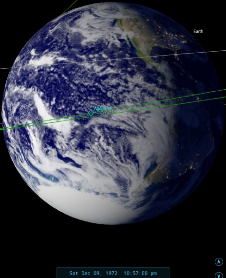
Figure 4.9.3.14: AS17-
It’s difficult to compare with the the previous Nikon image, as it is so over-
The timing of the next image, as you’ll see when you follow the link to go look at it, is open to debate -
Hexagon shows a nice clear demarcation at the edg eof a cloud mass, and it’s location seems to be consistent with the system identified with the green arrow in figure 4.9.3.4. We don’t know precisely when the Hexagon image was taken, so some allowance fo rcloud movement needs to be made!
Next up in magazine 148 is AS17-
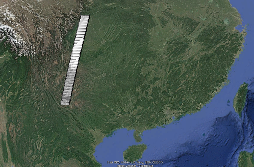
Figure 4.9.3.6: Hexagon satellite imagery compared with the same area of AS17-