4.9.9 - Apollo 17 Day 9 - Back to orbit
During orbit number 62, the first 55 frames of the Metric Imaging camera use an oblique angle to take images of the lunar surface, capturing the lunar horizon as they do so. As this orbit reaches Mare Smythii, the camera captures a sequence of images showing Earth rising. The ASU have animated that sequence here. Unlike other Earthrise sequences, this capture is entirely coincidental: the photography is automated, and it just so happens that Earth is in the right place, as opposed to other sequences where the astronauts have set out to photograph this orbital feature.
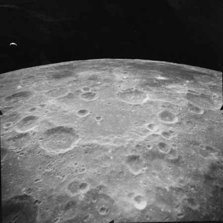
The image chosen from this sequence is AS17-M-2193, and while a high resolution version is available here AIA and is shown in figure 4.9.9.1, a more useful version of the view of Earth can be found by zooming in to the image at the LROC Viewer. That viewer also givers a precise time for the photograph. APE data from here show the start time of the entire sequence as 20:08.
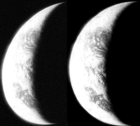
The distortion introduced by the oblique angle can be corrected using image editing software, so that the position of landmasses can be better approximated in comparison with SkySafari. It must be stressed that the only alteration carried out here is to alter the brightness and contrast of the image, and to make the crescent shape of the Earth less distorted - see figure 4.9.9.2.
Figure 4.9.9.1: Apollo 17 Metric Mapping Camera image AS17-M-2193. Link given in text. Below is the location of the craft when the image was taken (purple marker).
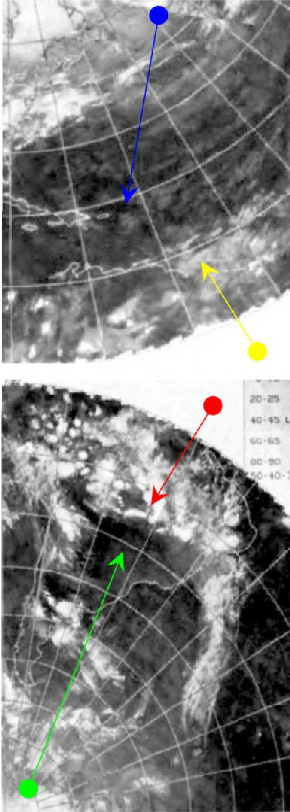
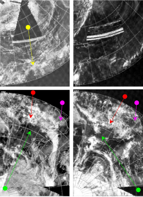

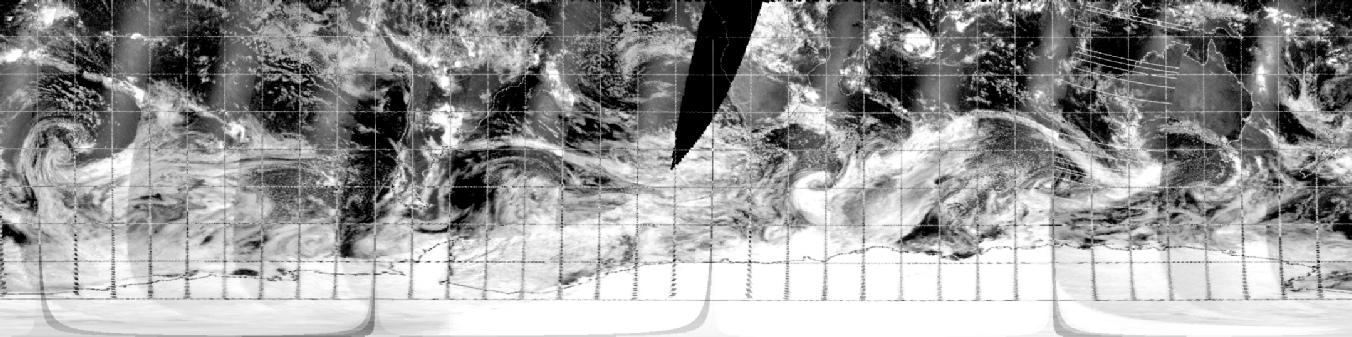
Figure 4.9.9.3: Close up of image AS17-M-2193 from the LROC viewer compared with NOAA IR spectrum image from 15/12/72 (right), visible spectrum from 14/12/72 (centre right) and 16/12/72 (right), and SkySafari depiction of time at terminator. Left is partial 3D reconstruction of digitally restored NOAA data from the 15th.
The Science debriefing session in January 1973 has this about the image sequence:
“We did extend the camera again for rev 62. I have had the chance this morning to go through all of the mapping camera photography and do find an anomaly at the beginning of rev 62. Ron, maybe you can explain what actually happened there. The first half a dozen frames on rev 62 are a westward-looking oblique so that we actually see the lunar limb and see the the earth above the lunar horizon….They are the only mapping camera pictures we have with the Earth disk in them, so they are interesting from that point of view. “
The statement there is from Fred Doyle, one of the people responsible for Apollo’s photographic systems. While Ron Evans replies that he was “really trying to get Earth”, it’s not clear if he was joking. It does, however, confirm timings.
The quality of the image is still relatively poor as the main focus of the mapping camera was the lunar surface, and thus only broad patterns can be made out rather than precise detail. This problem is compounded by the lack of visible spectrum data from the satellite, but it it still possible to show that the area over Argentina is relatively clear (green arrow), and is bounded north and south by cloud (the red arrow identifies the northern cloud mass). The IR image and the visible spectrum images from the 14th both indicate an area of coastal cloud off South America's Caribbean coast (yellow arrow) that is absent by the 16th, and that forms a separate lobe of cloud to the Amazon cover.
The north Atlantic & Caribbean areas are difficult to discuss given the presence of a data anomaly over most of it in the visible spectrum images, but the IR photograph from the 15th does suggest light cloud cover over the former compared with thicker cloud over the latter. The blue arrow shows similar areas of circular cloud masses over the Caribbean. The IR camera does not pick up the much colder air masses over the Antarctic.
The partial view of the southern hemisphere in 3D corresponds well with what’s visible in the MMC image.
Despite the relatively poor quality view of Earth we have here, there is still a Landsat path with which we can compare it. That path was commenced at 13:06, 7 hours before the Apollo image, while a pass over Newfoundland was taken at 14:34. The latter pass is is in an area almost entirely covered by darkness at the time of the Apollo image so is not covered here. The details are given below in figure 4.9.9.4.
SkySafari suggests that what should be in view at that time is South America, with some parts of the southern USA also visible, cloud cover permitting. The crescent Earth's size is a good match for that shown by SkySafari, and although the original has been changed, the dimensions of the widest point are still consistent..
The first step to comparing with satellite images is to determine when this image was taken. Orbit 62 was commenced at 209:39 on the 15th (19:32) and the photograph is recorded as being commenced at 209:26 (20:19). The mission transcripts record a conversation before the commencement of this orbit marking the opening of the Mapping Camera before LOS at the end of orbit 61. There is also this conversation as the crew approach Mare Smythii (visible on the lunar horizon in figure 4.9.9.1) on orbit 62 at 209:21 minutes just before re-establishing contact with Houston:
CDR: There's ... Oh, fantastic. That's the first one I've seen. Out 5. Beautiful, beautiful. Look at that ... Look at that - Let's get it the next time around .... in this attitude, Ron?
CMP: Yes.
CDR: Yes. Let's - Yes, that's - Oh, man. Look at that.
CMP: I don't know, I've looked …
CDR: Yes .... a little late. We needed it just when it came up. Yes, let's make sure we do that. That is beautiful. It's just unbelievable.
So that all ties in. Let’s see if the satellite evidence does in figure 4.9.9.3.
Figure 4.9.9.2: View of Earth from AS17-M-2193 (left) compared with adjusted (right).
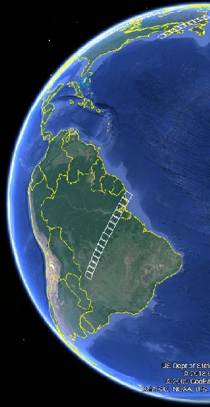
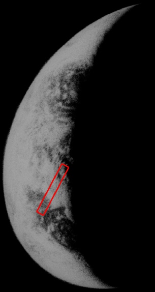

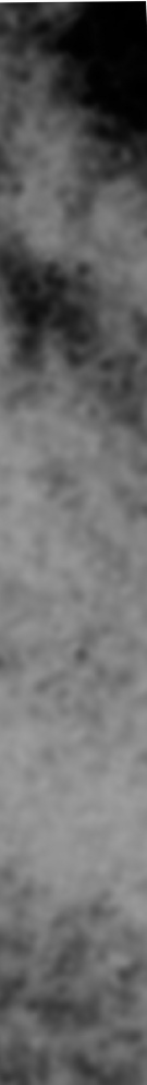
Figure 4.9.9.4: Landsat paths plotted on Google Earth (top right), AS17-M-2193 (bottom left) and in close up for South America.
The first part of the question we need to ask here is ‘do we have the locations correct? For the South American pass we can make out the weather patterns more clearly as well as the angle of the western coast along Peru and Chile, so it seems reasonable that we have. The clouds here are relatively easy to interpret - we have an area that is clear on the coast, a belt of cloud across northern and central Brazil, with clear areas to the south, and again this is reflected in the Landsat view.
Because the photography data available tell us where the CSM was relative to the surface below it, and how high up it was, we can again try and generate ephemeris data to see what should have been visible on Earth - here it is, using an altitude of 113 km and coordinates of the sub-spacecraft point of 152.224, -22.2041:
Date__(UT)__HR:MN Azi____(a-app)___Elev ObsSub-LON ObsSub-LAT
*******************************************************************
$$SOE
1972-Dec-15 20:00 * 219.007446 -54.131595 352.213431 12.738971
1972-Dec-15 21:00 * 219.077742 -54.106952 337.735907 12.963517
$$EOE
According to that, we should be seeing somewhere around 12 degrees west of the Greenwich Meridian and almost 13 degrees south of the equator, see figure 4.9.9.5
Figure 4.9.9.5: Location of the Observer sub-point at the time of the photograph.
Even accidental photographs of Earth are a match for the satellite record. The next views are taken on the next day, so follow the link.
