5.8: The military own NASA
Again, there are undeniable links as NASA launched them, but the military had their own satellite programme. The Apollo 11 'rescue' story is indicative of parallel development, not cooperation. If the histories presented in chapter 2 are anything to go by, the military were in fact frustrated at NASA's lack of speedy progress in the field and went their own way.
Of course the conspiracy theorists will argue that “they would say that, wouldn't they?”, but even with a proven link between the military, NASA and the Apollo programmes, this does not invalidate the evidence presented here.
The military were obviously involved in the Apollo programme even if their role was only to pick up the newly returned astronauts and provide support through ARIA, but the question there is “so what?”. Does military involvement mean that Hurricane Bernice didn't exist? Or Tropical Storm Therese? Or any other of the hurricanes and cyclones visible from space in the Apollo images showing storms where they should be on the dates they should be there and in the correct configuration?
The weather is not a military secret, neither were any of the weather satellites that provided the information about the weather, and neither was that support for Apollo by those weather satellites.
The military also made use of civilian satellites, indeed this article from the 1960s suggests that the weather satellites are being used for military purposes.
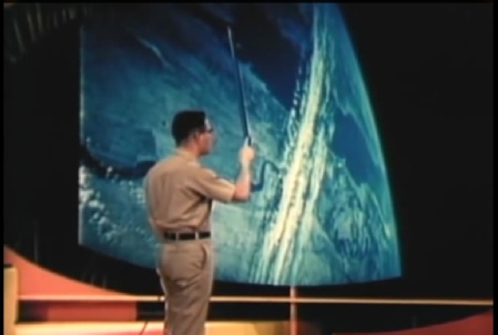
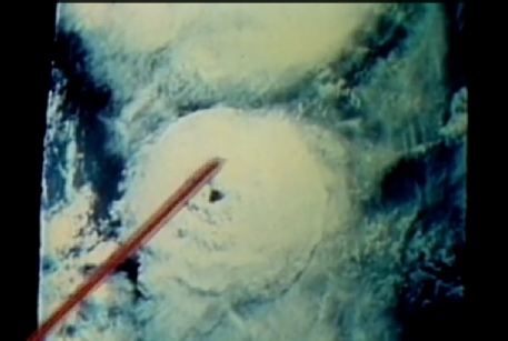
Several videos exist from 1971 of seminars given by the USAF as an educational film to trainee military meteorologists. ATS, ESSA, ITOS and NOAA satellites are directly referenced, and photographs from the Gemini program are used to illustrate cloud patterns and types. In a seminar on cloud types (part1 here, part 2 here) Gemini images are compared with satellite images -
The second seminar on cyclonic systems (part 1, part 2) also uses a Gemini image, but is more focused on the satellite records. Figure 5.8.1 shows some examples from the presentations.
We shouldn’t have to point out here that obviously this are Apollo images in the public domain -
Interestingly, in terms of the discussion on how much was achievable technologically, they discuss matching up satellite images by hand, as well as how the data from the advanced vidicon system was translated into georectified projections. They also emphasise the need for a complete arsenal of meteorological data and geographical understanding in order to interpret satellite data correctly. Satellite records do not automatically give rise to perfect understanding of the weather, understanding the weather allows you to interpret satellite data. This is the case with or without a uniform.
An additional argument concerning the military involvement is they had their own satellites up there, and perhaps they were of superior technology that would have been used to somehow generate the information needed to re-
Well we do know that they had a separate programme of satellite development and launches that they used to support their military campaign in South East Asia and to keep an eye on the Russians. It has been suggested that these produced better quality images, but this is a bit of a red herring as while the photographs may have been better, they were still collected at the same time and collated in the same way. A weather photograph taken on the launch day of Apollo 11 is going to show the same thing no matter what took it.
A second factor to consider here is the purpose of the military images. On the one hand general weather conditions were useful for planning air campaigns, but on the other they needed clear conditions to see the ground, and much of the imagery they collected was designed to do the latter.
The CORONA missions, for example, were not there to predict the weather, and because of the way they operated they would have been useless in the context of gathering data that would be of any use in faking Apollo images.
To illustrate this we can use this website to look for the declassified images from CORONA and see what they show. What we find is that there are very few from the Apollo mission dates, but we do have some luck with Apollo 8, where we have pictured taken on launch day taken over California. The metadata from the search results (source) show that it was taken by a CORONA probe, probably launched 12/12/68 (source).
What does it show? Figure 5.8.2 shows a view of 20 of the photographic strips superimposed on Google Earth (if you register on the site you can export search results as a kmz file).


A) Gemini image S66-
B) Gemini image S66-
C) AS09-
D) AS09-
Figure 5.8.1: Gemini and Apollo images used in USAF meteorology seminars


Figure 5.8.2: Corona imagery taken on 21/12/68 in close up and regional context
So far so good, and what we need now is a close up view of California from Apollo 8 with which to compare it. The best candidate is AS08-

Figure 5.8.3: Corona images compared with AS08-
There is an argument to suggest that the white band visible in the Corona images matches a band in the Apollo photograph, but it could equally be something else. We also have no data on precisely when the Corona images were taken, and they could be some hours apart.
If you’re wondering why the Apollo view (which I have level adjusted and sharpened) isn’t particularly good, figure 5.8.4 shows the area in context.
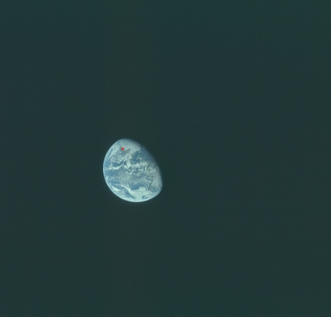
Figure 5.8.4: AS08-
It should be obvious that it would take quite a few Corona missions to cover the area needed to reproduce an Apollo image!
It’s also worth reminding ourselves of the somewhat turbulent relationship between NASA and the military. The military were frustrated by NASA’s slow progress, were unhappy with the quality of the products they were offered and did not like the risk of some very secret and occasionally not quite officially funded projects potentially being made public by using NASA launch facilities and hardware.
NASA, for their part, did not like military intrusion into their civilian organisation and resented taking orders that intruded into their own mission goals. The excellent, but still heavily redacted ‘History of Satellite Reconnaissance’ is well worth a read if you want to explore the military’s satellite development programme.
The story of the supposedly secret photographs that showed the risk to Apollo 11’s splashdown is a perfect illustration of how NASA and the military’s satellite programmes had completely different priorities. They co-
This 1973 edition of military magazine “Commander’s digest” (complete with an Apollo 16 image on the cover, figure 5.8.5), talks cooperation with NASA and about civilian sources of data, saying:
"DoD relies on the National Oceanographic Atmospheric Administration for some of its meteorological data needs, and DoD requirements are considered by NOAA and NASA in planning and developing these systems."
The two sectors share information and manage their efforts, using the Aeronautics and Astronautics Coordinating Board as an intermediary, but they are definitely separate. This report identifies the role of that Board as one of preventing duplication, coordinating work and exchanging information.
So, military satellites are a bit of a red herring. Detailed or not, covert or not, they suffer the same issues as civilian ones. It doesn’t matter where the information comes from, it’s either reliable or it isn’t. The weather is the weather.

Figure 5.8.5: DoD in house magazine showing an Apollo 16 image on the cover.