NASA (as well as popular radio ham journals) even sold documents showing you how to do it, such as this one. The images were used in many journals and research programmes, even daily newspapers and no-
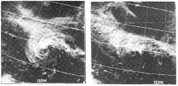
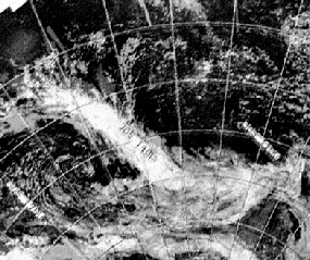
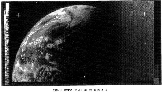
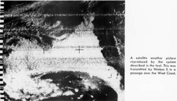
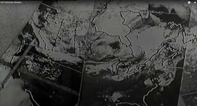
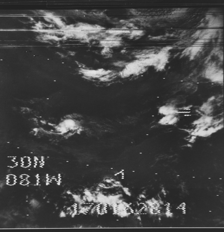
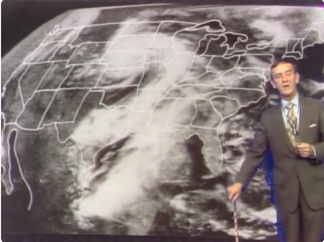
Figure 5.9.10: Hurricane Bernice on July 15th 1969 (left) and 16th (right).
The quick answer is: they couldn’t and didn’t. They were relying on ground and atmospheric data to predict the track of the hurricane, there is no way they could predict that it would end up in that shape.
They also didn’t have weather satellites “long before” Apollo -
"Knowledge of the physical behaviour of this kind of storm has progressed to the point where it is possible to issue alerts and provisional warnings to the public for areas which may be affected by them. But so far, it is impossible to predict the exact times and locations at which these severe storms may occur."
and
"The public benefit [of satellite information] is tremendous but the system is too new for its potential to be fully realised"
So even after Apollo had finished the science of satellite meteorology is still in relative infancy and could not do what Jarrah claims. This 1968 article also makes an interesting point when discussing the use of satellite data in predicting the development of hurricanes:
“Satellite data, which have become increasingly available during recent years, have helped in the detection and tracking of the hurricanes…They have not been used, however, in the development of forecasts of hurricane motion”
Showing that, during the Apollo era at least,while you can tell where a hurricane might be heading, you can’t tell what it will look like when it gets there.
Even by 1972 we have comments like this in the Mariner’s Weather Log,
“The meteorologist is often asked whether satellite observations have reduced the need for ship reports. Quite the contrary is true. Before the satellite meteorologist can understand what he sees in the pictures, he must compare them with other known data…”
Showing that satellite images were not (and still are not) the be all and end all of weather forecasting.
This paper from 1975 looks at the use of satellite imagery to predict hurricane development, and is interesting in that it uses images downloaded in Berlin from US satellites. However, in a response to it a contributor to the journal notes the need for experienced satellite image interpreters and wonders whether different people would arrive at different interpretations. Clearly the early years of satellite meteorology not only required the development of instrumentation that complemented visual ones but also the training of meteorologists in interpreting the data correctly. Even by the mid 1970s this was still under debate.
This page, written to commemorate 50 years since Apollo 11’s landing, as well as this article, use modern computers to input the known weather details for Apollo 11 and 17 to see what the computer could come up with. It is close, but even modern technology can’t get it absolutely right (figure 5.9.11). You could not, absolutely not, have predicted the Earth as seen by Apollo using the weather data they had.
The images were also distributed to newspapers well in advance of the events they related to, and again you may have noticed regular inclusion of images printed in the Sarasota Herald Tribune every day that could not be manipulated after the fact. Figure 5.9.9 shows one issued in advance of Apollo 12’s splashdown, and while Apollo 12 doesn’t have any images of Earth taken on this date it does show that the images were available and not some carefully controlled secret.
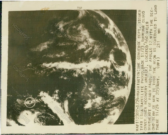
Figure 5.9.9: Press photo sold on eBay showing the satellite image of landing area of Apollo 12 compared with ESSA view of the landing area on the 22nd (top and bottom left) and the 23rd (bottom middle and right).
There are a couple of things worth pointing out here. Firstly, we can check the ESSA data to make sure that it is actually from the date it is claimed to be, and indeed it is. The cloud patterns around the landing area on the 23rd are very different on the days 22nd (there is no global ESSA mosaic for the 24th). The second point is the source -
The point remains: the satellite image was freely available and published in a newspaper.
A further indication of how available these images were is indicated in this paper. It is based on the activities of a UN cruise off West Africa using a Bureau of Commercial Fisheries vessel (the ‘Undaunted’) registered in Miami. The vessel was fitted with receiver terminals for both ATS and ESSA satellites. The authors discuss how the images were obtained and their quality, give a couple of example, and also make this comment:
“To supplement the shipboard TV -
At the time Angola was still effectively a Portuguese colony. Not only were they able to download them on board, they were able to get copies from an African observatory to verify that their images were accurate. Likewise this article, discussing what was then Rhodesia’s attempt to download satellite imagery for weather forecasting says:
“Meteorological Office technicians now regularly record the pulses emitted by weather satellites, particularly Nimbus II, as they pass over southern Africa – but instead of using the sophisticated equipment designed for the purpose which may be imported from Britain or America at a cost of between £10 000 and £18 000, they use equipment designed, constructed and adapted in their own workshops at a cost of less than £200.”
and
“Outside Rhodesia, Kenya is believed to be the only country in Africa at present tapping the information available from the American weather satellites as they cross and re-
Two African countries there helping themselves to satellite data freely available. Similarly this article describes how
“…in 1974 in an attempt to investigate the possibility of receiving satellite signals. Results with relatively unsophisticated apparatus showed that these radio signals could be tracked very well. Since very strong signals were received from the weather satellites ESSA 8 and NOAA 3, it was decided to develop the necessary apparatus for the demodulation of picture data from weather satellites.”
The page also mentions Russian Meteor satellites and their broadcasting frequencies, while this report to the US Senate details meteorological data exchanges with the USSR. Countries all over the globe were clearly making use, officially or otherwise, of the satellite transmissions showing the weather.
Given the ready availability of satellite transmissions and the relative ease of decoding them, suggesting that the satellite images themselves were faked really is clutching at the flimsiest of imaginary straws.
A side argument here is a claim by some morons (specifically Jarrah White, but others have joined in the straw clutching) that satellites had been used by NASA to predict the weather, then they were able to predict where the clouds would be and therefore make fake images to put in the broadcasts.
Here, for example, is Jarrah’s knee-
“...these videos have been compared with photos of earth taken by weather satellites in orbit at the time. Naturally, the pro-
I’d argue first of all that his response is typical of liars who make stuff up about Apollo -
Jarrah also says that
“Apparently the cloud formations seen in these telecasts are similar to those seen by weather satellites”.
Here’s the thing Jarrah, they aren’t similar, they match perfectly, which is remarkable given that the images hadn’t been completed at the time of the broadcasts. The use of the word ‘apparently’ also suggests he hasn’t actually seen any of the satellite images, so he’s trying to pass a judgement without knowing what he’s actually making a judgement about.
As was discussed in the introductory pages of this research, in the early days of satellite meteorology weather images were used to verify other data, not to predict the weather. Even those NASA staff with access to them recognised that they weren’t that good, eg Richard Underwood, a key figure in Apollo photography procedures
“These were rather rudimentary satellites compared to today's satellites, but you had the general idea”
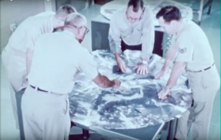
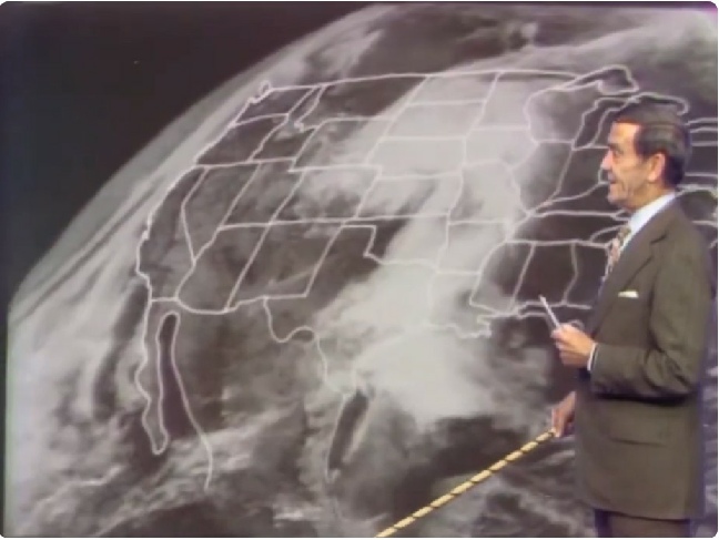
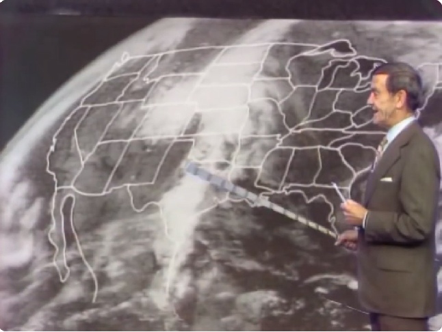
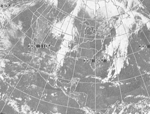
They were still unclear as to how clouds behaved and what the satellite images were actually showing, and much of the early research publications are based around ‘ground truthing’ satellite data. How, for example, could they have taken the satellite image of Hurricane Bernice from the day before launch and converted that into what was visible the day of the broadcast, as shown in figure 5.9.10.
That’s right, no computer terminals, no banks of whirring tapes, just a bunch of guys gathered round some print-
Jarrah also needs to consider that the TV broadcasts were made before the satellite images were available, so in order for his scenario to be true it’s actually the weather forecasters who are having to fake the data to match Apollo images. Which is it Jarrah? Were all the world’s meteorologists in on it, given that anyone could get these satellite images? Is everyone wrong except you?
In a nutshell Jarrah, and everyone else who tries to dismiss the weather satellite data, is just desperately clutching at straws to try and handwave away the proof of what they are: ignorant bullshit artists.
Speaking of bullshit artists, this site came to my attention thanks to a moon hoax social media group. It was posted as a way of saying that the Russians never said “but it was faked”. They seem to have mistaken “some Russians are saying it was faked” for “actual Russians who know what they’re talking about said was faked at the time”, but whatever.
One article on there, namely this one, makes some claims that are relevant to this discussion, so let’s have a look.
We have to make allowances for Google translate, but in a nutshell their argument is that NASA used the ATS satellites in geostationary orbit to fake the Apollo images, and that they were able to do this by not releasing many images of Earth.
Let’s examine their nonsense.
One of their first objections to the available satellite image record is that ATS-
“Experiments successfully conducted with the ATS-
They conclude from this that there should be images of Earth in colour. The problem is that the colour television images are just that: colour television. ATS-
The authors then turn their attention to ATS-
This is, of course, utter nonsense. The colour images (and there were far more than the three claimed in the article, and not all of them were fully illuminated disks) were published because they existed. They existed because they could be taken. The Soviets had no influence on them whatsoever -
Obviously “Scott” needs to research how many satellites were working simultaneously, but “Xiaoyaozi”, the facebook name for the fake “Dr. Rasaviharii” (whatever he says, he’s not a doctor, he doesn’t work for the Chinese Space Programme) is desperately flailing to cover up the holes in his theories. I assume by “NASA website” he means the ALSJ (who do reference this site), which may be hosted by NASA but isn’t run by it. You may not like the source, but that doesn’t mean it’s wrong. It’s also telling that he can’t be bothered to verify the data. He’s either lazy or scared that it might shake his foundations too much.
Granted it is difficult to deny the interlinked nature of the various organisations involved. ESSA, NOAA, JPL, NASA are all involved in building and launching satellites and operating them afterwards, but while many hoax believers will raise a big “A-
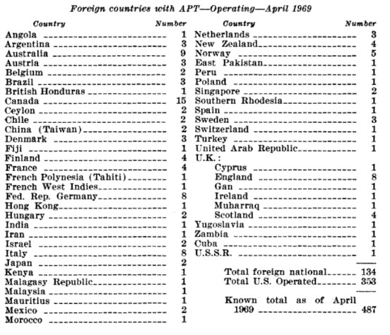
The other factor to bear in mind here is that the satellite images were 'free to air' broadcasts. Anyone could download them providing they had the equipment. As this 1968 first day cover in figure 5.9.2 shows, 45 countries used the data that these satellites collected.
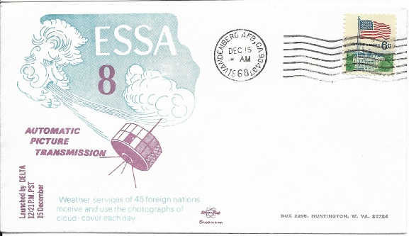
Figure 5.9.2: First day cover from my collection celebrating the launch of ESSA-
An advert in a well known journal in 1969 has adverts for ‘inexpensive’ satellite receiver systems (see figure 5.9.4)
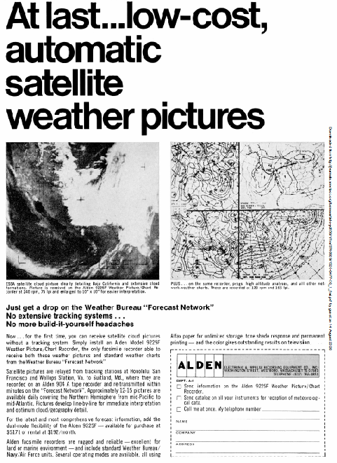
Figure 5.9.4: 1969 Advert for satellite receiver system.
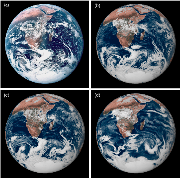
There is an interesting corollary to this argument. While the photographs are not exact replicas of Apollo images, the powerful modern computing techniques applied to the available data at the time were able to produce good facsimiles of them. Despite not having the computing power to predict what the visual appearance of Earth’s weather system would look like, Apollo photographs are a very good match with those created by 21st century computer models. In other words the modern techniques verify the accuracy of Apollo’s imagery. This can only be because it’s genuine.
By way of comparison with modern technology, figure 5.9.12, taken from a video promoting the DoD’s DMSP programme, shows just how advanced the interpretation of weather images from space in the early days of the science.
Not to mention this film, again freely available, that showed the passage of night and day across the Earth’s disk.
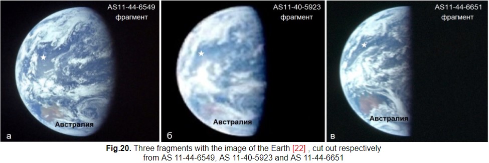
The authors then move on to construct ever more elaborate strawmen. They have managed to find two special publications (Life Magazine and Look magazine) both of which contain one image of Earth, namely AS11-
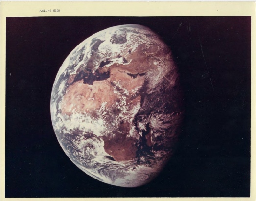
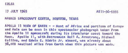
Figure 5.9.14: Original print of AS11-
Likewise they need to contact the owners of other publications and websites to ask them why they produce different distance and date figures from NASA’s, and edit the image differently. The actual facts have been freely available for over 50 years, you just need to be prepared to look for them. They are not different images taken on different days, they are the same image that people have given the wrong information for. Do your research!
There’s a lot more strawmen production and “this is what they must have done” involving nothing more than fabrication and ignorance.
Different images of Earth are claimed to be reproductions using satellite images with no proof. They claim that because geostationary satellites can be placed in transfer orbits that allow them to change position, then they must have moved them around. They would have been very busy, because at the same time as Apollo 11 was photographing Africa ATS-
It’s worth bearing in mind here that an image was taken every 20 minutes by ATS-
Likewise their accusation that ATS-
Like many hoax idiots, they assume that NASA is behind this flickr account and claim all other images of Earth have magically appeared in 2004 when in reality they were publicly available at the time -
They ignore all the 16mm and TV images of Earth and seem to think that the only images that exist are ones in popular magazines, not realising that documents like this published all of them. They don’t seem to know that there are images taken at regular intervals that can’t possibly have been taken by a satellite because it couldn’t have moved that far or that fast.
They don’t trust the electronic versions of the photographs but don’t seem willing or able to find the many original copies that exist out there.
They base a hefty chunk of their hoax claims on the editorial decisions of magazine editors rather than the facts that are available to anyone who cares to look: Apollo happened, weather satellites are the nail in the coffin of the hoax, not some magic wand they can wave at their illusions.
Doesn’t matter whether the cow that laid the turd is Australian or Russian -
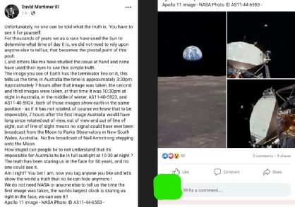
We get a recent and particularly aromatic addition to this particular section in the form of a facebook post on a moon landing hoax group, a group that helpfully collects all the world’s stupid in one place where we can keep an eye on them.
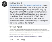
The poster first became noteworthy by declaring that images from the surface were fake because they didn’t show the Americas, which was mainly because he couldn’t tell the difference between am and pm when setting the time in his astronomy software. That post disappeared, to be replaced by one that didn’t understand time zones, didn’t understand that the landing and the photography happened at different times, got the date of his chosen photos wrong and didn’t seem to realise that there was a camera in orbit at the same time as on the ground. A collection of screenshots are shown in figure 5.9.21 for your amusement, and to record for posterity that he offered £10k (twice) to prove him wrong.
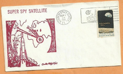
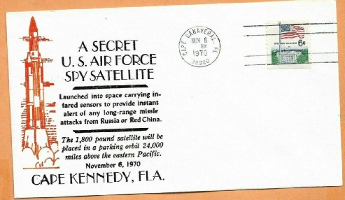
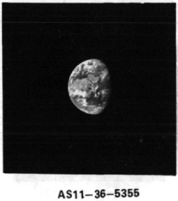
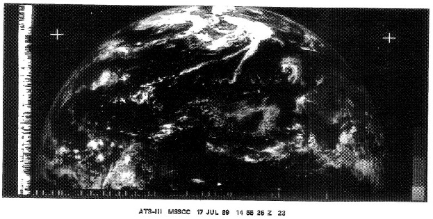
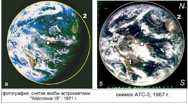
Figure 5.9.15: Images of Earth taken from the original 70mm catalog compared an the ATS-
There is no way ATS-
They make the same kind of claims for Apollo 15 and AS15-
Unfortunately for them there is an ATS-
Figure 5.9.17: ATS-
The authors handwave away any possible counter-
Well, for one thing the continents are not in an identical position, and for another this article, this article and this article all have ATS-
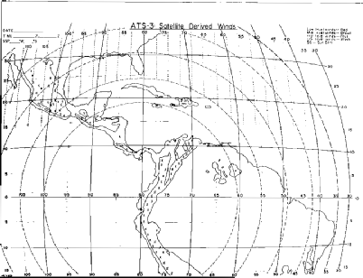

Figure 5.9.19: Position of Africa in Apollo 15 image compared with ATS-
Figure 5.9.18: Apollo 15 image compared with ATS-
When another user pointed out (for a different reason, see here) that a black and white photo existed he declared that it was a satellite photo, saying this (figure 5.9.22).
There’s a lot of word salad there, and as you might imagine very few of those words are actually his. It’s heavily lifted from this publication. In a nutshell, what he’s trying to intimate is that you can’t see city lights, therefore it’s a fake because satellites also don’t see them. The reality is that you can’t see city lights for pretty much the same reason you don’t see stars in Apollo photos: exposure time. It doesn’t help his case that the article in question discusses infra-
“In other words, urban lights emit, on average, significantly lower power than solar radiation reflected by soils. However, the difference between the two sources becomes small in the narrow spectral bands in which city light emission is concentrated.”
In other words, if we look at (for example) orange sodium lights and compare it with the same light frequencies in solar radiation reflected back, there isn’t much between them. However, reflected sunlight isn’t just orange -
On top of that, we also know that there are whole sequences of these black and white images that show the Earth rotating -
What he’s doing, as he has done all along, is demonstrate his lack of knowledge of the subject, his lack of awareness of just how many Earth images there are, and a willingness to cherry pick information that suits his narrative even when it doesn’t. Sadly, the thread got deleted. Why? Figure 5.9.23 has the explanation, given to someone wondering why entire threads were deleted.
,,

That’s right, you really don’t need any help to look really dumb, you manage it all by yourself.
Speaking of dumb, it’s worth checking a new claim about satellites, discussed in the Apollo 11 section here.
It was originally claimed by Bart Sibrel that the views of Earth were done in LEO by superimposing a transparency of Earth on the window. For years hoax morons have swallowed that bullshit whole and made merry without, despite all the flaws, misrepresentations and outright lies in his arguments.
The new claim (and its later ‘refinement’ where one AI is asked about another AI’s opinion is shown below in figure 5.9.24.
Figure 5.9.21: Selected screenshots from a hoax group trying to claim the same image is faked differently for different reasons.
Figure 5.9.22: Selected screenshots from a hoax group claiming that an apollo image is a weather satellite view. Also included is a cropped version of the image.
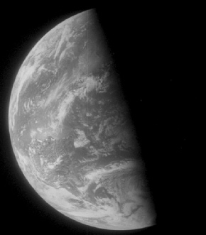
Figure 5.9.23: facebook group admin explanation for disappearing threads
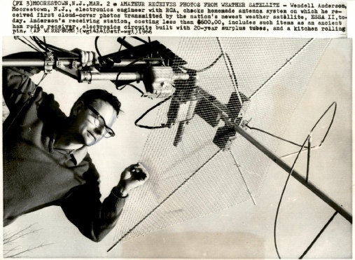
Figure 5.9.5: Amateur enthusiast builds his own satellite receiving kit (1966) (Sourced from ebay)
5.9: NASA owns the satellites, they have all the opportunity to fake satellite images
It is another feature of those who believe that the moon landings were faked that NASA is some omnipotent organisation that both controls and dictates all of the scientific information worldwide on any facet of the space programme by anyone, ever. This is despite the fact that they hold them to be incapable of the most basic science in the alleged fakery.
They are unable to grasp the idea that once the satellites were launched, they were no longer the responsibility of NASA but of the organisation that paid for them. It’s like assuming Ford are still entirely responsible for everything that I do in my car.
Figure 5.9.1: Social media arguments against the use of satellites
Figure 5.9.3: Right -
‘Inexpensive’ is debatable, $5171 was a lot of money back then, but you could always just make your own (see figure 5.9.5 above).
Readers who looked over Apollo 16’s pages here will recall how The Guardian were publishing satellite images supplied not by ESSA, or NASA, but by a British university that had its own receiving equipment (figure 5.9.6)
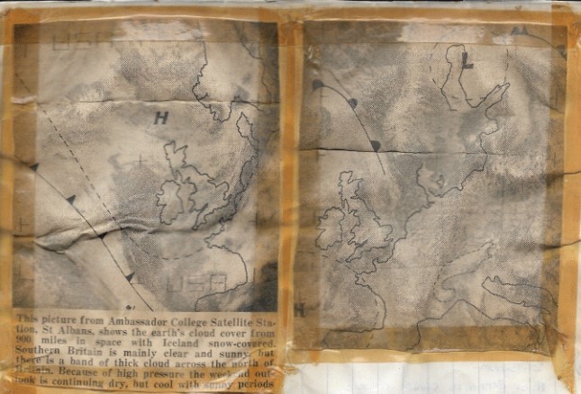
Figure 5.9.6: ESSA satellite images printed in The Guardian. Source.
Figure 5.9.11: Computer modelling of Apollo era data in comparison with actual photos (sources given in text).
Figure 5.9.13: Partially illuminated ATS-
Figure 5.9.16: Three images of Australia used in the Russian article. They were taken (left to right) at 01:00 20/07/69, 04:15 21/07/69 and 05:07 22/07/69
Figure 5.9.20: First day covers commemorating ‘secret’ satellite launches available on eBay

Figure 5.9.24: hoax claims. The lower comment is claimed to be an AI response to straydog02’s question.
So, we’ve now gone from a transparency of a bit of Earth to a satellite image.
It’s pretty clear that our barking mad friend is just parroting the Russian article -
Figure 5.9.29: Facebook claims about weather satellites.
We’ll deal with Crouching Dimwit, Hidden Brain cell’s comments first.
Firstly, no-
Secondly, again, NASA doesn’t control the USA’s weather satellites. That’s a different set of organisations. They also don’t control access to those images, nor do they control the Soviet weather satellites . Not one person, or organisation, has ever come out and said “These are wrong”. Ever. Because they aren’t.
Thirdly, if there’s no evidence to prove them, you have no evidence to disprove them. Not one single piece other than your “nuh-
Finally, anyone could verify the data. Anyone could intercept the satellite images. Anyone could get hold of them in the journals, regular compilations and daily newspapers -
The ‘free to air’ aspect extended to official co-
"At the end of the 1960s, China developed its first meteorological satellite cloud image receiver and began to obtain meteorological satellite images from ESSA satellite."
This article by Hank Brandli (the man who ‘saved Apollo 11’) describes how it was believed China were intercepting the freely available American images and supplying misinformation to counter their results.
“Evidence indicated that the Chinese and possibly the North Vietnamese also were processing daytime satellite photos, sometimes, intercepted surface observations reported bad weather when the satellite photos indicated just the opposite”
He also confirms that
“Anyone who had VHF receiving equipment could use the U.S. Weather Bureau and NASA satellites”
So the Chinese were more than happy with the veracity of US images to use in their own forecasting.
This exchange in a US Congress Senate Committee in May 1969 also confirms that their weather satellite image were freely availably, including to communist countries, and that “anyone who wanted to” could build a receiver (figure 5.9.7), while another document lists countries with receivers.
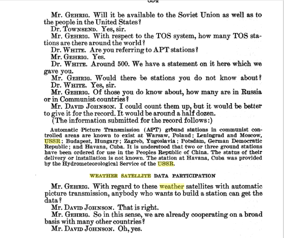
Figure 5.9.7: House of Congress discussion of ESSA activities.
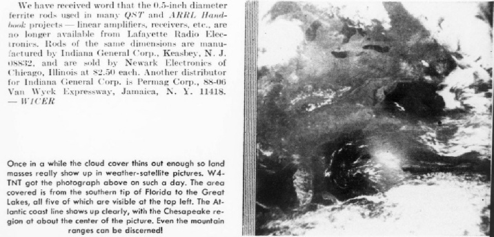
This video from Pathe News describes how the UK, which doesn’t yet have its own weather satellites, is building receiver stations for American ones. This document describes Canada’s use of the images,supplies examples of ones downloaded by its Toronto receiving station (figure 5.9.8), and mentions that 90 other countries have the same capability.
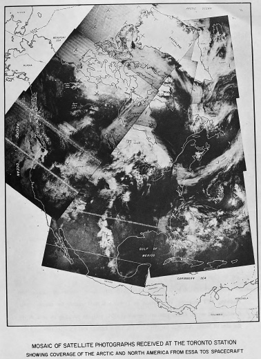
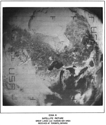
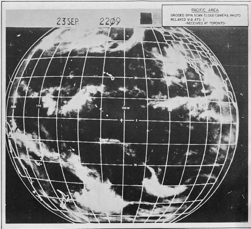
Figure 5.9.8: examples of Canada’s satellite image downloads.
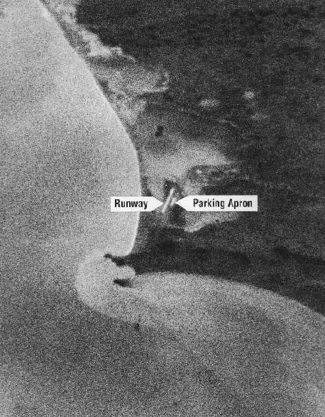
Figure 5.9.35: Discoverer XIV image of Mys Shmidta airfield
They argue that it is of poor quality, and little detail can be resolved. As the camera system for this early Corona satellite was unpressurised, that must be what’s causing it.
What they haven’t bothered to do is establish any further information about the image. It was actually taken on the second orbit of the probe, and the available documentation indicates that it suffered a brief hiccup in its orbital stability. Ironically, that orbital hiccup is what arguably led to the discovery of this previously unknown airfield just a stone’s throw from Alaska. Figure 5.9.36 shows the area covered during this orbital pass, obtained from the Earth Explorer website.
Figure 5.9.36: coverage of Eastern Russia on Discoverer XIV’s second orbit. Mys Shmidta airfield is roughly at the location of the blue dot.
The airfield falls within the much larger covered by one photo, which was taken towards the end of the photographic sequence. The airfeld photo is an oblique one, which shows that it was taken at an angle, rather then vertically down like others in the sequence. That oblique angle means the entire image covers a much larger area than would normally be the case, which dramatically reduces the amount of detail that could be expected from an already unambitious resolving power of around 10 feet. Figure 5.9.37 shows the actual image.
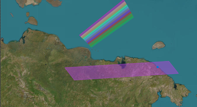

Figure 5.9.37: Image DS009009002DV058 from orbit 2.
The red square outlines the area in the photograph given in figure 5.9.35. As you can see, the area covered by the image is a very small area of the photograph, and it’s around 400 miles from the camera, rather than the usual 100 miles straight down. Similarly, rather than being a photograph roughly 325 miles long by 25 miles wide it’s an area around 750 miles long by 75 miles wide.
Despite that, however, the images available at Earth Explorer show that the actual quality is much better than the example shown by the ‘detectives’ (see figure 5.9.38).
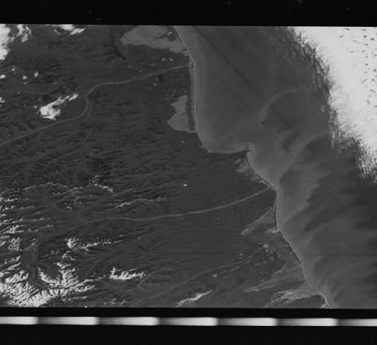
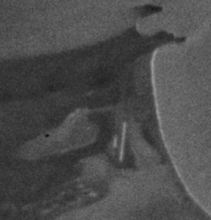
Figure 5.9.38: Above -
It’s certainly of better quality than the one commonly seen on line, and good enough to reveal an airstrip! The detectives complain that you can’t make out much, and even suggest that there should be lots of snow there, and that this is because the film is damaged by the radioactive vacuum in which it’s operating. Well, there aren’t actually many roads to see, because it’s the arse end of nowhere -
It’s also worth pointing out that this was on only the 2nd orbit. It did 17 in total before the film was ejected and caught in the Pacific. If the damage was done so quickly, then by golly the stuff at the end of this short mission (only around 30 hours) would be ruined. Let’s see (figure 5.9.39).

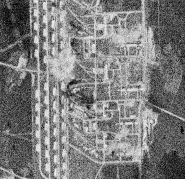
Figure 5.9.39: Above left -
Looks pretty detailed to me, and seemingly no deterioration in quality compared with the earlier part of the mission.
To cut a long story short, the various satellites used in early military reconnaissance either used no pressurisation at all, because it added mass and complexity to the system, or if they did it was (as with the lunar orbiter system discussed here) to protect the photographic process, not the film. Small amounts of pressure helps keep film clamped to its photographic surface, helped stop the very wide negatives from curling, and prevented build up of water vapour from outgassing film causing it to hover above the platens. The relatively poor quality of the photograph on which the detectives have focused their myopic and watery gaze is nothing more than film grain seen on a very small section of a photograph covering a very large area. Later missions used better film and were capable of recording far more detail.
Even for the much longer mission and ridiculously complex film path of the Hexagon satellite, where the system was pressurised, documents like this report that the
"photographic properties of the film were negligibly affected by moisture content"
Yes, film outgasses, but not to the extent that it will ruin the image, and even less so when you develop a film that minimises that issue.
This document shows that this kind of problem was already considered for Apollo:
"When cameras and films must operate in high vacuum, camera lubricants are required which will not poison the vacuum environment if the camera is exposed to the full vacuum. Cameras have been used directly in vacuum, and in certain applications they have been enclosed in housings in which a partial pressure of air or nitrogen has been maintained. Few problems occur with respect to film exposure or its sensitivity in a vacuum. The major problems have been the generation of static, particularly with the high-
and
"In planning the Apollo missions, a hermetically sealed magazine was considered to maintain a suitable environment for the film. Many years of experience had included the use of photographic film in vacuum systems such as electron microscopy and electron beam recording, and this experience indicated that the disturbance caused by the vacuum environment should not prove too serious. This was confirmed by tests of extended exposure to vacuum conditions, and the Apollo 11 and Apollo 12 missions were carried out with a conventional unsealed magazine. Thus the film was exposed to the high-
In several experiments on film in a vacuum chamber reported here no significant impacts on the films were found.
In short, by comparing these missions with the cameras and film used for Apollo, you’re not just comparing apples with oranges, you’re comparing apples with elephants. They’re completely different systems, with different mission profiles and processes. Even when you do attempt to crowbar in a reference, it still doesn’t work, because the photographs they produce in an environment the detectives claim is universally hostile to film, the evidence shows otherwise, no matter how much you try and rig your results.
He also claims that;
“Projection onto ribbed surfaces was common in analog simulation.. It helped reduce glare and scatter light more evenly”
And that
“Langley used multiple projection techniques, one for star fields, another for Earth visuals”
And that he’d just “mixed up” the use of the star field projector. He also claims that the shots of Earth were achieved by “changing slides”, somehow ignoring the long unbroken sequences of Earth views showing rotation of the planet.
No. Just no.
Firstly, as already discussed, there was no colour satellite covering the views shown.
Secondly, despite his claims of “static Earth rotation”, the views rotated over time, including during the live broadcast showing Hurricane Bernice. See my video here for more on that. As for “dynamic parallax”, that is evident when comparing views of Earth shortly after TLI as they move out of orbit with photographs or live TV taken just a short time later.
Thirdly, the only satellite that could have produced the images took 24 hours to produce a whole day’s footage of Earth. Those images then needed compiling into a realistic sphere, colourised, then converted to a transparency. They simply weren’t available during the timeframe required.
Fourthly, that banding looks nothing like the pattern seen on the wall in the photograph, and the pattern stays the same no matter how the camera moves. His claim that they are an exact match in terms of configuration and dimensions are just, ahem, projection on his part. There’s another issue with his claim -
Finally, someone had to do all that. Someone had to do the projection, someone had to coordinate it all. Someone had to convince the team at Goldstone that they weren’t getting a signal broadcast from Langley. All on live TV. That’s right, live TV. The claims that the images and radio were not coordinated is garbage. It’s a combination of goalpost moving and clutching at straws producing an ever more complex hoax scenario involving even more people. It doesn’t stand up to even the slightest amount of scrutiny. The claim that Langley’s “projection booth” was “known to use weather satellite images for training and simulation” and “Earth visuals” is flat out fabricated bullshit. The only reason AI “knows” it is because its interrogator told it that, not because it’s documented fact. Photorealistic projection was not possible, certainly not live colour views of Earth.
The actual fact of the matter is that the banding is just a product of how analog cathode ray tube screens worked at the time.
We have similar arguments employed in response to a comment regarding an Apollo 17 TV transmission specifically, and (some time later using someone else’s Facebook account) weather satellites in general (figure 5.9.29)
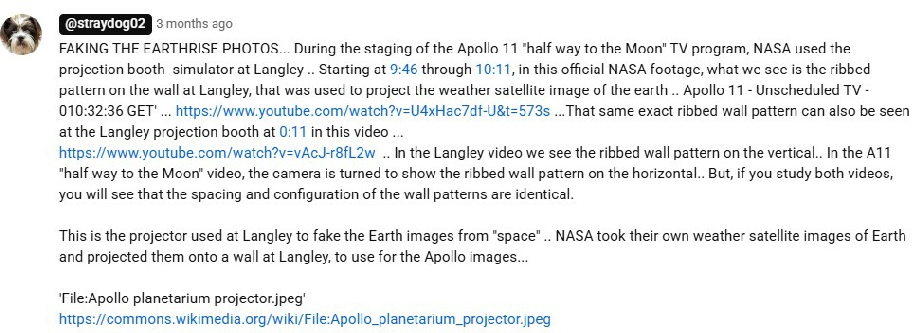
Figure 5.9.25: Allegations made about how Earth images were created.
I use screenshots so that no-
Figure 5.9.26: Apollo planetarium projector (source in text).
The image appeared in this report, which describes Langley’s efforts to produce useful simulations as preparations for the landings. If the dog had read up on the subject instead of just parroting claims by others, he’d have found out that the projector was used to project points of light to simulate known stars:
“centrally located highly reflective sphere which directs the light outward It consists of a point-
The ribbed pattern he sees are actually seams in the fabric sphere housing the projector. Here’s an image of that fabric sphere from this report, described as being 53 feet wide, meaning that the projections were 25 feet away from a pilot in the centre. Also shown is a much larger simulator from this report used for docking training, and images form other sources. See also this document, and this video has interesting footage of the docking simulator in action.
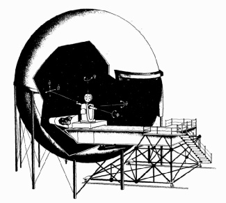
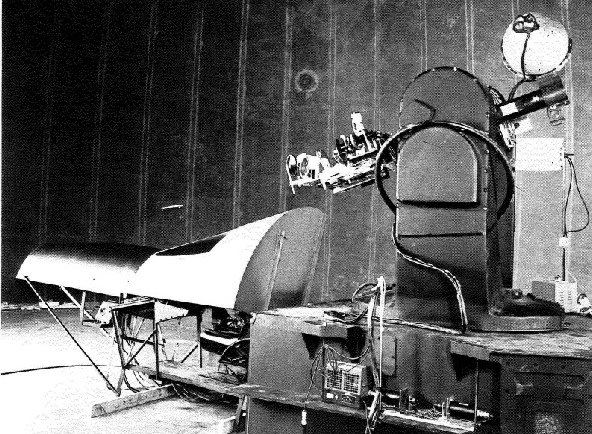
Figure 5.9.28: “Banding” in Apollo 11 live TV. The most obvious example has been used from the video linked to by straydog02
Figure 5.9.33: Comparisons of TV broadcast satellite views with ESSA data from the same dates.
The images used are from ATS-
Here’s another example of how you can verify it’s correct. Figure 5.9.34 shows a postcard of a NIMBUS-
There’s no date given in the Salzman broadcast, but he does use the word ‘moonshot’, which suggests that the the Apollo missions are in the news at the time.
A bit of data trawling gives the images from ESSA and Nimbus 3 for June 19th 1969 (figure 5.9.31).
Figure 5.9.31: ESSA (above top), scanned NIMBUS 3 document (above) and restored NIMBUS 3 geotiff (above right) and individual tile (right) views of North America on 19/06/69 (sources).
Well what do you know, weather forecasts using satellite images from space that can be identified as genuine.
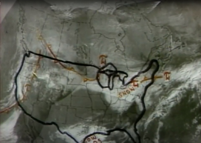
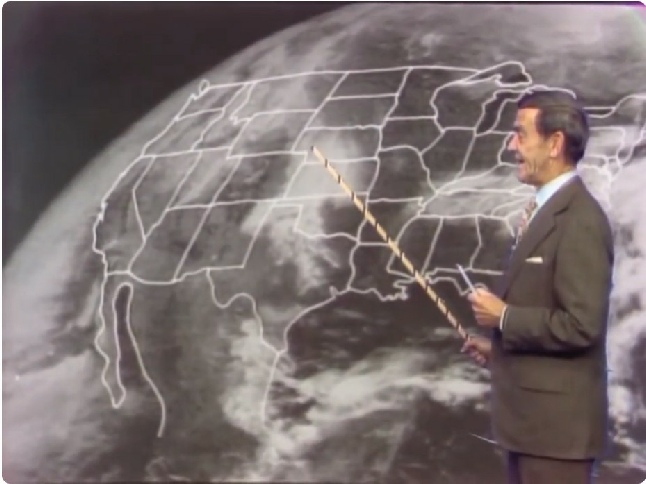
The forecast from 1972 is from a Wisconsin based TV station, and the reference to the earliest sunset gives us a clue as to the date -

Figure 5.9.32: 1972 weather forecast compared with NOAA-
At first glance it’s difficult to reconcile the two images as being from the same date, for a number of reasons. We can’t be entirely certain they are from the same satellite, and the modern scans of the images combined with the low quality of the broadcast image don’t help. That said there is the very clear mass of cloud over the southern Texas that connects across the southern states towards the north east. There’s a band of cloud off the east coast, and a separate thing band off Florida. Apollo 17 images from this date clearly show the long strip of cloud (see here), so we have a satellite image broadcast on the evening news that can be tied in with Apollo photographs.
But wait, there’s more. This weather forecast from 28/04/72 shows several satellite images that are relevant to Apollo 16 (figure 5.9.33).

Stray specifically claims that those vertical lines seen in the background are an exact match for banding seen in the live TV broadcasts from Apollo 11 (figure 5.9.28).
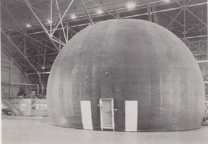
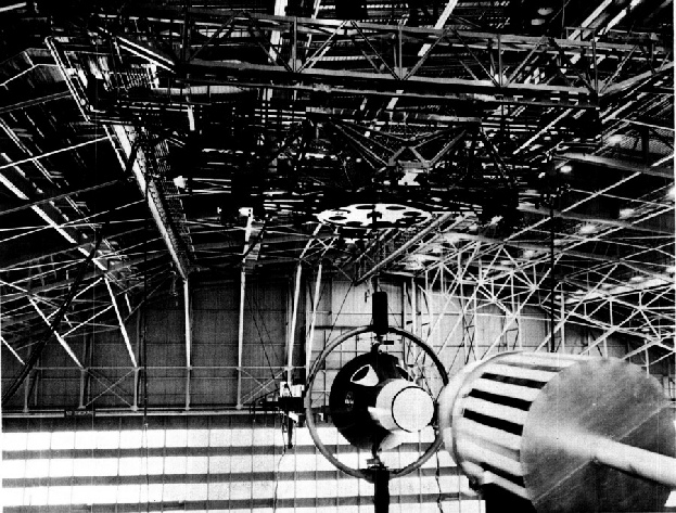
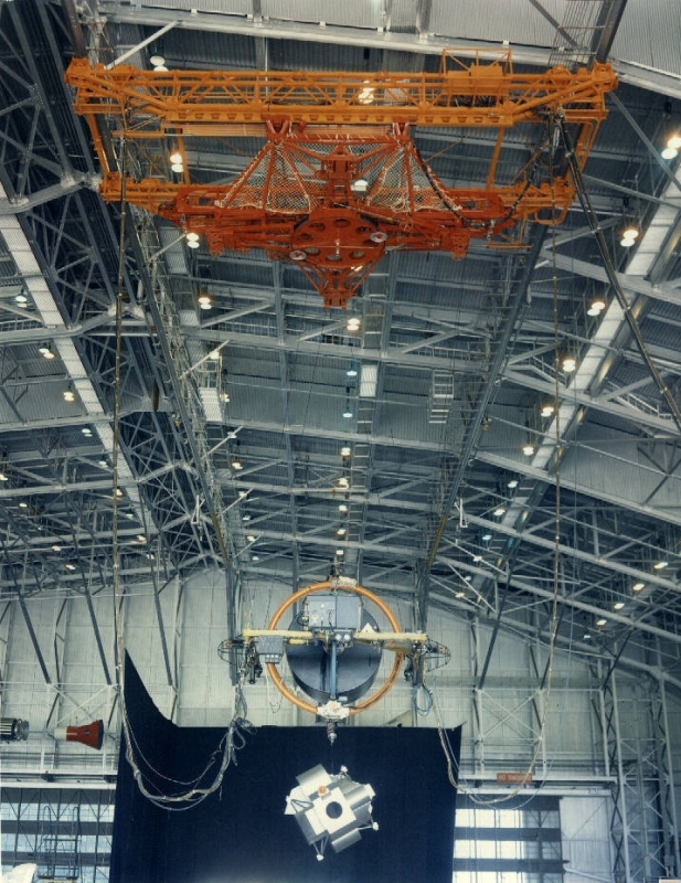
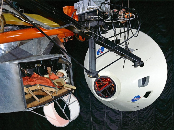
Figure 5.9.27: Inflatable projection dome and docking simulator
The date of [publication of the postcard isn’t known, probably the early 1990s when the printing company was around, but the fact remains: it’s in the public domain, as are all the other versions, and there is no difference in any of them. They are verifiable. So no, Rasa’s claims hold no water, satellite images were in public use, and all he has is pretty much “trust me bro” without any evidence.
Jarrah’s response needs more thought. His use of the word ‘propagandist’ is a typical piece of poisoning the well from him. This website isn’t propaganda, it’s an honest attempt to refute idiocy and ignorance. It makes him out to be some sort of victim fighting against the bad guys. He isn’t.
We have all seen weather forecasters predict the directions of clouds -
I’ve watched his video and he spends a lot of time getting hung up on semantics. He also claims to have found reports from NASA proving you can predict cloud movement using satellites.
This is the first one. The first point to make is that it is from 2005, using much more advanced satellites than were available to Apollo. The second point to make is that the study is not about predicting cloud movements, it is about comparing a model what happens during cloud seeding with actual imagery. It’s is confirming the accuracy of a model, not predicting how clouds move.
The second one he cites is from 2008, 40 years after Apollo 8! It is also, again, using data to confirm the accuracy of a model, and the report concludes that the predictions are ‘reasonable’ for the short term, less so for the longer term. 40 years after humans first photographed Earth from lunar orbit, meteorological models are still not good at predicting the future.
This is the final one he uses, and this one is at least from the Apollo era. Again, it’s using actual imagery to confirm how well a model does, but in no way can it be said that this model is accurate enough to show a precise and exact model of Earth’s cloud distribution with the accuracy shown by Apollo imagery.
Jarrah does point out that there are well know global patterns that recur regularly, and infers from this that the images are just using what we now know to fake the imagery. However, we only know that these patterns occur regularly because of satellite meteorology. We didn’t have decades of observation to back up this idea 50+ years ago. Furthermore, while we can say that there will always be, for example, an ITCZ, or a south Pacific ‘V’ cloud distribution, we can’t make exact and precise predictions of exactly what those patterns will look like and when they will appear. The only way we can do that is with precise, 100% accurate computer modelling, and we’re only now acquiring the ability to do that.
To clarify the point, this article describes how the use of satellites to actually forecast weather only really became possible with the introduction of atmospheric sounding instruments (eg looking at temperature, moisture and water vapour) on Nimbus 3 in April 1969, describing how meteorologists stayed up “all night” to analyse data and show the position and movement of atmospheric currents not visible to normal cameras. Even these instruments were unable to penetrate cloud cover, and it wasn’t until the use microwave sounders from 1978 onwards that complete atmospheric profiles (the kind previously gathered by balloons) were available to forecasters.
This 1969 article discusses the potential uses of satellites, again describing the limitations mentioned above. The mathematical models of weather development using computers are promising, it says, however:
"Although the accuracy of current forecasts usually deteriorates rather rapidly beyond 48 [hours], integrations for up to 5 days, with even the present rather crude model, produce coherent atmospheric patterns that retain some reality in their broad features though they may be incorrect in detail. These and other investigations encourage us to believe that, given adequate observations and computing facilities, it should be possible within the next few years to produce reliable forecasts of the basic weather patterns for 5 to 7 days ahead, and a useful indication of general trends over periods of perhaps 2 to 3 weeks."
So short term forecasting is reasonable, but the kind of forecasting required in Jarrah’s view of the state of the art at the time just isn’t available. Furthermore, it says that:
"...it is one thing to measure the spectral distribution of radiation received by the satellite from the underlying atmosphere, and quite another to deduce from these measurements the vertical distribution of atmospheric temperature or humidity with the accuracy required for use in numerical forecasting."
It’s that vertical distribution that was only just beginning to be measured at the time of Apollo.It confirms my view stated earlier that:
"…the accuracy of the observations required by the sophisticated mathematical models of weather prediction...impose stringent requirements on the measuring techniques and a basic network of conventional surface and upper-
Similarly this article in the November 1970 edition of ‘Popular Science’, says
“Reliable long-
And that
“Today, while we know the general equations [of the Earth’s energy balance], we do not know many of the numerical figures we would have to feed into the computer.”
It concludes that a reliable five day forecast will be available “10 years from now”.
There’s even the evidence during Apollo 13 (see here), where the world’s first global forecasting model was attempted using inputs from both conventional and satellite records -
"The public benefit is tremendous but the system is still too new for its potential to be fully realized."
Then we have this quote from May 1969’s Spaceflight magazine discussing the next generation of NIMBUS satellites, which says that:
“At present the cloud pictures and radiation data from satellites currently provide a great deal of valuable information, but it is mainly qualitative in character and difficult to incorporate directly into numerical production [sic] models.”
In other words, when Apollo was taking photographs, 16mm film and live TV views of Earth, weather forecasters were only just acquiring the ability to take the measurements that would have been needed to predict with absolute certainty the weather patterns shown in them. That certainty would not come for decades, and is arguably still not totally there. Forecasters were certainly not getting it right from satellite images just before Apollo 11 -
He also gets hoist by his own petard by nitpicking over the difference between weather and cloud patters -
There’s also the small matter of Landsat’s exact replication of the Antarctic ice flows seen in the Apollo 17 imagery. Where are your computer models for that?
Again, Jarrah, you don’t “know” anything, you’re just retro-
And again, it is a moot point: it doesn’t matter whether or not something was possible (it wasn’t), the question is “was it done”. If you think someone managed to produce real time computer models showing how Earth could have looked days in advance and then made live TV, 16mm film and high resolution photographs on the back of that prediction, prove it. Find who did it, where and when. Show us the computer models and graphics processors. You can’t because it didn’t happen.
You’re also forgetting that these allegedly fake Earths are backed up by actual satellite images. In other words, ‘they’ somehow used satellite images to model Earth’s likely cloud distribution, and it just so happens that the satellite images taken later are an exact match. This isn’t possible now (just good estimates) and certainly wasn’t then. 100% accurate predictive satellite photography is just not a thing.
In reality, this is the same old hoax tactic: make a claim, find out it’s stupid, move the goalposts. Bad news: it’s still stupid.
One final point about satellites is a claim made by Marcus Allen in a youtube debate that satellites could have been used to somehow simulate the Apollo missions and fool the casual, or even expert, observer. That claim is repeated in a book Allen co-
"It was not only the astronauts that required extensive training but It was not only the astronauts that required extensive training but also the mission controllers. To do this NASA created many simulation exercises that covered the complete mission. on 13 December 1967 NASA launched the TETR-
The specific satellite he quotes are the TETR series. These were a series of satellites launched in 1967-
“TTS, TETR, TATS (Test And Training Satellite) were four very small magnetically stabilized satellite instrumented with a s-
Its external configuration was an octahedron, 28 cm on each side. It was powered by solar cells mounted on the octahedron surfaces and nickel cadmium batteries. The instrumentation included the 9.5 Watt s-
TRW were also responsible for building communications satellites, and also the descent module engine. They were launched on the same rockets that sent the Pioneer probes on their missions, but
This publication describes how they were used as tracking targets for the newly formed Manned Space Flight Network of tracking stations so that ground personnel could become experienced in tracking orbital targets, providing:
“targets for checkout and training of equipment and operations personnel"
TETR-
The most detailed source of information about TETR-
Launched on 06/11/68, it was to provide:
“an active, orbiting target for training MSFN Unified S-
Particularly acquiring and handing over a moving target at each of the fixed and mobile monitoring stations of the network. The intention was to provide a minimum of 3 hours acquisition and tracking experience at each stations, and a minimum of 10 handovers.
The key element here, however, is the remote “voice tests”, sent using SCAMA (Switching, Conferencing, and Monitoring Arrangement) to those stations capable of receiving them. What isn’t clear is what specifically those voice tests were, and how they were sent, but this document outlines that they tested how intelligible voice transmissions were, whether there were drop-
"The satellite will also enable the MSFN to exercise the voice communications system when the satellite is in view of two stations simultaneously by uplinking voice from one station and receiving it at the second station."
There’s also quite an assumption about what ‘voice’ means. The assumption by the Apollo hoaxers here is that it voice, when in reality it could just be a tone that could be evaluated for consistency. Honeysuckle Creek personnel do mention the use of scripts to ensure the use of correct terminology (and even trying to emulate American accents) in simulations, but it isn’t clear as to whether which sort of mission simulations they mean. This page has recordings made in the 1970s of both TETR-
So, despite the initial evidence suggesting that they were only capable of sending tracking telemetry (something I freely admit I believed for some time), the transmitters aboard the satellites were capable of relaying voice.
Does this mean that they could fake Apollo transmission?
Well, as they were LEO satellites they certainly wouldn’t have been able to do so for the hours at a time that the live TV broadcasts from Apollo, or the continuous voice transmissions. The stations relaying actual Apollo comms are clearly identified, as are the various handover and acquisition times, Those times are absolutely not consistent with the actual record. We also know that the Apollo transmissions contained ‘live’ data on, for example, news and current affairs, so they couldn’t have pre-
Interestingly, the document referenced above has this to say about them:
“Generally speaking, the first two TETRs were not as useful as had been hoped originally, for two reasons: first, they were not in operation long enough; and, second, the timing was off; for example, TETR-
And that:
“While the TETRs were useful in testing the network in the area of satellite acquisition and handover, they of course could not simulate the lunar phases of the Apollo mission”
concluding that the Lunar Orbiter probes proved more useful to the training of tracking staff. Honeysuckle Creek personnel also mention Ranger and Surveyor as invaluable learning tools. This press release for Lunar Orbiter V confirms that those were used for tracking training:
“All three operating Orbiters are used as tracking targets by the NASA Manned Space Flight Network stations, providing a valuable method of exercising and evaluating the tracking network and the Apollo Orbit Determination Program”
The reasons why TETR weren’t of any use for ‘faking’ the lunar aspects should be obvious. The elliptical orbit of TETR-
You‘d also have to wonder why, if the Apollo astronauts were in a CSM in LEO all the time, why would they need an orbiting satellite? Just use the CSM! The more complicated conspiracy theory that the voice transmissions apparently relayed to an S-
The TETR satellites were also still being used for training while Apollo missions were actually happening (see here) -
Hilariously, in order to cover up the huge gaping holes in their dumbass theory, some claimants argue that the TETRA satellite was setn from Earth orbit to the moon in order to transmit fake voice signals:
“They say it was deorbited 6 months later. But was it? Or was that Tetra A satellite still transmitting? That could have been put into orbit around the moon quite easily being an unmanned craft.”
Yes, that’s right, they launched a small satellite into Earth orbit for 6 months, then (without any of the fuel required) sent it to the moon somehow. It then orbited the moon without anyone noticing. Can we see the evidence for that? No, we can’t, it’s bullshit. It’s what educated and informed people call “pulling it out of your ass”.
And finally, again, even if they could have been used to transmit the mission audio and TV, it doesn’t mean they did.
There’s another element to the role of satellites that has reared its head of late, namely that the film and photography techniques used in cold war era spy satellites (like those already used in this study) proves that Apollo film cameras couldn’t have worked. It follows on from work by the so-
As usual, their version of events tells only half the story.
Their analysis starts with discussion of the image shown in figure 5.9.35. Taken on August 18th 1960 by Discoverer X14, the first successful use of the film recapture process (designed to prevent interception of TV transmissions of the type used in weather satellites.
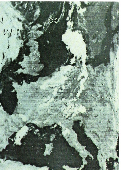
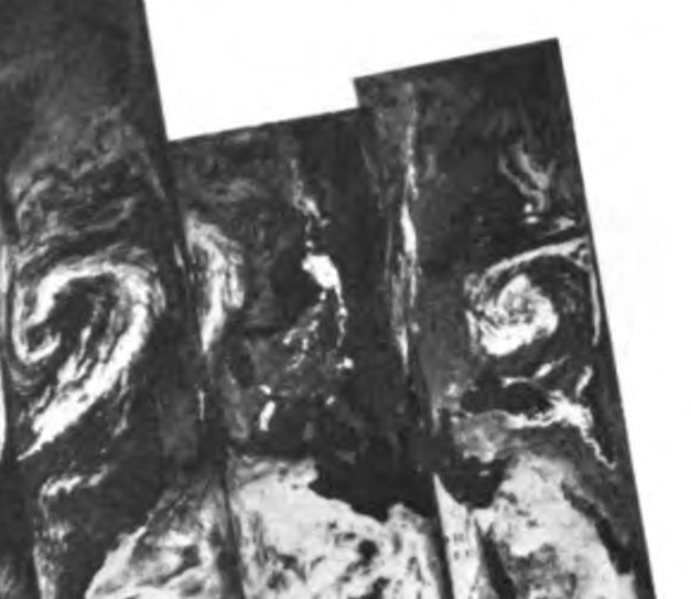
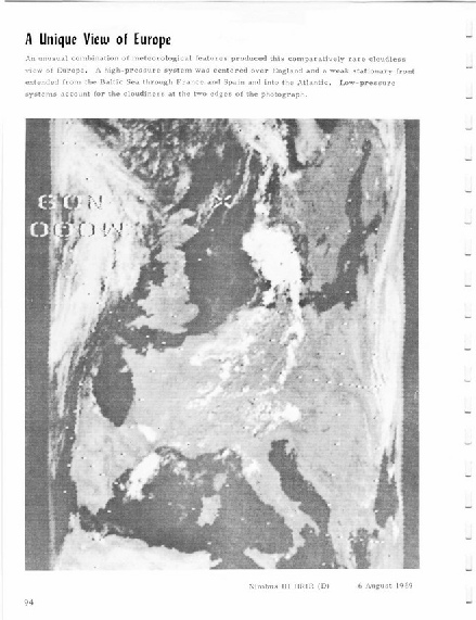
Figure 5.9.34: Infra-